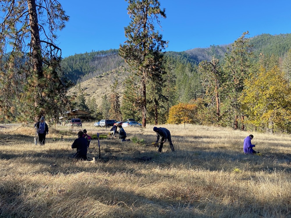
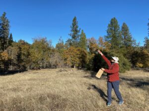
ASA volunteers planting native grasses and wildflowers at Nick Wright Flat along the Upper Applegate River.
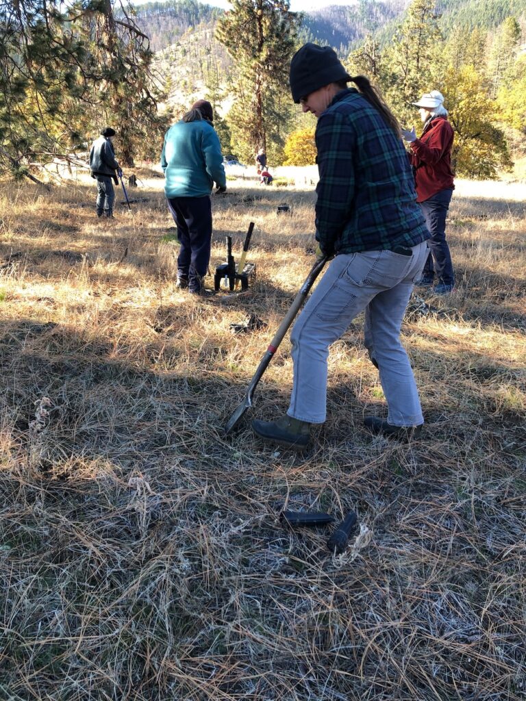
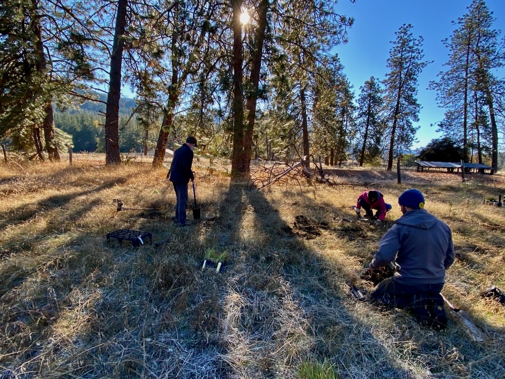
This weekend Applegate Siskiyou Alliance worked with a hardy group of 10 volunteers to plant over 1,800 native grass and wildflower plants at a habitat restoration site in the Upper Applegate Valley at Nick Wright Flat.
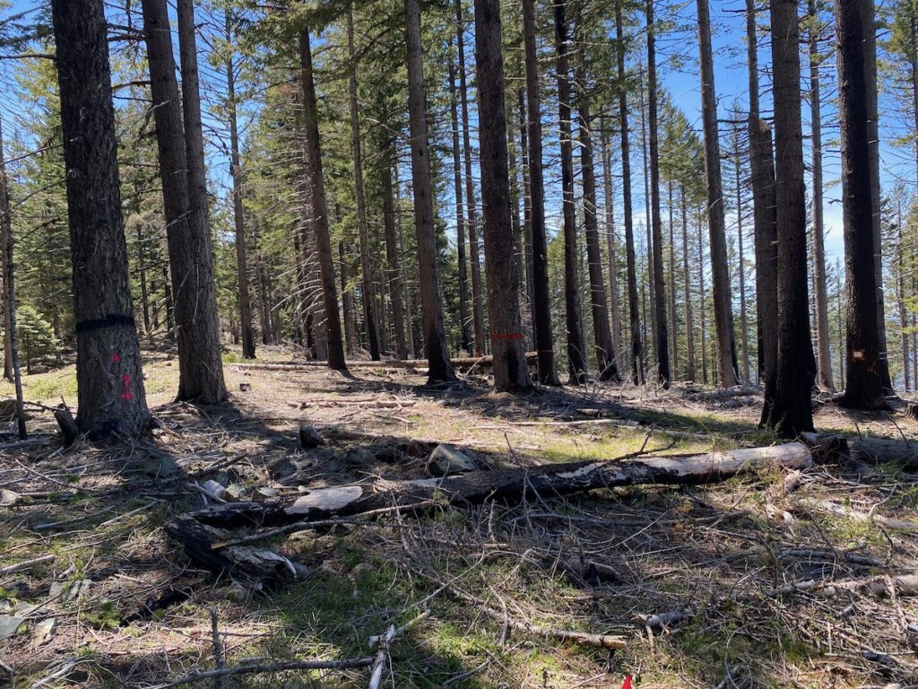
For six years Applegate Siskiyou Alliance has been stewarding this beautiful river terrace above the Applegate River. An unusual piece of publicly owned valley bottom land, nestled between homesteads and ranches, the site includes a large open meadow which has been largely converted to non-native grasses and weeds, along with some small remnants of native herbaceous vegetation. The site also includes open-grown ponderosa pine, Douglas fir, black oak, white oak, live oak and small tufts of bedrock protruding from the otherwise relatively level, meadowy river terrace.
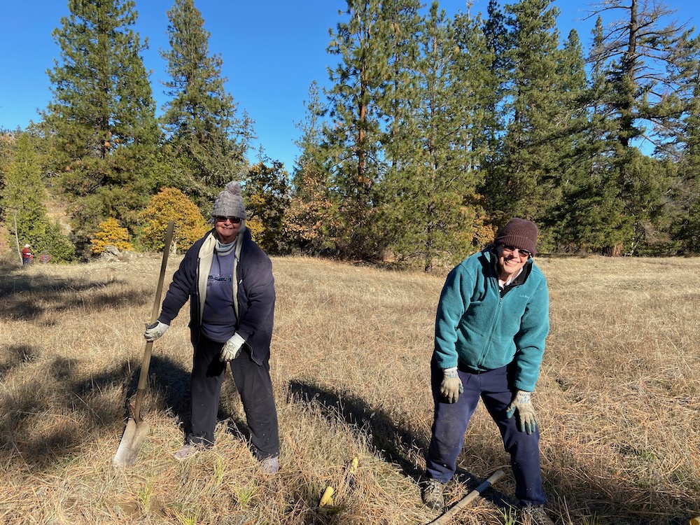
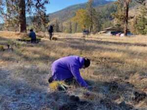
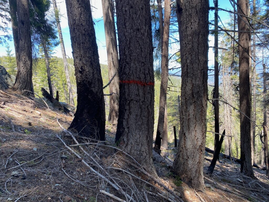
Barb Mumblo, retired Siskiyou Mountains Ranger District Botanist (right) and Joy Savoie (left) planting squirreltail grass.
Working in collaboration with the Rogue River-Siskiyou National Forest and Siskiyou Mountains Ranger District, who own the land, we have planted small areas within the grassy river terrace, year after year, in order to reintroduce native grasses and flowering species for the benefit of native butterflies, bees and other pollinating species. In some locations, older more established plantings are now providing both pollen and nectar for pollinators and beautiful floral displays that National Forest visitors can appreciate. In other locations plantings and seedlings are still getting established, and on our recent volunteer planting day new plugs, donated by the Rogue River-Siskiyou National Forest and Klamath-Siskiyou Native Seeds were planted in blocks throughout the site.
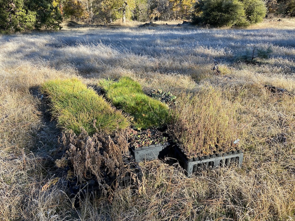
Our day’s work in the morning before we got started.
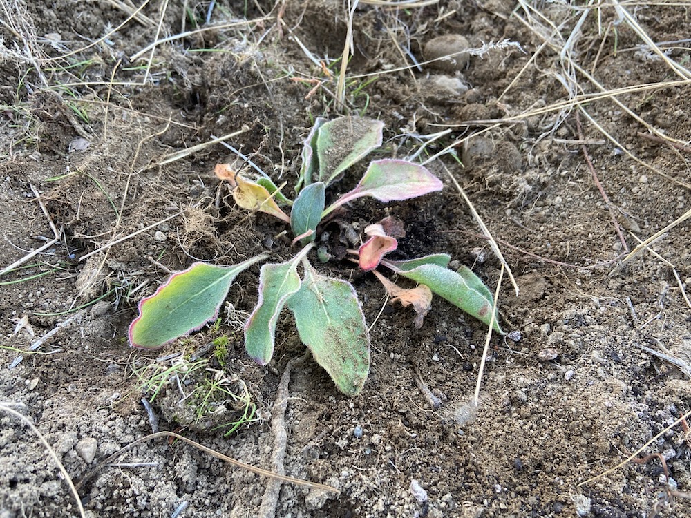
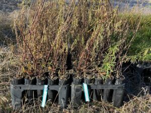
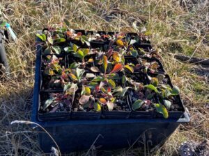
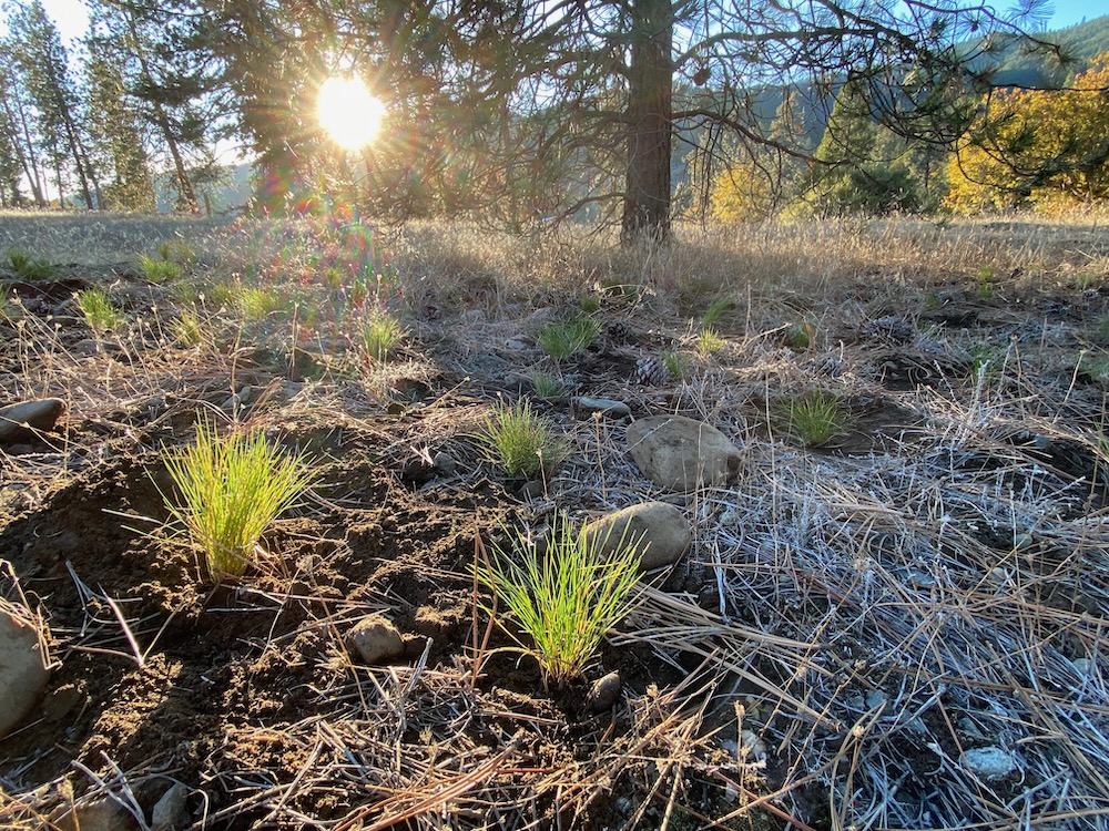
In this round of planting we planted six species and approximately 1,800 containerized plugs, including the following species: showy milkweed (Asclepias speciosa), narrowleaf milkweed (Asclepias fascicularis), cobwebby or western thistle (Cirsium occidentale), squirreltail grass (Elymus elymoides), and Roemer’s fescue (Festuca roemeri) donated by the Rogue River-Siskiyou National Forest.
tall woolly wild buckwheat
A tray of 25 tall woolly wild buckwheat (Eriogonum elatum var. villosum), an uncommon species in Oregon, were donated by Klamath-Siskiyou Native Seeds for planting at the site. These plants were grown from seeds from existing tall woolly wild buckwheat plants that grow near the restoration site naturally. Tall woolly wild buckwheat only grows in a handful of locations along the rocky banks of the Applegate River today, but was likely much more abundant before historic mining impacts altered the Applegate River’s native flora, so we are pleased to increase this beautiful and important species’ population in its historic range along the Applegate River corridor.
Suzie Savoie from Klamath Siskiyou-Native Seeds planting showy milkweed.
We are both excited and proud to steward this beautiful piece of the Applegate Valley, by reintroducing native species and removing non-native and invasive plants throughout the site. We also enjoyed a beautiful winter day, under blue skies and beautiful mountain ridges, working with our friends and neighbors in the Applegate.
Thanks to the Rogue River-Siskiyou National Forest and Klamath-Siskiyou Native Seeds for the donated plant material, and thanks to the volunteers that came out and helped! We couldn’t do this important work without awesome volunteers!
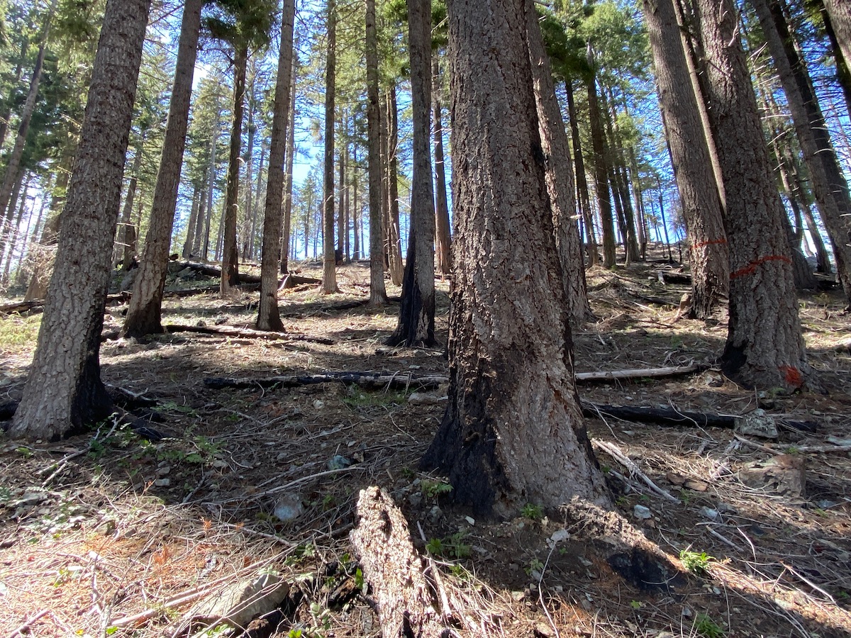
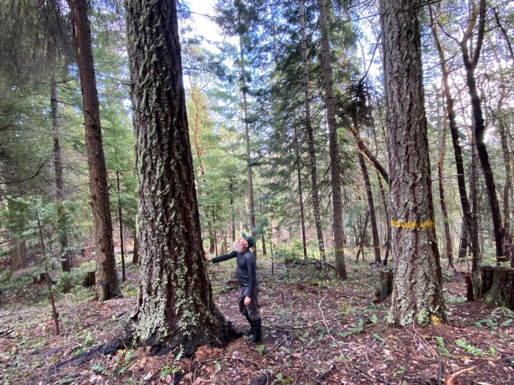
This large old cedar in unit 25-1A of the Penn Butte Timber Sale is proposed for logging under the provisions of the IVM Project, which promotes heavy industrial logging without scientific analysis, environmental review or adequate public involvement processes.
In recent years, the Medford District BLM has become increasingly secretive, non-transparent and hostile to both the environment and to the communities of southwestern Oregon. In areas like the Applegate Valley where opposition to old forest logging has been consistent and overwhelming, the BLM has changed the rules of engagement and has begun cutting the public out of the public land management planning process.
Rather than address public concerns or opposition to old forest logging proposals, the agency has instead insulated itself from critique by expediting the planning process, eliminating all avenues for meaningful public input and by refusing to implement site-specific scientific analysis and/or a credible environmental review process. This means that the BLM no longer notifies the public of its logging plans until the are “finalized” and no longer discloses, quantifies or analyzes a proposed project for cumulative and direct environmental impacts.
Public collaboration will be severely limited under the IVM Project and will only occur after the BLM has “finalized” a timber sale design and tree removal mark, leaving little opportunity for meaningful public involvement.
For many, many years the BLM has worked to circumvent its obligation to the public and the NEPA process, while pushing for increased timber production throughout western Oregon. In our region, this began to intensify in 2016 when the agency eliminated the Applegate Adaptive Management Area, a designation specifically meant to encourage open, transparent planning processes and public collaboration. Unfortunately, this trend has now culminated with the IVM Project where the public is being largely shut out of the process and timber sales are designed in the dark, without public oversight or engagement.
According to the IVM approval documents, public involvement is now fully discretionary on over 630,000 acres of BLM land in Southwestern Oregon, and the agency can log these landscapes with little to no public accountability. Although the BLM claims the IVM Project is based on the concepts of forest restoration, to many it is clear that the real goal is not just to get the cut out on BLM lands, but to also cut the public out of the process.
The Medford District BLM recently published its 2023 Timber Sale Plan identifying the commercial logging projects the agency intends to implement during the next year. On this list are four major timber sales in the Applegate River watershed, totaling 1,674 acres and an estimated 13.7 million board feet of public timber.
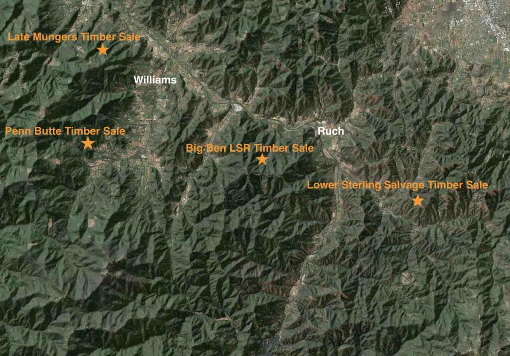
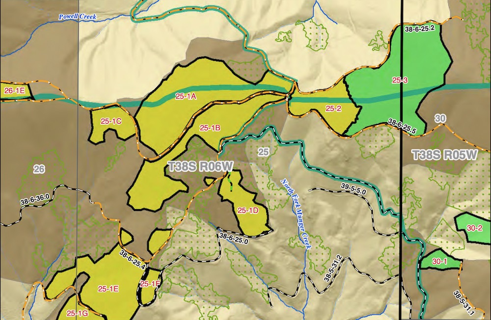
BLM timber sales are currently proposed all across the Applegate Valley as depicted on this map. The orange stars show the general vicinity of the timber sales proposed. The Penn Butte, Late Mungers and the Big Ben LSR Timber Sales are proposed under the IVM Project and the Lower Sterling Salvage Timber Sale under a Categorical Exclusion. None will include full or adequate NEPA process.
These four timber sales are proposed throughout the watershed on Sterling Creek, in the Middle Applegate, and on Williams Creek, where two large timber sales are currently proposed. Although these timber sales contain a wide variety of habitat types and forest conditions, they share one thing in common: a distinct lack of meaningful public involvement and a total lack of credible scientific analysis or environmental review.
The Late Mungers, Penn Butte, and Big Ben LSR timber sales are proposed for implementation under the provisions of the IVM Project. In these areas, the BLM has authorized a “program of work” which would log up to 20,000 acres and build up to 90 miles of new road in the next ten years, and the agency has begun implementing the IVM Project exclusively in the Applegate River watershed.
The Late Mungers Timber Sale is “leave” or retention tree marked, meaning only trees marked with yellow paint would be retained. The old “unmarked” fir trees in unit 7-1 would be logged if the Late Mungers Project is approved and sold to the timber industry for commercial logging.
Each individual project or timber sale implemented under the IVM Project is now being fully designed, marked for timber sale removal and tentatively approved with a Draft Determination of NEPA Adequacy before the BLM notifies the public of their plans or incorporates a single shred of public input. Only after “finalizing” their timber sale proposal will the BLM release any information or accept public comment on the proposed projects.
No longer serving the public interest or working on our behalf, the Medford District BLM has fully committed to serving the interests of the private timber industry — the secrecy surrounding these four timber sales drives that point home.
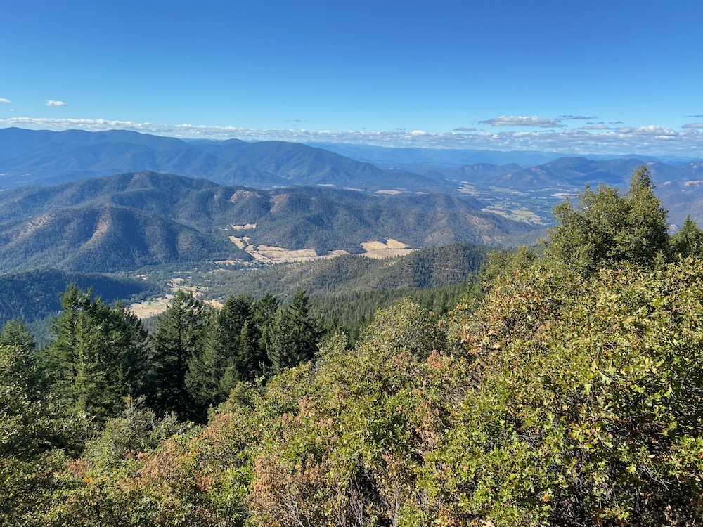
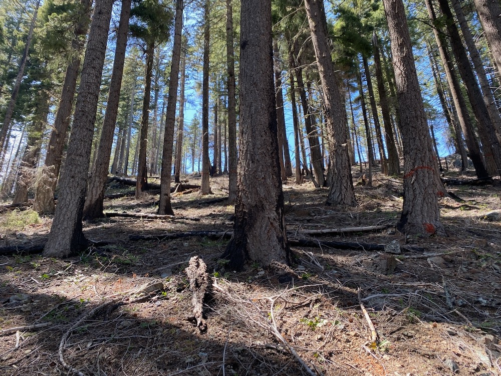
Taken from the summit of Tallowbox Mountain, this photo looks across the landscape proposed for logging as the Big Ben LSR Timber Sale, while the forested ridges in the background are proposed for logging in the Penn Butte and Late Mungers Timber Sales.
A 37″ diameter Douglas fir tree proposed for logging in unit 7-1 of the Late Mungers Timber Sale.
Currently, the Medford District BLM has proposed, but not fully approved the Late Mungers and Penn Butte Timber Sales above Williams and Murphy in the western portion of the Applegate Valley. These controversial timber sales propose logging old forest habitats in the Mungers Late Successional Reserve, an area designated specifically to protect northern spotted owl habitat and connectivity between watersheds. Yet, instead of protecting habitat, the project proposes logging old forests, degrading northern spotted owl habitat conditions and damaging the important connectivity that the area provides.
For two years, BLM timber planners designed the Late Mungers and Penn Butte Timber Sales under the provisions of the still unauthorized IVM Project and they did so in secret, refusing to provide any information to the public, despite repeated requests for information and project maps.
Although neither of these projects are currently approved, the agency has identified a March 2023 timber sale auction date for the Penn Butte Timber Sale, which has proposed logging 480 acres, producing an estimated 6.6 million board feet of timber. Meanwhile, the agency has identified a July 2023 auction date for the Late Mungers Timber Sale, which has proposed logging 312 acres totaling 2.5 million board feet.
For more information on the Late Mungers and Penn Butte Timber Sales, please review our recent blog posts and monitoring reports at the Applegate Siskiyou Alliance Blog.
Big Ben LSR Timber Sale
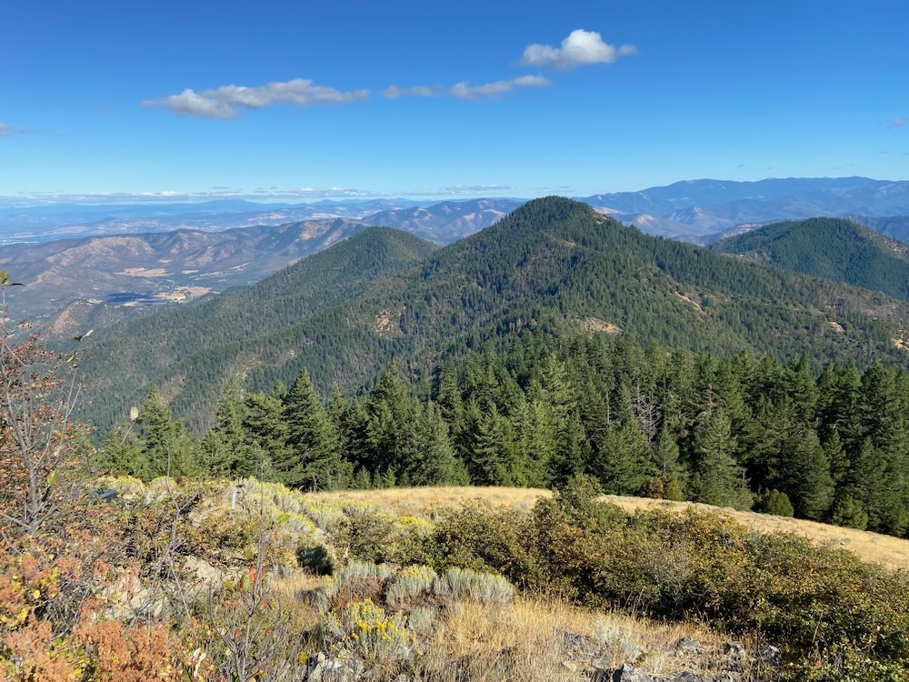
This view from Tallowbox Mountain to Ben Johnson Mountain and the Ruch area shows the forested habitats in the Middle Applegate watershed that may be included in the Big Ben LSR Timber Sale proposed for implementation by BLM in 2023. BLM has made no information about this project available despite repeated public requests.
Currently very little is known about the Big Ben LSR Timber Sale and the BLM is refusing to provide information on this sale to either the public or to elected officials. Working totally in the dark, the agency has refused to provide basic information on the location of timber sale units and is designing yet another Applegate Valley timber sale in secret, with no public accountability or input.
Despite repeated requests for information, the BLM is claiming that no information can be made publicly available, yet they have identified a September 2023 auction date. Currently the agency has identified approximately 700 acres of logging units, and 3.5 million board feet of timber proposed for logging in the Big Ben LSR Project.
With an auction date in less than a year, clearly more is known about this sale than the BLM will share; however, all we have been told is that “the project will be roughly located South of Applegate and Ruch, bounded by the Applegate River and Thompson Creek.”
Lower Sterling Mortality Salvage
This forest was logged in 2014 in the Sterling Sweeper Timber Sale which was proposed to promote so-called “forest health.” Ironically, the project logged large trees, created large canopy gaps, increased stand aridity, drought stress, and climate induced bark beetle activity, and sustained some of the largest bark beetle and fir borer mortality outbreaks in the Applegate River watershed in recent years. These stands were “salvage” logged in the recent Squishy Bug Timber Sale and are now being targeted again in the Lower Sterling Salvage Timber Sale.
Although not propose for implementation under the IVM Project, the BLM has proposed to auction off the Lower Sterling Mortality Salvage Timber Sale including units along the extremely popular Sterling Mine Ditch Trail without any public comment or involvement. The newly released Categorical Exclusion and Decision Record identifies 182 acres proposed for logging while the 2023 Timber Sale Plan identifies up to 1.1 million board feet proposed for removal.
The project is located in the Deming Gulch, Armstrong Gulch and Hukill Hollow watersheds, where repeated commercial thinning operations have increased drought stress by reducing canopy, damaging microclimate conditions and logging large, old trees. This in turn has triggering a series of large bark beetle mortality events in the area, which are now targeted for “salvage” logging.
Rather than encouraging “resilience” and “forest health,” these previous timber sales have become the center of the most pronounced bark beetle outbreak in the Little Applegate River watershed, and a similar story is also playing out on Thompson Creek, Ferris Gulch and in other portions of the Middle Applegate River watershed.
Following the Buncom Timber Sale of the 1990s and the Sterling Sweeper Timber Sale of 2014, many stands commercially thinned by the BLM on lower Deming and Armstrong Gulch have became hotter and drier, with more open canopies and more pronounced drought stress. Since 2016, previously thinned stands on lower Deming Gulch, Armstrong Gulch, Hukill Hollow and other areas around the region have sustained large bark beetle and flat headed fir borer outbreaks. Instead of experiencing increased resilience and vigor, many of the trees in these stands have been colonized by bark beetles or flat headed fir borers, creating vast swaths of beetle-killed Douglas fir and ponderosa pine between Sterling Creek and Wolf Gap.
This same area was also “salvage” logged in 2018 during the Squishy Bug Timber Sale, which was intended to both “salvage” economic value from beetle killed timber, and to reduce the scope and scale of the beetle infestation. Yet, apparently like the “forest health” timber sales implemented before the Squishy Bug Timber Sale, the logging had no positive effect on future bark beetle mortality and may have made things worse. Now, for the second time in less than five years, the BLM is “salvage” logging directly within their previous timber sale units due to significant bark beetle mortality following commercial logging operations.
Secret Timber Sales & the End of Collaboration on BLM Lands
Totaling 13.7 million board feet, these four timber sales are being proposed for implementation in our watershed without considering our concerns, soliciting meaningful public input or disclosing the project proposals until timber sales have been “finalized” and fully designed.
In the Applegate Valley, we hear a lot from our public land managers and elected officials about collaborative forest management, while at the same time we watch the BLM erode the process, eliminate all avenues for meaningful public collaboration and operate in secrecy. Open access to information is the foundation of collaboration and the BLM is consistently refusing to provide basic information on timber projects affecting the communities and watersheds of the Applegate Valley. While we work towards meaningful dialogue and sound environmental stewardship, the BLM continues in the opposite direction.
Please join Applegate Siskiyou Alliance as we defend the forests of the Applegate and the right of the public to participate in public land management! Support our work with a generous donation and speak for the forests that surround you!
A group selection logging unit along the East Applegate Ridge Trail. This unit would remove whole groves of large, fire resistant trees, including all those marked with white paint in this photograph.
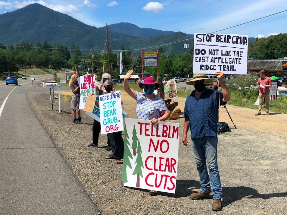
For the past three years Applegate Siskiyou Alliance has fought the Bear Grub Timber Sale, a large commercial logging project proposed by the Medford District BLM in the Wellington Wildlands, an over 7,000-acre roadless area west of Ruch, in the smaller Bald Mountain Roadless Area at the headwaters of the Little Applegate River, along the extremely popular East Applegate Ridge Trail, and many areas in between. This project proposed logging in the last remaining mature and old forest habitats surrounding Ruch, Little Applegate, and in the mountains above Talent, Oregon in the Rogue River Valley.
In October 2021, the Medford District BLM approved the Bear Grub Timber Sale and auctioned the sale off to the Timber Products Company, who had hoped to quickly begin logging; however, the BLM received 18 official Administrative Protests and was required to resolve these protests before the timber sale could be awarded and logging could begin. These included a detailed 52-page Administrative Protest submitted by Applegate Siskiyou Alliance and our partners at Klamath Forest Alliance. It also included numerous Administrative Protests from concerned residents in the Applegate Valley, who worked selflessly for over two years to stop this destructive timber sale.
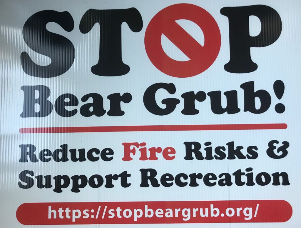
Thanks to all who participated in our campaign to STOP BEAR GRUB!
Thankfully, this past week the Medford District BLM rescinded the decision to proceed with the Bear Grub Timber Sale due to issues surrounding these Administrative Protests and an admission that the project’s impact on the Pacific fisher was not adequately analyzed.
In the BLM’s cover letter that came with their 102-page “Response to Protests,” they unjustifiably deny a multitude of other valid Administrative Protest points that should have been addressed more meaningfully. However, they also officially notified those that submitted Administrative Protests that the Bear Grub Timber Sale Decision Record will be rescinded and our protests were at least partially granted.
What this means, we are not entirely sure, but the BLM stated they will rescind the decision record and that the agency will “further review” the Environmental Assessment (EA) in regard to project impacts and the Pacific fisher. We believe that this controversial, environmentally damaging and counterproductive timber sale should be withdrawn all together. It was developed with little to no meaningful public input, in portions of the landscape that are wild, well loved, and would not benefit from the logging treatments proposed. The Bear Grub Timber Sale would directly impact the Wellington Wildlands, the East Applegate Ridge Trail, as well as the forests and human communities of the Applegate Valley — it should be canceled!
Another Bear Grub Timber Sale unit proposing to remove whole groves of large, overstory trees. The Bear Grub Timber Sale should be canceled to ensure future generations have access to wild places and a livable climate.
Please also consider supporting our work with a tax deductible donation. From Bear Grub to the IVM, to our tireless work to protect the Siskiyou Crest, Applegate Siskiyou Alliance is the most passionate advocate for the Applegate Siskiyous, and the only environmental organization focused entirely on protecting the wildlands of the entire Applegate River watershed. Your contribution will help us Stop Bear Grub!
The Penn Butte Timber Sale is leave tree or retention tree marked, meaning only those trees marked with yellow paint would be retained if logging operations take place. In this portion of unit 25-1A nearly every large Douglas fir tree would be logged, replacing fire resistant habitat and carbon rich forest with young, highly flammable vegetation with minimal habitat value or capacity for carbon storage.
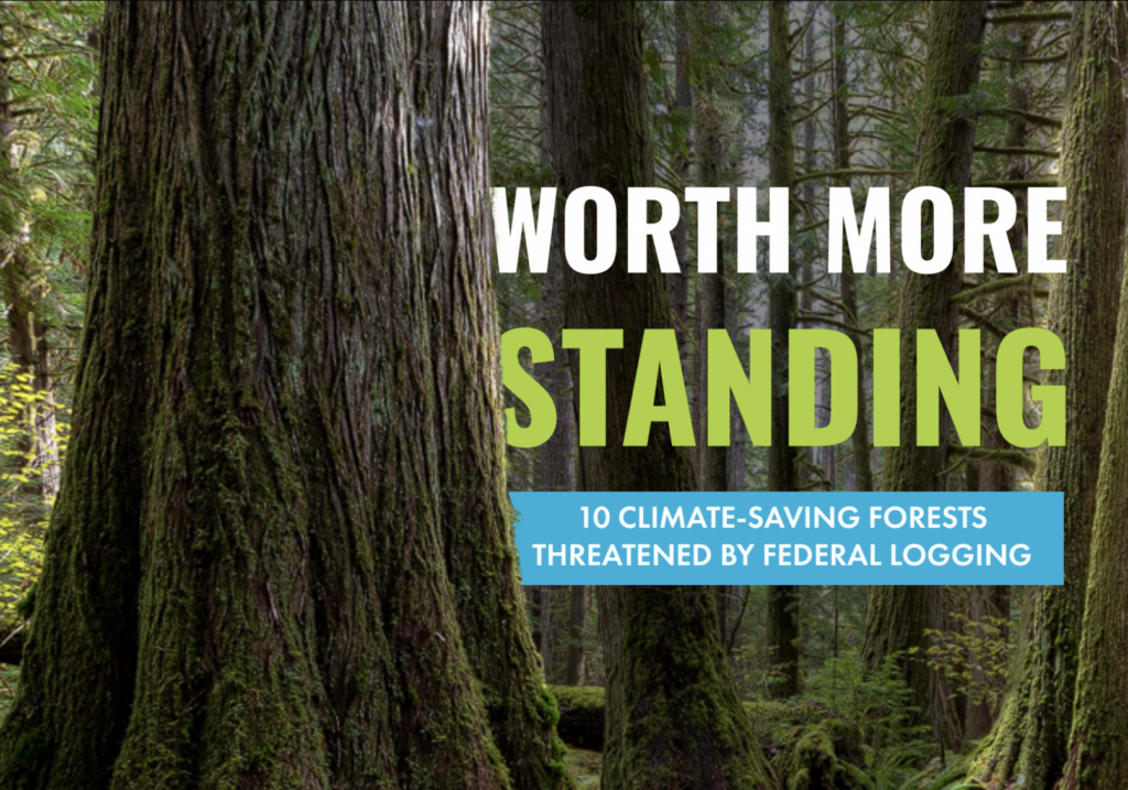
The Applegate Siskiyou Alliance (ASA) is proud to support and work as active members of the Climate Forest Coalition. The Climate Forest Coalition is a network of conservation organizations from across the country promoting the protection of mature, late successional and old-growth forests on federal lands as a natural and effective climate solution. The group is currently coordinating a national campaign to highlight the immediate threat old forest logging poses to our federal lands and our climate. We are also working to ensure that President Biden’s Earth Day Executive Order on forests is utilized to protect forests and store carbon on the landscape, as both a climate mitigation and adaptation strategy.
To that end, the coalition has recently published a report, Worth More Standing: 10 Climate Saving Forests Threatened by Federal Logging. In this report, activists and conservation organizations reviewed timber sales from across the country and unsurprising to us, they found some of the worst timber sales right here on the Medford District BLM. In fact, the Medford District BLM is the only land management agency in the country with two timber sales on this unfortunate list, including the IVM Project and the Poor Windy Timber Sale north of Grants Pass, Oregon.
ASA has worked extensively to oppose the IVM Project due to its impact on mature, late successional and old-growth forests, as well as its impact on northern spotted owl habitats, Late Successional Reserve (LSR) forests, Riparian Reserves, and carbon rich, climate mitigating forests, here in the Applegate Valley and throughout southwestern Oregon.
The large, unmarked tree in unit 7-1 and many others would be logged if the Late Mungers Project is approved by the Medford District BLM.
The IVM Project is a landscape scale logging proposal, focused on logging LSR forest, previously set aside to help recover populations of the threatened northern spotted owl and preserve its old forest habitat. It also eliminates numerous public involvement opportunities, public comment periods and current requirements for site specific environmental analysis and review. Simply put, the IVM Project is intended to authorize timber sales specifically in old forest habitats, without openly considering the potential impacts or the input of local communities.
The first timber sales proposed for implementation under the IVM Project are the Late Mungers and Penn Butte Timber Sale above Williams and Murphy, Oregon in the Applegate Valley. Reportedly, the BLM also intends to begin planning large timber sales in the Middle Applegate LSR, under the IVM’s administrative framework. The Middle Applegate LSR extends all the way from Williams to Ruch, on the forested slopes south of the Applegate River. Where exactly within this vast landscape the Middle Applegate LSR Timber Sale will be proposed is unclear, and just like the Late Mungers Project above Williams, the BLM is not required to engage or inform local communities of their plans until after they have been fully designed, marked on the ground and tentatively approved with an internal document called a “Determination of NEPA Adequacy.”
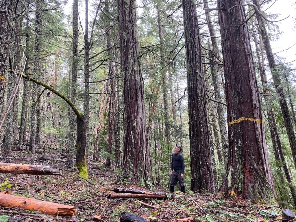
A 37″ diameter incense cedar proposed for logging in the Penn Butte Timber Sale above Williams, Oregon.
What is clear, is that forests in the Applegate, like forests across the country, provide important habitat values, watershed values, scenic values, and recreational opportunities. Forests also provide one of the most effective, natural climate solutions available to combat climate change and store carbon on federal lands. Research has demonstrated that old forests can act as climate and fire refugia, buffering ecosystems from the most damaging effects of climate change.
Permanently protecting and preserving these mature and old forests on federal lands is an important first step towards climate resilience and must be a significant priority if the Biden Administration is serious about its efforts to address climate change. Immediate action must also be taken by high level officials in the Biden Administration, the Department of Interior and the Department of Agriculture to cancel damaging old forest timber sales and logging projects like the IVM. The Medford District BLM will not stop logging old forests or work to ensure their timber sales are consistent with President Biden’s Executive Order unless they are forced to do so.
Every old tree in this old forest grouping is proposed for logging in unit 31-1B of the Penn Butte Timber Sale on Mule Gulch, a tributary of Mungers Creek in the Williams watershed.
We are asking President Biden and his cabinet level officials to carry out his campaign promises and meaningfully address the climate crisis by enacting permanent, enforceable administrative rules protecting all mature and old forests on federal lands. Please sign our petition to protect the forests of southwestern Oregon from the IVM timber grab. Speak for the trees and protect our climate! STOP THE IVM!
These 37″ and 40″ diameter Douglas fir trees are proposed for logging in unit 5-1 of the Late Mungers Timber Sale.
The Late Mungers Vegetation Management Project includes two large, industrial timber sales on the ridge system dividing the Applegate from the Illinois Valley. This ridge system is important for habitat connectivity and includes a large block Late Successional Reserve (LSR) forest set aside to protect habitat for the northern spotted owl.
Three large trees over 36″ diameter are proposed for logging in unit 5-1 of the Late Mungers Timber Sale.
Located in the mountains above Williams, Oregon, we have reported extensively on the Penn Butte Timber Sale, which proposes logging units on Mungers Creek, China Basin Creek, and Powell Creek above the pastoral Williams Valley and the small hamlet of Williams, Oregon.
However, another timber sale is also being proposed in the mountains between Murphy in the Applegate Valley, and Selma in the Illinois Valley. Known as the Late Mungers Timber Sale, the BLM has proposed logging a series of timber sale units totaling approximately 500 acres of LSR forest.
Recently, we visited the Late Mungers Timber Sale which targets mature, late successional and old-growth forest with heavy industrial logging. Although the treatments proposed throughout the timber sale will be damaging, this post will identify the worst units we have surveyed in the Late Mungers Timber Sale.
Unit 5-1
A 37″ diameter Douglas fir left unmarked by BLM timber managers and proposed for logging in unit 5-1 of the Late Mungers Timber Sale.
Unit 5-1 is located at the headwaters of both Black Canyon Creek and Grays Creek. These obscure tributaries flow north into the Applegate River from the forested ridgeline below Pennington Butte, downstream of Provolt, Oregon.
Small portions of the unit extend below road 38-5-6.1 in the Black Canyon Creek watershed, while other, more intact portions are located above the road and extend to a forested ridgeline, then into the headwaters of Grays Creek. These more intact portions of the unit include mature and late successional forest, along with a significant block of old-growth, surrounded on two sides by young, dense stands regenerating from previous clearcut logging operations. This corridor of old forest provides connectivity in an area otherwise devoid of mature and late successional habitat. Unfortunately, this corridor of habitat is also proposed for logging in the Late Mungers Timber Sale.
This entire old tree grouping, including trees up to 42″ diameter are proposed for logging in unit 5-1 of the Late Mungers Timber Sale.
Much of this beautiful stand is relatively open spaced, with groupings of mature and old-growth trees growing in a diverse clump formation. The stand contains important closed forest habitat, dominated by large, old trees between 20″ and over 50″ diameter, including Douglas fir, ponderosa pine, and sugar pine. Between the large conifer groupings a well developed mosaic of live oak and madrone woodland has colonized the canopy gaps and matured into a diverse and productive mixture of habitat types.
At the headwaters of Grays Creek, the unit contains mature, mid and late successional forest habitats, including closed stands of pine and fir targeted for aggressive group selection logging and heavy commercial thinning operations.
A 30″ diameter, open grown ponderosa pine proposed for logging in unit 5-1 of the Late Mungers Timber Sale.
The proposed tree removal mark throughout this unit is extremely heavy handed and will damage LSR forests, late successional habitat values, habitat connectivity, and habitat complexity. In many locations, trees between 30″ and 45″ diameter have been identified for removal, and in other locations, entire old forest groupings dominated by large, carbon and habitat rich trees are proposed by the BLM for removal. This includes a number of large, old Douglas fir trees up to 45″ diameter and open-grown ponderosa pine trees up to 30″ diameter. (Note: The Late Mungers Timber Sale is “leave” or “retention tree” marked, meaning only trees marked with red or yellow paint would be retained in timber sale units. Trees that will be logged are not marked with spray paint.)
Many of the trees targeted for removal exceed the 36″ diameter and 156-year-old tree removal limits identified in the BLM’s 2016 Resource Management Plan (RMP). The removal of these trees is a violation of existing management plans, is inconsistent with LSR management and will impair northern spotted owl habitat values for decades to come.
Unit 5-1 contains important old forest habitat that should be retained as high quality northern spotted owl habitat, for its carbon storage, and for its naturally high levels of fire resistance.
Unit 7-1
The 32″ diameter unmarked Douglas fir tree is proposed for logging in unit 7-1.
On the northern slope of the ridgeline dividing Powell Creek from Murphy Creek, unit 7-1 is located at a higher elevation than most of the Late Mungers Timber Sale, and extends into a more productive montane forest of Douglas fir and scattered white fir at the headwaters of Murphy Creek. The stand contains mature to late successional forest components, large old trees, a closed canopy, and patches of structural complexity.
Unit 7-1 surrounds a large block of nesting habitat for the northern spotted owl, and although not identified as such by the BLM, it appears to support nesting habitat as well. Given the relatively productive forest conditions, this stand will continue developing habitat complexity, accumulating and recruiting large snags, downed wood and living trees through forest succession and time. The logging proposed in the Late Mungers Timber Sale will only disrupt this process, degrade habitat conditions, and remove important habitat elements.
This stand is also relatively fire resistant with a high canopy, a dominance by large trees, and relatively cool, moist habitat conditions. The canopy shading provided by large old trees also serves to suppress understory growth, and in so doing, naturally reduces fire risks.
The dramatic canopy cover reduction, the removal of large, fire resistant trees, and the alteration of microclimate conditions proposed in the Late Mungers Timber Sale will trigger both stand drying and the development of dense, woody understory fuels as young, highly flammable trees and shrubs regenerate and fill in the canopy gaps created by group selection logging and heavy commercial thinning operations.
The BLM has proposed new road construction on this beautiful ridgeline dividing Powell Creek from the Applegate Valley.
Additionally, roughly one mile of new road is proposed for construction on the beautiful ridgeline above and across the steep mountain slopes of unit 7-1. This new road will impact intact habitats, increase noxious weed spread, create excessive erosion, and encourage illegal OHV use, while facilitating commercial logging that will degrade forest habitats, increase fire risks and contribute to the climate crisis.
Unit 22-1
A 38″ diameter Douglas fir proposed for logging in unit 22-1 of the Late Mungers Timber Sale.
Unit 22-1 is located at the headwaters of Murphy Creek in an area heavily logged decades ago. Much of unit 22-1 is a plantation forest recovering from previous logging treatments, yet the narrow eastern portion of the unit contains a beautiful mature and mid-successional mixed conifer forest with snags, downed wood, some large dominant trees, and generally complex forest habitats that have never been logged. The soils are extremely rocky with some impressive rock outcrops and very little understory growth. Understory fuel development is currently moderated by overstory canopy growth, keeping fire risks to a minimum. The lower portion of the stand also contains a beautiful mountain spring at the head of Murphy Creek.
We found a few 30” diameter trees and a large 38″ diameter tree identified for logging in this unit, and if implemented, enough canopy would be removed through logging to both trigger an understory shrub response and significantly degrade habitat conditions for the northern spotted owl.
Unit 15-1
A 36″ diameter, open-grown Douglas fir growing in unit 15-1 in the Deer Creek watershed that is unmarked by the BLM and identified for logging.
Unit 15-1 straddles the ridgeline between Deer Creek and Murphy Creek, and contains some large, old trees over 50” diameter. The south-facing slopes in the Deer Creek watershed contain mixed conifer and hardwood groves with intact stands of live oak and madrone woodland. Patchy, low density groves of large, fire-resistant conifer species growing as islands among the canopy of hardwood trees that have colonized this harsh, ridgetop since the last mixed severity fire.
The forest and woodland in unit 15-1 do not need fuel reduction or forest health treatments and are maturing nicely without intervention. Despite minimal overstory conifer growth, trees up to 36” are identified for removal in the stand, removing some of the most fire resilient, mature trees to pierce through the canopy of hardwood forest.
This unit also extends onto the north-facing slope which contains a significant hardwood component and younger stands of Douglas fir.
Conclusion:
The logging proposed in the Late Mungers Timber Sale would dramatically reduce canopy cover, remove large, fire resistant trees, alter microclimate conditions, degrade habitat complexity, damage northern spotted owl habitat, reduce old forest, snag and downed wood recruitment, release abundant stored carbon and increase fire risks.
A 36″ diameter Douglas fir proposed for logging in unit 7-1.
Recent research by scientists at Oregon State University has demonstrated that the logging and wood products industry are the biggest producers of greenhouse gas emissions in the state of Oregon (Law. 2018). The type of old forest logging proposed in the Late Mungers Project is particularly troubling because it proposes to transform our beautiful old forests from important carbon sinks into dangerous carbon sources. The Medford District BLM is steadily converting carbon rich old forests across southwestern Oregon into carbon bombs that will only further compound current climate impacts.
The agency is also steadily converting fire resistant old forest, with currently cool, moist habitat conditions, into hot, dry, windswept habitats dominated by young, highly flammable regeneration. The removal of large, old trees and excessive levels of canopy cover (to as low as 30%) would increase fire risks on BLM lands and threaten nearby communities. The large, dominant trees proposed for logging in the Late Mungers Timber Sale and the excessive canopy reduction identified on the ground will dramatically increase fire risks on both the stand and landscape scale.
The relatively open, healthy stand conditions in unit 22-1 at the headwaters of Murphy Creek are proposed for logging in the Late Mungers Timber Sale, including the large 30″ diameter Douglas fir in the foreground of this photo.
The Late Mungers Timber Sale and the old forest logging it proposes is a violation of President Biden’s Executive Order on forests and an unacceptable impact to the mature and old-growth forests that stabilize our climate, maintain fire resilience, and safeguard our clean water. We ask the Medford District BLM to comply with President Biden’s Executive Order on old forest and climate, to become part of the solution, and to cancel the Late Mungers Project!
The Medford District BLM recently approved the Integrated Vegetation Management for Resilient Lands (IVM) Project, a purposefully misleading attempt to conflate their proposals for heavy industrial logging with so-called “forest resiliency” work.
At our recent Provolt Rally, a sign was displayed by a particularly astute local resident declaring the IVM, Intentionally Very Misleading — we could not agree more!
To sign our Late Mungers Petition follow this link.
Unit 26-1A of the Penn Butte Timber Sale burned at low severity in the recent Spencer Creek Fire, but is proposed for logging to “increase fire resilience.” Only the tree marked with red paint would be retained if logging was to occur.
The Applegate Siskiyou Alliance has been tracking and actively opposing the IVM Project since its initial proposal in 2019, and now that the IVM has been approved, the BLM has proposed to begin implementation of the IVM Project in the mountains between Williams and Murphy, Oregon in the Applegate River watershed.
This first project, called the Late Mungers Vegetation Management Project, includes the Late Mungers and Penn Butte Timber Sales. Located in a Late Successional Reserve (LSR) forest designated to protect and develop old forest habitat for the northern spotted owl and other forest dwelling species, these timber sales extend across the Mungers Creek and Powell Creek watersheds above the Williams Valley, across numerous tributaries of the Applegate River, including Murphy Creek, and small portions of the Deer Creek watershed above Selma. Together the timber sales would log 8 million board feet of timber on 800 acres of LSR forest.
Old, closed canopy forests like this in unit 25-1A in the Penn Butte Timber Sale have been characterized by the BLM as “overly dense” and targeted with heavy commercial logging, down to 30% canopy cover.
Although the BLM claims these projects will build fire resilience, restore fire-adapted stand conditions, reduce the relative abundance of “overly dense” closed canopy forest stands on the landscape scale, and develop northern spotted owl habitat through heavy industrial logging, we strongly disagree.
We disagree with the following BLM claims for the Late Mungers and Penn Butte Timber Sales:
1. The treatments proposed in the Late Mungers and Penn Butte Timber Sales are necessary, beneficial or are intended to increase fire resilience;
2. The logging treatments proposed will actually increase fire resilience on the stand or landscape level;
3. The logging treatments proposed are actually targeting “overly dense,” forest stands that are “departed” from the range of historic variability; and
4. The logging treatments proposed will develop complex forest habitat for the northern spotted owl through large tree removal and heavy canopy reduction.
For over a month, we have been out monitoring timber sale units throughout both the Penn Butte and Late Mungers Timber Sales. During that time we have found many examples of fire resilient, mature, late successional or old-growth forests proposed for logging; however, unit 26-1A is among the most egregious examples.
Unit 26-1A
The open, fire-adapted stand conditions in unit 26-1A four years after the Spencer Creek Fire. Only the trees marked with red paint will be retained if the proposed Penn Butte Timber Sale is implemented.
Unit 26-1A contains mature, montane fir forest located at roughly 5000′ elevation on the eastern face of Morgan’s Buckhorn and at the headwaters of Powell Creek. The forest in unit 26-1A burned at low severity in the 2018 Spencer Creek Fire, a complex of three small fires that burned approximately 200 acres in the mountains between Murphy, Williams, and Selma.
In unit 26-1A the fire backed downhill and burned moderately beneath groves of large, relatively open spaced Douglas fir. The fire burned through duff layers, downed wood, young understory trees and stump sprouting shrub species without altering overstory canopy conditions. The stand’s closed canopy sheltered the area from strong winds and intense sunlight, and suppressed understory growth enough to naturally moderate fuel loading. These factors combined with favorable weather conditions to limit fire intensity in unit 26-1A, maintaining fire-adapted stand conditions and rejuvenating understory vegetation, including young trees, shrubs and herbaceous species.
Four years later the forest floor contains very little dead material, virtually no significant fine fuel, and fresh, green growth, including young shrubs, herbaceous flowering growth and a new cohort of Douglas fir seedlings. The current mixture will remain largely unburnable for the next few years, and having survived the last fire unscathed, the overstory fir trees maintain high levels of fire resistance.
A portion of unit 26-1A is located on the ridgeline dividing Powell Creek in the Williams Creek watershed from Deer Creek and the Illinois River watershed. The fire burned at low severity beneath large, old trees and now BLM intends to log many of the survivors.
Ironically, despite the extremely positive fire effects sustained during the 2018 Spencer Creek Fire, the agency has decided that the fire did not kill enough trees in this stand or create the arbitrary stand conditions that BLM claims are most beneficial. The agency is now proposing to log off many of the large, fire resistant trees in unit 26-1A that survived the 2018 Spencer Creek Fire.
Utilizing a so-called “Ecosystem Resilience-open” prescription, the agency has proposed logging, large, fire resistant trees over 30″ diameter and reducing canopy cover to as low as 30% in this stand. This would require removing more than half of the stand’s living trees, and rather than restoring habitat conditions, these treatments would replace functional closed canopy forests with a mere scattering of open grown trees. The logging proposed would eliminate protective cover important for wildlife species, including the northern spotted owl, degrade canopy conditions, eliminate significant habitat complexity and contribute to microclimate alterations that will dry out forest stands, increase temperatures, and regenerate highly flammable young trees and shrubs where fire resistant forest once stood.
Another view of unit 26-1A following the Spencer Creek Fire. Only the few trees marked with red paint in this photograph would be retained if logging occurs.
Unit 26-1A is “leave” tree or “retention” tree marked, meaning only those trees marked with red paint will be retained if the Penn Butte Timber Sale is implemented and old forest logging occurs. The proposed logging would degrade this currently intact, beautifully fire-adapted forest and undermine the benefits of the Spencer Creek Fire by removing fire resistant trees and damaging the natural post-fire rejuvenation and new cohort of young conifer seedlings sprouting up after the fire. The logging will also impact sensitive fire-affected soils and spread noxious weeds in currently intact fire-adapted, native plant communities.
Unit 26-1A does not need “treatment” to maintain fire-adapted forest conditions, benefit the northern spotted owl or enhance native plant communities, — the 2018 Spencer Creek Fire naturally achieved these goals.
The logging treatments proposed in unit 26-1A of the Penn Butte Timber Sale have no credible biological justification, just clear economic motivations. Despite the BLM’s rhetoric regarding “forest restoration” and “forest resilience,” the Penn Butte and Late Mungers Timber Sales are the latest and perhaps most brazen examples of industrial, old forest timber sales masquerading as restoration projects on public lands in southwestern Oregon.
Open, fire-adapted forest proposed for logging in unit 26-1A of the Penn Butte Timber Sale.
To sign our Late Mungers Petition follow this link.
You can find more information on this project on recent Applegate Siskiyou Alliance blog posts. The public comment period ends on June 28.
The IVM Project is a massive, landscape-scale logging proposal recently approved by the Medford District BLM in southwestern Oregon. The IVM Project would allow for the implementation of up to 20,000 acres of commercial logging and 90 miles of new road construction in the next ten years, with virtually no site-specific environmental analysis, scientific review or public input. It would also specifically target Late Successional Reserve (LSR) forests set aside to protect habitat for the northern spotted owl and other species dependent on mature or old-growth forests.
Mungers Creek may be the wettest watershed in the Applegate River basin, but is being characterized by the BLM as dry forest to encourage heavy old forest logging in lush forest of towering Port Orford-cedar and Douglas fir.
These mature and old-growth forests are increasingly rare and increasingly important for the habitat they provide, the carbon they store, and the watershed values they protect. They are also increasingly threatened as the Medford District BLM proposes to implement the IVM Project.
Unfortunately, the BLM has proposed to begin implementation of the IVM Project with the Penn Butte and Late Mungers Timber Sales in the mountains between Murphy and Williams, Oregon. These timber sales are located, at least partially, in the rain forests of the Applegate, on Mungers Creek and upper Powell Creek. On the western margin of the Applegate River watershed, these drainages receive abundant rainfall, and dense coastal fog often pours over the ridgeline from the Illinois Valley in the winter months. This fog and rain tends to settle in these forested canyons, sustaining lush habitats indicative of the Pacific Northwest, but with a Siskiyou Mountain flare.
Forests of the endemic and threatened Port Orford-cedar grow in upper Williams Creek, along with productive forests of Douglas fir and tanoak. These habitats support plant communities not commonly found in the dry forests of the Applegate Valley, including a coastal understory shrub association of evergreen huckleberry, red huckleberry, salal, and vine maple.
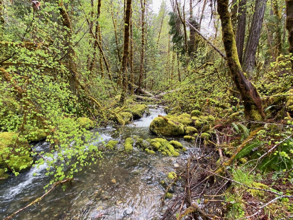
Lush and beautiful Powell Creek.
Yet the BLM portions of Mungers Creek and upper Powell Creek are not just lush, carbon-rich forests; together, these drainages also contain one of the largest blocks of old forest remaining in the Mungers LSR. This large, relatively intact block of moist forest habitat is particularly important for the northern spotted owl, the Pacific fisher, the Humboldt marten and other wildlife species. Unfortunately, this same area contains a significant concentration of commercial logging units in the Penn Butte Timber Sale.
Recently, we have been out monitoring these timber sale units and below is what we found.
Units covered in this post
Units in yellow polygons are “Ecosystem Resilience-Open” treatment areas where canopy cover can be removed down to 30%, while the green polygons are “Near Term” treatment types where 60% canopy cover would be retained. The polygons with light green spots are BLM identified nesting habitats for the northern spotted owl.
Unit 25-1A
Every large Douglas fir in this photograph would be targeted for removal in unit 25-1A. Located in Late Successional Reserve forest, where the agency is directed to protect old forest habitat for the northern spotted owl, the agency is instead targeting significant old forest stands for heavy industrial logging.
Unit 25-1A is part of a beautiful and highly diversified forest straddling the ridgeline between Mungers and Powell Creek, at the heart of the Mungers LSR. The unit spills over the ridge into both watersheds and contains mature and late successional forest habitat proposed for logging “treatments” that would fragment forest canopy and remove large, fire resistant trees throughout this spectacular stand.
The south-facing slopes support relatively dry forest associations of pine, fir, incense cedar and madrone, draining into the North Fork Mungers Creek. The north-facing slopes on the other hand, contain more mesic conditions. These north-facing forests contain beautiful groves of Douglas fir, incense cedar, tanoak and madrone, with thickets of young Port Orford-cedar in slight topographical depressions. This stand contains a much higher percentage of large incense cedar than other units in the Penn Butte Timber Sale and represents a forest association that is relatively unique in the planning area.
Although not identified as such on BLM maps, these forests also contain all the necessary characteristics for northern spotted owl nesting habitat and should be withdrawn from commercial entry in the Penn Butte Timber Sale. Additionally, the south-facing slopes and the remainder of unit 25-1 contain important connectivity habitat and unidentified nesting habitat. These stands tie together high quality blocks of northern spotted owl habitat in both upper Mungers and upper Powell Creek.
A large Douglas fir unmarked and identified for removal in unit 25-1A. Notice the relatively open forest structure. The unmarked 36″ diameter Douglas fir tree is targeted for logging in the Penn Butte Timber Sale.
Logging treatments in unit 25-1A and across the larger landscape will fragment habitat connectivity, reduce suitable habitat available for the northern spotted owl and other wildlife species and degrade the old forest values remaining in the Mungers LSR, in both the long and short term.
Although unit 25-1A contains spectacularly beautiful forest habitats, the unit is also proposed for some of the heaviest logging prescriptions authorized under the IVM Project. Ironically, called “ecosystem resilience-open” prescriptions, these treatments allow significant canopy removal down to as low as 30%. Due to the heavy prescription proposed and the old forest targeted for logging, this unit likely contains the largest concentration of trees over 30” diameter proposed for removal in the entire Penn Butte Timber Sale, and the treatments proposed are inconsistent with both species recovery for the northern spotted owl and the mandates of the BLM’s 2016 Resource Management Plan (RMP), which promotes the development of additional northern spotted owl habitat in the LSR forest network.
A 37″ incense cedar identified for removal in unit 25-1A of the Penn Butte Timber Sale. If the BLM implements the Penn Butte Timber Sale, old forest habitat would be heavily degraded throughout this unit and throughout the watersheds above Williams and Murphy, Oregon.
The old trees in unit 25-1A are either relatively open grown or grow in complex clumps or groupings of older, more dominant trees. Neither these groupings or individual dominant trees should not be altered by industrial logging, as they currently provide the most important late successional forest characteristics within this beautiful stand.
Healthy groves of hardwoods such as madrone and some tanoak form a secondary canopy, clumps of young Port Orford-cedar also add to the structural diversity and canopy layering, while scattered old snags are distributed throughout the stand, and large downed wood lies strewn across the forest floor, creating diversity, holding moisture and providing structural complexity.
Unit 25-1A needs no “treatment” to maintain its health, the area is not unnaturally dense, and the area does not sustain a heavy fuel load; however, these productive old forests contain abundant standing timber volume and BLM intends to convert large portions of this old forest into lumber for local mills. This would be done at the expense of old forest values, fire resilience, wildlife habitat, the area’s spectacular scenic qualities, and nearby local communities.
A 30″ and 36″ incense cedar identified for removal in unit 25-1A.
Unit 25-1A demonstrates everything that is wrong with the Penn Butte Timber Sale. This unit, along with the entire Penn Butte Timber Sale, should be withdrawn and the area’s old forests should be maintained for the purposes the Mungers LSR was designated for, namely, the protection, not the destruction of old forest habitat.
Unit 25-1B
The large old trees in this photograph are proposed for logging in unit 25-1B of the Penn Butte Timber Sale.
Directly below unit 25-1A and directly below road 38-5-15, unit 25-1B is located on a south-facing slope at the headwaters of North Fork Mungers Creek. This stand contains relatively productive forests of Douglas fir, ponderosa pine, sugar pine, incense cedar and madrone. Old, dominant trees grow in natural groupings or as individual trees scattered throughout the stand with a younger, but mature cohort of fir, cedar and madrone filling in canopy space.
Like other units we have visited, unit 25-1B was previously thinned in the Deer Willy Stewardship Project, which focused on small diameter tree removal and non-commercial fuel reduction treatments. According to the analysis that led to this project, the treatments were focused on maintaining large trees, restoring habitat conditions and reducing fuel loads. While these objectives may have been met to various degrees in the original treatments, the BLM is now treating these previous projects as “pre-commercial” thinning in preparation for the Penn Butte Timber Sale and it’s overstory tree removal.
The heavy commercial logging proposed in unit 25-1B is counterproductive and inconsistent with the goals and objectives of the of the previously approved Deer Willy Stewardship Project, which was implemented by the Lomakatsi Restoration Project in roughly 2010. By logging off trees previously targeted for retention and “release,” previous stewardship efforts are being undermined and reversed. Additionally, fire risks and understory fuel loading will increase as dense, woody vegetation fills in the group selection clearcuts and canopy gaps created by commercial logging.
The targeting of previous so-called “forest restoration” work and non-commercial thinning done by groups such as Lomakatsi Restoration Project, for industrial logging by the BLM, makes you wonder if all the “forest restoration” work being done is just setting up the BLM for future logging operations, and are in-fact being treated by BLM as pre-commercial thinning treatments intended to facilitate the more efficient removal of old forest habitat at a later date. In this case “restoration” is a guise for commercial timber production and industrial timber management on federal lands.
Large, dominant fir and cedar proposed for removal in unit 25-1B of the Penn Butte Timber Sale. This unit was previously subjected to non-commercial thinning in the former Deer Willy Stewardship Project and is now being targeted for commercial, old forest logging.
This unit is also located within the largest block of relatively connected old forest habitat in the Mungers LSR and is vital for the connectivity of old forest habitats in the Mungers and Powell Creek watersheds. It also contains significant late successional forest characteristics, and many of the area’s important habitat features would be removed if the proposed logging treatments occur.
Using the heavy handed “ecosystem resilience-open” prescriptions, the BLM is proposing significant canopy reduction, converting this relatively closed forest to a mere scattering of trees. Canopy cover could be reduced to as low as 30% and many dominant, old trees over 30” diameter would be removed. Such activity provides no benefit to the Mungers LSR, and instead will damage and degrade the old forest values this area was designated to protect.
Units 25-1C, 25-1D, 25-1E, 25-1F and 25-1G
A grouping of large, fire resistant Douglas fir trees unmarked and identified for removal in unit 25-1G of the Penn Butte Timber Sale.
Unit 25-1 is a massive sprawling complex of commercial logging units, spread across the Mungers Creek watershed. Each sub-unit contains slightly different stand conditions and management histories. Some sub-units contain more large, old trees, and others contain more dense stands reproducing after previous logging operations. Some are located high on the ridgeline, on relatively exposed south-facing slopes, while others are located deep in the North Fork Mungers Creek canyon, adjacent to nesting, roosting and foraging habitat for the northern spotted owl.
Most of these units are mature and mid-successional stands with scattered old, dominant trees. They include forest of Douglas fir, sugar pine, ponderosa pine, the occasional incense cedar, wide branching live oak and beautiful madrone. The prescriptions in the Penn Butte Timber Sale throughout this area are among the most intensive in the entire timber sale area and include both large tree removal and group selection logging.
A group selection cut in unit 25-1G of the Penn Butte Timber Sale. Every tree in this photograph would be removed if the project moves forward.
Group selection logging is a form of staggered clearcut forestry that would remove whole groves of mature, dominant trees. The goal is to create openings and dense young stands of regeneration. According to BLM analysis these treatments will increase fire risks, future fire intensity and resistance to control. Contrary to the rhetoric surrounding the IVM Project and the Penn Butte Timber Sale, these treatments will increase fire risks, reduce habitat quality, and degrade old forests habitats, while sacrificing our LSR forests to the timber industry.
Unit 25-2
A large, open-grown Douglas fir identified for removal in unit 25-2.
Unit 25-2 contains mature to mid-successional stands dominated by Douglas fir and white fir, with scattered populations of large, old sugar pine and Douglas fir. In an effort to create very open stand conditions under the “Ecosystem Resilience-Open” prescription, a number of large, old, open grown trees are targeted for removal.
Additionally, the more closed, north-facing slopes would be dramatically opened through group selection logging and commercial thinning prescriptions, converting currently mid-successional, closed canopy stands into disturbed, open canopied stands that will soon fill in with highly flammable young vegetation.
Unit 25-3
The large old trees in this photo are nearly all within 60′ of the large sugar pine marked with double red bands and would be removed in unit 25-3.
Unit 25-3 contains closed canopy stands of mature and mid-successional forest. These stands contain mostly Douglas fir and white fir between 24” and 40” in diameter, with scattered old-growth sugar pine and Douglas fir trees over 5 feet thick.
The south-facing slopes above road 38-6-25.5 drain into the North Fork Mungers Creek and contain closed canopy, but relatively open spaced stands. In these areas, canopy shade is suppressing understory fuel development and has created an equilibrium where overstory growth dramatically minimizes young, shrubby in-growth and conifer regeneration. Dominated by large trees, the stand is naturally fire resistant, was previously treated for small diameter fuels and is in the process of developing late successional forest conditions, heterogeneity, large diameter snag habitat and coarse downed wood.
The north slope of the unit is more productive, but was also historically more heavily logged. It also naturally contains a higher percentage of white fir than surrounding habitats, due to the protection and microclimate conditions associated with less solar exposure. Currently, old-growth groupings, groves and scattered individual sugar pine, ponderosa pine and Douglas fir trees grow above a more uniform layer of mid-successional forest and pole stands. These mid-successional cohorts have regenerated after previous BLM logging projects and are the most dense where previous canopy removal occurred.
The logging prescriptions proposed for unit 25-3 have been identified as “near term” treatments intended to maintain northern spotted owl habitat and 60% canopy cover. The agency is implementing this prescription with a slightly altered form of group selection logging, where, in theory, all trees up to 36” for Douglas fir and pine species and 40” for white fir would be removed within a 60’ radius of trees marked for retention. Trees marked for retention and radial tree removal have been identified on site with double red bands of paint and are widely scattered throughout the unit.
Will the loggers decide which trees are felled or will the BLM mark “reserve” trees over 36″ diameter for retention in unit 25-3? Using a “prescription by designation” approach, the BLM is currently proposing to allow the timber industry to interpret the prescription themselves by identifying trees over 36″ and outside a 60′ radius from double red banded trees for retention. The public is concerned this will lead to mismanagement, overcutting and illegitimate tree removal.
Currently, the BLM claims this unit has been fully marked, but trees both within the 60’ radius and over the stated diameter limit are not marked for retention. This includes trees up to 45” diameter with significant old-growth characteristics.
At a recent BLM field trip, the agency identified the area as a “prescription by designation” unit. This means that the loggers themselves will determine which trees are removed within the currently completely undefined 60′ radius from marked leave trees. Apparently, the BLM believes the loggers will measure the 60′ radius accurately, judiciously measure each individual trees diameter, and determine which trees will be removed with no bias, no self interest and no commercial value in mind.
When the public questioned the BLM on the recent field trip, why the BLM could not just mark all “reserve” trees beyond the stated diameter limit and identify the 60′ radius on the ground, BLM silvicultural staff told us that they did not want to take the time to mark the trees for retention and that the paint they used was prohibitively expensive. Apparently, according to BLM silvicultural staff, large old trees in LSR forest are not worth the time it takes or the aesthetically unpleasing paint necessary to “reserve” them from timber harvest. Concerned residents and the public would disagree.
In some places these radial group selection cuts appear to be specifically designed to target significant concentrations of large trees for removal within 60’ of a massive old pine tree. This includes stands where an old-growth sugar pine would be cleared out to 60’, allowing dozens of large Douglas fir and ponderosa pine trees between 20” and 36” (or more) to be removed. In other locations, smaller Douglas fir trees have been marked for retention, allowing a dozen or more trees of similar or even greater size to be removed in the 60’ radial group selection cut.
We have significant concerns regarding the size of trees targeted for removal in this unit, the impact this removal will have on microclimate and stand conditions following commercial logging operations, and the economically motivated tree removal throughout the Late Mungers Project Area and Mungers LSR. The removal of large old trees in this unit will dry out forest stands and trigger an aggressive understory shrub response, increasing fire risks and fuel loading with dense, young vegetation and logging slash. It will also degrade habitat conditions for the northern spotted owl by reducing the density of large, dominant trees, reducing canopy cover, impairing habitat complexity and disrupting snag and downed wood recruitment.
The current marking strategy will lead to the removal of large, old trees that exceed the upper diameter limit identified in the 2016 RMP and the IVM Project Decision Record. We cannot support, and the BLM cannot justify, allowing the logging company themselves to interpret and implement BLM logging prescriptions on the ground.
We also believe that removing white fir trees up to 40” in diameter in LSR forest is damaging to the values intended for protection in the Mungers LSR and cannot be justified, especially in stands like 25-3, where the north-facing slope recruits and sustains white fir, as a natural component of the forest community. Unit 25-3, the Late Mungers Project and the entire IVM Project should be canceled to protect public involvement, old forest values, and northern spotted owl habitats.
Unit 30-2
These large, open grown trees including a 35″ diameter Douglas fir are targeted for removal in unit 30-2. Creating an isolated, mature tree grouping in habitat dominated by live oak woodland, these trees provide important habitat conditions and structural complexity. These are also among the most fire resistant trees in the stand, but would be removed in the Penn Butte Timber Sale.
The Mungers LSR was designated specifically to maintain connectivity between old forest habitats and northern spotted owl populations in the Applegate and Illinois River watersheds. In the upper Mungers and Powell Creek watershed connectivity between old forests is relatively high, and some of the most intact forest habitats remaining in the Mungers LSR can be found.
Unit 30-2 contains two separate, but nearby stands at the headwaters of North Fork Mungers Creek. These uncut, mid-successional forests contain a scattering of large, old-growth trees directly adjacent to one of the largest blocks of northern spotted owl nesting habitat in the area. The forest in unit 30-2 provides dispersal habitat between watersheds and plays a very important role in the connectivity between old forest habitats in the Mungers LSR.
The northern portion of unit 30-2 contains largely mid successional Douglas fir groves between 18” and 40” diameter. The canopy of these large overstory trees pierce through a dense layer of multi-stemmed live oak that dominates the upper portions of the slope. Growing near the ridgeline and extending deep into the interior of unit 30-2, these live oak stands and the mid-successional Douglas fir groves scattered within them, have clearly regenerated from previous wildfires of relatively high severity. The now maturing groves of Douglas fir found within this unit, break up the live oak woodland, providing important structural diversity and high levels of fire resistance.
Douglas fir trees up to 35” diameter have been identified for removal and whole groves near the ridgeline are proposed for group selection logging, which proposed removing groupings of trees between 24” and 35” in diameter and up to two acres in size.
Logging this unit would also require new road construction, built across a previously unimpacted ridgeline. The development of this logging road will impact forest soils, increase the potential for noxious weed spread, facilitate illegal OHV use, damage existing native plant communities, and require the removal of many trees and forest canopy. This additional tree removal will increase the effect of stand drying, solar exposure and accelerated windspeeds. These influences will in turn desiccate fuels, alter microclimate conditions and regenerate dense woody vegetation, creating potentially more explosive fire spread and higher severity fire effects.
The southern section of unit 30-2 also clearly regenerated from the same historic wildfire event. Located lower on the slope, the area contains a few more legacy trees than the higher, drier northern section. The large old trees in this stand appear to have survived the historic, mostly stand replacing fire and now, provide continuity between the old and the new.
Half of this spectacular old tree grouping is proposed for removal in unit 30-2 of the Penn Butte Timber Sale. The unmarked ponderosa pine proposed for logging is 33″ diameter, open-grown and likely very old. Together these two trees create a complex, interlocking old forest canopy and have survived past wildfires and disturbance processes. As “legacy forest structures,” these trees may contain the most important late successional forest characteristics in all of unit 30-2.
By surviving the previous wildfire, these trees became the foundation for both forest regeneration and future forest complexity. Widely scattered and relatively open grown, these large old trees grow amongst a mature, mostly even-aged cohort of Douglas fir between 20” and 30” diameter. Creating more closed stand conditions as it matures, this cohort is now suppressing understory growth, maintaining less flammable microclimate conditions, creating canopy shade, and higher levels of natural fire resistance. As this stand continues to mature, the development of favorable habitat conditions will increase and the mid-successional portions of the stand will transition towards more pronounced late successional habitat characteristics.
This southern portion of unit 30-2 proposes the removal of large, dominant trees over 30” in diameter, the creation of group selection openings and the fragmentation of mature forest groupings through large tree removal. Our monitoring found a relatively, open grown, old ponderosa pine tree identified for removal. This 33” diameter ponderosa pine tree, growing with an even larger sugar pine, is part of a dominant tree grouping that survived previous fires, droughts, and all forms of adversity. Unfortunately, after surviving everything mother nature has thrown at it for perhaps hundreds of years, the tree would be removed if the Penn Butte Timber Sale is approved.
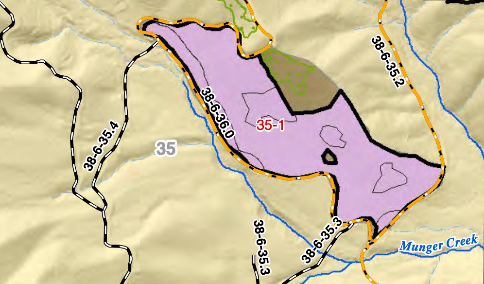
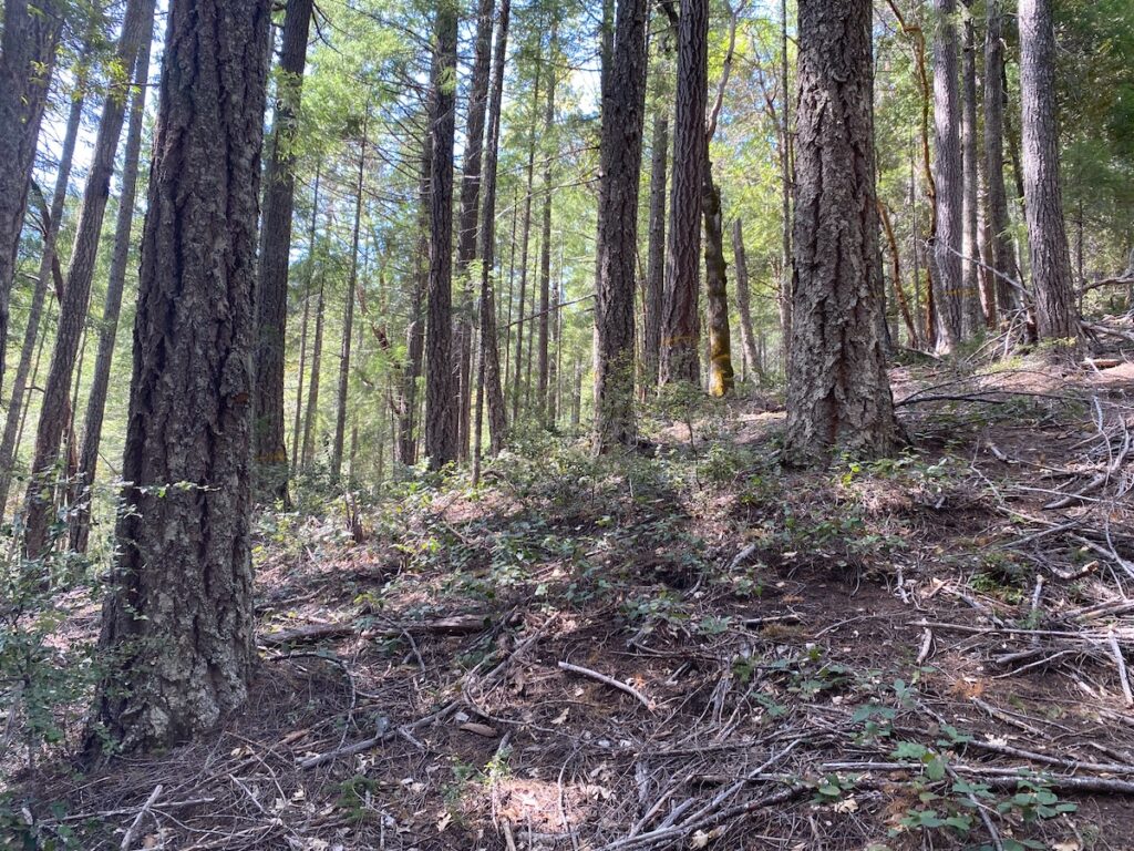
Unit 35-1
Unit 35-1 is a moist and highly productive forest habitat with significant populations of coastal forest species such as salal, pacific yew, red huckleberry, scattered tanoak and Port Orford-cedar.
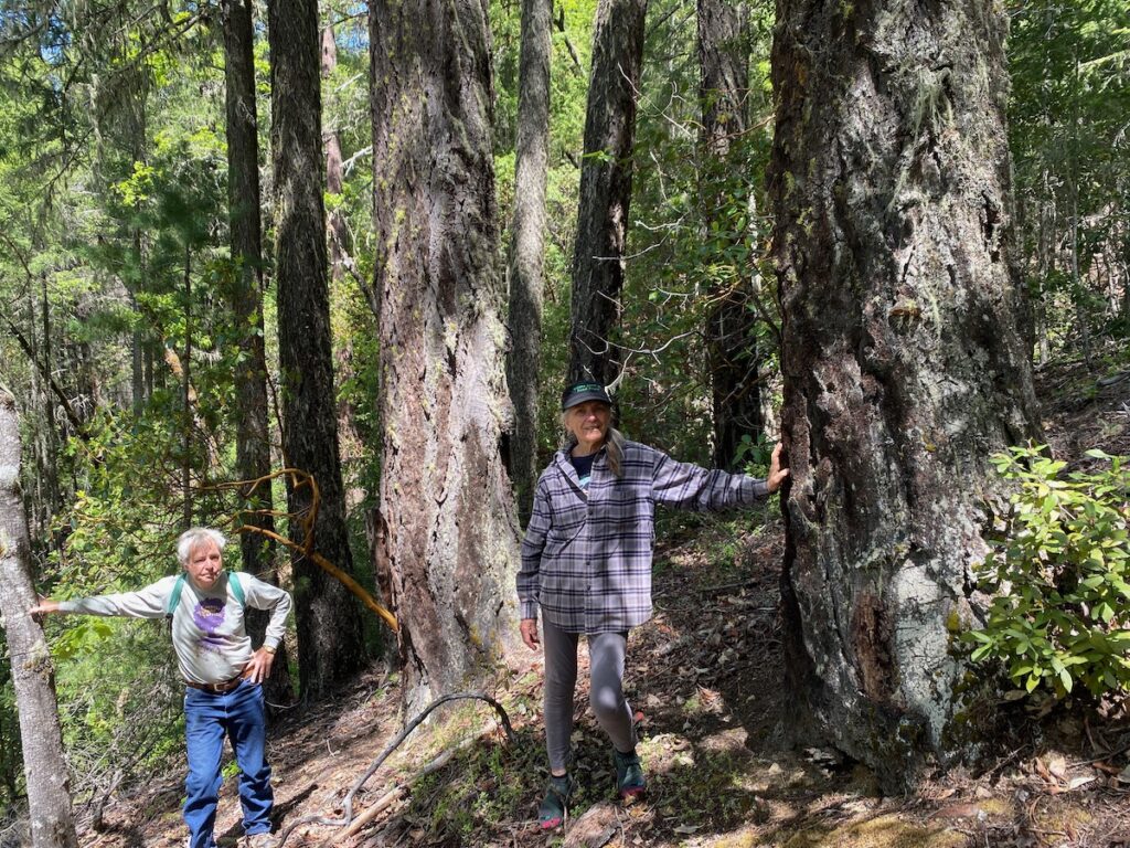
The stand was historically high graded in previous BLM logging treatments, removing the largest overstory trees in what was likely a very dense, closed canopy stand of Douglas fir and Port Orford cedar. Today, after the historic logging impacts, the lower portion of the stand, closer to Munger Creek, supports patchy groves of mature Port Orford cedar and Douglas fir between 18” and 40” diameter, while higher on the slope patches of Douglas fir and sugar pine grow among remnant old-growth hardwoods and patches of madrone.
The gnarled old-growth hardwoods include some of the most impressive golden chinquapin in the Applegate watershed and are remnants of the previous old-growth forest that survived in this location for hundreds of years before BLM logging operations. These old chinquapin trees over 40” in diameter, contain twisted old canopies, internal cavity habitat, complex branch structure and important old forest characteristics.
A dominant, 33″ Douglas fir targeted for removal in unit 35-1 of the Penn Butte Timber Sale.
Although the agency claims the prescription for this unit emphasizes fuel reduction, it targets many large, fire resistant overstory trees and proposes the creation of group selection openings in moist, coastal influenced forests. These forests are more likely to act as fire refugia, than to burn at high severity. Growing low on the slope near Mungers Creek and a small tributary stream, the area is lush, moist, and highly productive, with forest associations more adapted to high rainfall and fog than frequent fire. The specific location of this unit, is perhaps one of the least likely areas to burn at high severity on this landscape and the most likely to develop high quality northern spotted owl habitat conditions if left undisturbed.
Located in high relative habitat suitability for the northern spotted owl, logging these stands will degrade northern spotted owl habitat, reduce forest complexity, degrade canopy conditions and reduce available denning habitat for the Pacific fisher, while also increasing fire risks and impacting scenic values.
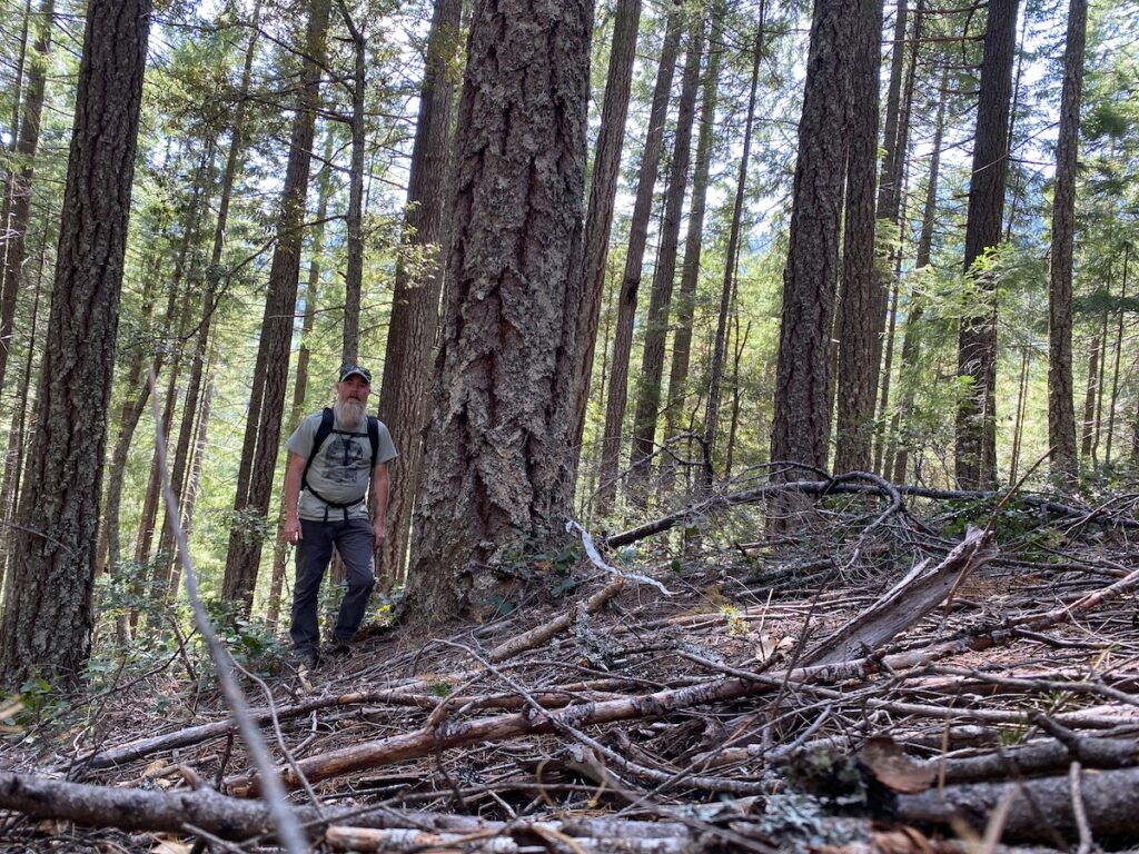
Unit 35-1 is a moist, productive, and relatively open forest dominated by large trees. This photograph shows large trees over 30″ diameter targeted for removal.
Our monitoring efforts identified many Douglas fir trees between 30” and 33” in diameter identified for removal in unit 35-1. The removal of these large overstory trees along with the surrounding cohorts, will dramatically open canopy cover in moist, temperate forests that naturally support dense, closed canopy forest types. Unit 35-1 is not a dry, frequent fire forest and does not require logging treatments to maintain its health (no forest does). In fact, if anything it is still recovering from previous BLM logging treatments and must be allowed to mature to both reach its full stand development capacity and to maintain northern spotted owl habitat conditions in the Mungers LSR.
Conclusion:
Although stand conditions vary throughout the large footprint of commercial logging units proposed on Mungers and Powell Creek in the Penn Butte Timber Sale, we have found numerous common threads throughout the timber sale area. These commonalities pertain to the inappropriateness of logging treatments proposed in the Mungers LSR, the proposed removal of large, fire resistant trees, the dramatic reduction of canopy cover, the loss of forest complexity, and the degradation of northern spotted owl habitat. It also pertains to the consistent increase in fire risks that would occur if the industrial logging prescriptions in the Penn Butte Timber Sale were implemented.
Rather than restore or protect forests and communities from wildfire, the Penn Butte Timber Sale will threaten forests and communities with increased fire risks. According to the BLM’s own research the type of logging proposed tends to create brush and slash fuel types that are, “more volatile and susceptible to high rates of fire caused mortality. Stands could exhibit higher flame lengths, rates of spread, and fire intensity. Fires started within these stands could be difficult to initially attack and control,” and “the overall fire hazard would increase in these stands.”
Large trees in a beautiful old forest grouping proposed for logging on the slopes above Mungers Creek in unit 31-1B. These trees are all over 30″ in diameter and are some of the largest, most dominant trees in this stand. The entire grouping is proposed from group selection logging and would be removed if the Penn Butte Timber Sale moves forward.
Under the current climate scenario, we cannot afford to damage these old forests any further. They are vitally important for carbon storage, for climate mitigation, for connectivity, biodiversity, and watershed health. The Penn Butte Timber Sale, the Late Mungers Timber Sale and IVM Project should be withdrawn, LSR forests should be expanded as carbon reserves on federal lands, and the last old forests remaining on BLM lands should become part of the solution, rather than being managed to perpetuate the problem. Stop the IVM and Late Mungers Project!
The Penn Butte Timber Sale is “leave tree” or “retention” marked, meaning only trees marked with yellow or red paint will be retained after logging operations take place. The large, Douglas fir trees over 30″ diameter unmarked with yellow paint are proposed for removal in unit 25-1A at the headwaters of Powell Creek.
The Medford District BLM recently approved the Integrated Vegetation Management for Resilient Lands (IVM) Project, which allows the agency to implement up to 20,000 acres of commercial logging and 90 miles of new road construction per decade without additional site-specific scientific analysis or meaningful public involvement opportunities. To make matters worse, this proposal focuses its commercial logging activities in areas outside the BLM’s “timber harvest land base” including Late Successional Reserve (LSR) forests designated to protect old forest habitat for the threatened northern spotted owl.
When authorizing the IVM Project, the BLM approved a theoretical “program of work” and has begun implementation of this project in the Applegate Valley by proposing the Late Mungers Vegetation Management Project, including both the Penn Butte and Late Mungers Timber Sales. Located in the mountains between Williams and Murphy, Oregon the agency has designed these timber sales and marked trees for removal without any public input or transparency, and has released a Draft Determination of NEPA Adequacy, tentatively approving the project before engaging the public.
These timber sales target some of the last intact forests in the Mungers Late Successional Reserve, an area intended to protect the connectivity of old forest habitat between the Applegate and Illinois River watersheds. Large, old trees up to 40” diameter have been authorized for removal in the Late Mungers and Penn Butte Timber Sale and significant canopy removal is also proposed. These activities will increase fire risks, damage our climate, degrade important old forest habitat, and impact scenic values in this unique and beautiful region.
A large 34″ Douglas fir tree proposed for logging in unit 18-1E of the Penn Butte Timber Sale. This unit is located on Powell Creek.
Additionally, the forests proposed for logging are important to the surrounding communities and for outdoor recreation. In fact, large portions of the area were designated as the Mungers Butte Recreation Management Area in the 2016 RMP due to the area’s beautiful forests, scenic vistas and its proximity to nearby communities.
Unfortunately, none of these site-specific impacts have been adequately analyzed in the IVM Programmatic EA or the Draft Determination of NEPA Adequacy, and the public involvement process for the Late Mungers Project is severely lacking. We ask the Medford District BLM and Department of Interior to withdraw the IVM Programmatic EA and the Late Mungers Vegetation Management Project, neither project serves the public interest and neither will lead to positive, restorative outcomes.
A grouping of old, open grown trees targeted by the BLM for removal in unit 30-2 in the North Fork Mungers Creek watershed. The large Douglas fir tree in the foreground is 35″ diameter and would be logged if the Penn Butte Timber Sale is implemented.
Please comment on the Late Mungers Project. We only have until June 28 to make our voice heard. Below are talking points intended to help identify key issues to address during the comment period. Please comment now! Additional links and information on providing public comment are included at the end of this post.
Late Mungers & Penn Butte Timber Sale Talking Points:
The scope, scale and intensity of logging, road building and vegetation management activities proposed in the Late Mungers Vegetation Management Project will have significant environmental impacts. The analysis and disclosure of these impacts should require a full Environmental Assessment (EA) or Environmental Impact Statement (EIS).
The BLM is inappropriately using a Determination of NEPA Adequacy (DNA) Worksheet to implement the Late Mungers Project. DNAs can only be utilized if site-specific analysis has already been conducted and documented in a prior NEPA document such as an EA or EIS. Because the IVM Programmatic EA did not analyze and disclose site-specific impacts for the Late Mungers Project, a DNA worksheet is not sufficient for complying with NEPA requirements. The Late Mungers Project requires the BLM to conduct a site-specific EA.
The Late Mungers Vegetation Management Project was not frontloaded with appropriate levels of public involvement before project objectives, treatment areas, and prescriptions were identified.
The range of alternatives considered in the Late Mungers Vegetation Management Project was inadequate and was not informed by public scoping comments as required under the National Environmental Policy Act (NEPA).
Contrary to the rhetoric of the BLM, the Late Mungers & Penn Butte Timber Sales will not create restorative outcomes or increase forest resilience. Instead, the projects propose old forest logging, significant canopy reduction, the removal and downgrading or suitable northern spotted owl habitat, and the removal of large diameter trees up to 40” in diameter. These activities will degrade forest habitats, increase fire risks, reduce resilience, impact nearby communities, and impact recreational opportunities.
Neither the Draft Determination of NEPA Adequacy (DNA) nor the IVM Programmatic EA adequately considered the projects site-specific impacts or environmental conditions.
Neither the Draft Determination of NEPA Adequacy nor the IVM Programmatic EA appropriately analyzed or disclosed the site-specific impacts of project activity on the climate, watersheds, communities, and wildlife of the Late Mungers Planning Area.
Neither the Draft Determination of NEPA Adequacy nor the IVM Programmatic EA adequately analyzed or disclosed the site-specific impacts of proposed project activity on the Mungers Late Successional Reserve (LSR) or considered the consistency of this specific project with the old forest, carbon and connectivity values of the Mungers LSR.
Neither the Draft Determination of NEPA Adequacy nor the IVM Programmatic EA adequately analyzed or disclosed the site-specific impact of project activities on the northern spotted owl or its habitat.
Neither the Draft Determination of NEPA or the IVM Programmatic EA analyzed or disclosed the site-specific impacts of proposed project activity on the surrounding communities or the Mungers Butte Extensive Recreation Management Area.
Implementation of the Late Mungers and Penn Butte Timber Sale will threaten the communities of Williams and Murphy in the Applegate Valley with increased fire risks associated with large tree removal, canopy reduction, and significant microclimate alterations from commercial logging “treatments” proposed in the Late Mungers Vegetation Management Project.
Please withdraw the IVM Programmatic EA and the Late Mungers Determination of NEPA Adequacy document. Neither serve the public interest or encourage appropriate levels of public involvement on public lands.
All but the tree at the center of this photo would be removed in unit 31-1E of the Penn Butte Timber Sale. Trees up to 33″ diameter are marked for removal in this unit located above Williams on Mule Gulch.
For more information on the Penn Butte Timber Sale including maps of the proposed units follow this link.
To provide public comment on the Penn Butte Timber Sale click here.
Units we have reviewed in the Penn Butte Timber Sale are “leave tree marked,” meaning only trees marked with yellow paint would be retained if the timber sale was implemented. Under a leave tree mark this 34″ diameter, unmarked ponderosa pine would be logged in unit 31-2 , below the Jones Marble Quarry and above the community of Williams in the Applegate Valley.
The Medford District BLM recently approved the Integrated Vegetation Management for Resilient Lands (IVM) Project, a large, landscape-scale industrial logging project dressed up in the language of so-called “forest restoration,” and designed to undermine the public involvement process.
The IVM Project would authorize the BLM to log up to 20,000 acres and build up to 90 miles of new road per decade without site specific environmental or scientific review, no public disclosure of impacts and dramatically reduced public involvement processes. To make matters worse, the project is designed specifically to log Late Successional Reserve (LSR) forests set aside to protect habitat for the imperlied northern spotted owl and other areas currently outside the agency’s “timber harvest land base.”
The BLM intends to begin implementation of the IVM Project this coming fall with the Penn Butte and Late Mungers Timber Sales, west of Williams, Oregon. The proposed Penn Butte Timber Sale is located in the old forests of the Mungers Late Successional Reserve, and the BLM is currently designing the project with absolutely no public transparency or accountability. In fact, despite the repeated requests of residents from Williams and the Applegate Valley, the BLM has refused to provide maps or information on the timber sale, while at the same time marking trees and timber sale unit boundaries adjacent to our homes and communities.
Watch this 10 minute video about our recent field review of Penn Butte Timber Sale units on Marble Gulch and North Fork Mungers Creek above Williams, Oregon.
In an attempt to shed some light on the BLM’s secretive timber sale plans, ANN has been scouring the landscape for marked timber sale units above Williams. On a recent weekend we were out monitoring the timber sale mark in the Penn Butte Timber Sale on Mungers Butte, as well as in the Mungers Creek and Marble Gulch watersheds, both of which are tributaries of West Fork Williams Creek.
Despite the rhetoric of forest restoration and resilience, and the claims of benevolence in the Environmental Assessment (EA) for the IVM Project, the real intent of the project becomes very clear as the tree removal mark is reviewed in the field. Although the BLM claims that the IVM Project and the Penn Butte Timber Sale will be beneficial to the forests of southwestern Oregon, the tree removal mark demonstrates otherwise, and the project is, in fact, a derisive and shameful attempt by the BLM to circumvent important public involvement processes, manipulate science, mislead the public and log some of the last mature forests in our region under the guise of “restoration” and “resilience.”
The Impacts of the IVM Project & the Proposed Penn Butte Timber Sale
Old forests like those in unit 31-1 of the Penn Butte Timber Sale are proposed for logging under the provisions of the IVM Project. Many large, old trees like the large Douglas fir in the foreground of this photo, would be logging if the Penn Butte Timber Sale moves forward, dramatically impacting habitat values, increasing fire risks, and degrading public forests.
The Penn Butte Timber Sale was designed by the BLM to target relatively intact, mature and old forest stands with industrial logging prescriptions. Although the agency claims otherwise, the project will produce timber for the industry at the expense of public values, environmental concerns, and recreational values.
Under the provisions of the IVM Project, the BLM has identified trees up to 36″ in diameter and over 150 years old for removal . They are also proposing to reduce canopy cover down to as low as 30%-40%, removing extensive suitable northern spotted owl habitat designated for protection in the Mungers Late Successional Reserve. They also intend to implement damaging group selection logging prescriptions. These activities will downgrade or remove thousands of acres of northern spotted owl habitat, pushing the species further towards extinction.
According to the Decision Notice for the IVM Project, group selection cuts with either no tree or minimal tree retention can occur in up to 20% of a timber sale area, and would consist of a staggered patchwork of 2 acre clearcuts embedded within mature forest stands also subjected to heavy commercial thinning. BLM staff have describe this as the “swiss cheese” treatment, where whole groves of mature forests are logged off, creating gaping holes in the forest canopy.
This group selection cut proposed in unit 31-1 would remove every old tree in this photograph.
Yet, even BLM’s own analysis of the effects of group selection logging admits that dramatically reducing forest canopy and embedding young regeneration within mature forest stands will increase fire risks. According to the BLM, group selection logging will create brush and slash fuel types that are “more volatile and susceptible to high rates of fire caused mortality. Stands could exhibit higher flame lengths, rates of spread, and fire intensity. Fires started within these stands could be difficult to initially attack and control,” and “the overall fire hazard would increase in these stands.”
These same mature forests proposed for logging in both the IVM Project and the Penn Butte Timber Sale store abundant carbon in the trees, snags, downed wood and forest soils. When logged these forests are quickly converted from carbon sinks to significant emission sources, releasing large volumes of stored carbon as they are converted from living trees, logged, and then made into wood products.
Mature forests store moisture, hold humidity on the landscape, and maintain cool, moist habitats in a warming climate. These habitats, in turn, provide climate refugia for plant and wildlife species requiring persistent forest habitat. Opening these stands with commercial logging, removing large trees and reducing forest canopy significantly alters microclimate conditions, increases temperatures and wind speeds, dries forest soils, increases drought stress, and encourages climate induced mortality.
Unit 31-2 currently supports diverse, open structured forests with old conifers and hardwood species. In the Penn Butte Timber Sale, literally every tree in this photograph was “unmarked” and identified for logging, except the large ponderosa pine tree at the center of the photo and another large Douglas fir in the distant right hand corner that are marked with yellow. This beautiful forests would be logged down to a few scattered trees under the BLM’s so-called Integrated Vegetation Management for Resilient Lands prescriptions.
After a weekend hiking the units of the Penn Butte Timber Sale, we can definitively say that implementation of the IVM Project and the Penn Butte Timber Sale would make these forests more inhospitable to species like the northern spotted owl and would undermine the purpose of LSR forest designations. The proposed logging would also release large amounts of carbon currently stored in mature trees, contributing to a more extreme, dangerous, and unpredictable climate. Finally, implementation of the IVM Project would dramatically increase fire risks for the neighboring communities, making wildfires more fast moving and severe.
The Penn Butte Timber Sale is a direct outcome of the BLM’s approval of the massive IVM Project and it is just the first timber sale proposed for implementation, but is a sign of what the BLM intends to do across the 800,000-acre IVM Planning Area. While the BLM’s rhetoric surrounding the IVM Project is meant to mislead and confuse the public, the combined impact of IVM implementation, in the Penn Butte Timber Sale and many other timber sales to come, is dramatic and clear. If implemented, local communities would be negatively impacted, forests would be degraded, carbon would be released, wildlife would suffer, recreational opportunities would be diminished or destroyed and the public’s ability to participate in local public land management planning would be dramatically curtailed.
For the climate, for the wildlife, for our watersheds, and for the people of our region and the world, the mature forests of southwestern Oregon are best left standing. The BLM must cancel the IVM Project and the Penn Butte Timber Sale, become part of the solution, safeguard our climate and protect our diverse, fire resistant, and carbon rich forest habitats!
Below is a description of units ANN has recently monitored in the Penn Butte Timber Sale above Williams, Oregon, as well as directions on how to get there, so you can access these units yourself to see the old trees BLM intends to log.
Marble Gulch & North Fork Mungers Creek Units
Unit 31-1
The large, old trees in this photograph have been identified as a group selection logging area in unit 31-1 of the Penn Butte Timber Sale and are proposed for removal. This includes trees up to an estimated 180 year or older and up to 36″ diameter.
Unit 31-1 is a large timber sale unit sprawling across a wide variety of habitats. In general, the stand consists of mature and late successional mixed conifer forest of Douglas fir, incense cedar, ponderosa pine, sugar pine, live oak, tan oak and madrone. Portions of the unit are located on Mule Gulch, a tributary of Marble Gulch, while other portions of the unit are located just over the ridge in the North Fork Mungers Creek watershed.
Most of the stand maintains a closed canopy, and scattered clumps or groupings of dominant overstory trees are found across the unit. Beneath these dominant, old-growth trees, grows a younger cohort, creating a secondary or layered canopy which shades the forest floor, suppresses understory growth and reduces the development of dense understory fuel beds, while also supporting important northern spotted owl habitat.
The unit is leave tree marked, meaning only the trees marked with yellow paint would be retained, and any tree left unmarked in this stand would be targeted for removal in the Penn Butte Timber Sale. The unit includes areas proposed for heavy commercial thinning, while other portions would be subjected to group selection logging, a form of staggered clearcut forestry.
Standing next to a 33″ diameter Douglas fir tree “unmarked” for removal in the Penn Butte Timber Sale.
In unit 31-1 we measured Douglas fir trees up to 35″ in diameter and likely over 180 years old proposed for removal. We also found group selection cuts marked that propose the removal of whole groves of mature trees between 24″ and 35″ in diameter. Contrary to the claims in the IVM Project EA, the Penn Butte Timber Sale would heavily fragment and degrade the Mungers LSR, increase fire risks, and reduce forest complexity.
Unit 31-1 can be accessed by walking up the gated Marble Gulch Road (39-5-5) and heading left at the first intersection on road 39-5-31.4. Look for bright flagging, unit boundary signs and yellow painted trees. The unit is flagged on the boundary. Head up into the forest and zigzag back and forth through the unit to see the old trees BLM intends to log.
Unit 31-2
An over 30″ diameter Douglas fir left unmarked for removal in Unit 31-2 on Marble Gulch above Williams, Oregon.
Unit 31-2 is located on Marble Gulch Road (BLM Road 39-5-5 and 39-5-31.3) below the Jones Marble Quarry. Long a landmark and hiking destination in the Williams area, residents frequently hike the closed road to the mine through the mature and late successional forests below. These beautiful old forests are the attraction for this hike and are well loved by local residents in the Applegate and Williams Valleys. Unfortunately, the BLM is targeting these spectacular forests for logging in the Penn Butte Timber Sale.
Much of unit 31-2 is located on south facing slopes, but maintains mature forest cover, consisting of Douglas fir, incense cedar, ponderosa pine and sugar pine. The stand also supports beautiful hardwoods, including madrone, live oak and tanoak trees. Relatively open spaced, the groves proposed for logging include many large, old trees and diverse forest habitats.
The unit has a leave tree or retention tree mark, meaning only those trees identified with yellow paint will be retained if logging occurs. During our visit we measured ponderosa pine trees up to 34″in diameter, Douglas fir trees up to 33″ in diameter and incense cedar over 24″ in diameter identified for removal.
Another over 30″ diameter Douglas fir left unmarked and targeted for logging in unit 31-2. Only a handful of trees identified with yellow paint would be retained if the Penn Butte Timber Sale is implemented.
Both unit 31-2 and most of unit 31-1 have been previously thinned in the Deer Willy Stewardship Project, which was touted as a “restoration” and fuel reduction project, but is now clearly being used as a “pre-commercial thin,” in which non-merchantable and marginally merchantable material was removed in preparation for the BLM’s timber-heavy Penn Butte Timber Sale. The 2010 Deer Willy Stewardship Project thinned the small trees, and now the BLM is going after the old trees in the same area.
Rather than working to restore forest habitats or minimize fire risks, the BLM is instead implementing the Penn Butte Timber Sale to produce logs for the timber industry at the expense of wildlife habitat, the health of our forests, and in a manner that maximizes rather than minimizes fire risks.
Unit 31-2 can be accessed by walking up the gated Marble Gulch Road (39-5-5) and heading right at the first intersection on road 39-5-31.3. Look for bright flagging, unit boundary signs and yellow painted trees to identify the proposed timber sale unit. A walk up road 39-5-31.3 to the Jones Marble Quarry offers hikers the ability to enjoy a relatively easy old forest hike near Williams, Oregon and the opportunity to view firsthand the logging proposed by BLM in the beautiful forests of Marble Gulch.
Unit 25-1
Large Douglas fir trees proposed for removal in a group selection cut in unit 25-1.
Unit 25-1 is located on a southeastern face high in the North Fork Mungers Creek watershed, just off Upper Powell Creek Road (BLM Road 38-5-15) and near the wide intersection with the gated BLM road 38-6-25.
The stand proposed for logging in unit 25-1 consists of largely closed canopy Douglas fir, ponderosa pine, sugar pine and madrone, with a significant mature, mid-successional forest component and scattered groupings of large, old trees.
As you can imagine, removing whole groves of large fire resistant trees is detrimental to the northern spotted owl and other species dependent on late successional forest habitat such as the Pacific fisher. In LSR forest designated specifically for the protection of late successional forest habitat, the large tree removal, group selection logging, and dramatic canopy reduction proposed in the IVM Project and the Penn Butte Timber Sale is both highly problematic and inconsistent with the goals and objectives of LSR designation.
Like other units we visited, unit 25-1 was previously thinned in the Deer Willy Stewardship Project, which focused on small diameter tree removal and largely non-merchantable, non-commercial fuel reduction treatments. According to the analysis for the Deer Willy Project, which was ultimately implemented by the Lomakatsi Restoration Project, the treatments were intended to restore habitat conditions and reduce fuel loading. To some extent these initial stewardship treatments may have met some of these objectives, yet the BLM is now proposing large tree removal, heavy industrial logging and significant canopy reduction in these same locations, using former “restoration” treatments as a “pre-commercial” thins in preparation for the Penn Butte Timber Sale and the removal of large, old, fire resistant trees.
Heavy commercial logging is counterproductive and inconsistent with the goals and objectives of the formerly implemented Deer Willy Stewardship Project. By logging large, old trees previously targeted for retention and “release,” previous stewardship efforts are being undermined and reversed.
A large Douglas fir proposed for removal in unit 25-1 of the Penn Butte Timber Sale.
Like the other units we have reviewed in the Penn Butte Timber Sale, unit 25-1 is leave tree or retention marked, meaning only trees marked with yellow paint would be retained if logging operations take place. If such logging was to occur in unit 25-1, many large, old trees would be removed and significant canopy fragmentation would occur, creating a loss of natural fire resistance and northern spotted owl habitat.
To access unit 25-1 drive Upper Powell Creek Road (Road 38-5-15) along beautiful Powell Creek, then switch back to the ridge. At the ridgeline, you will see a wide pullout at the intersection of gated roads 38-6-25 and 38-6-25.5. The area between Upper Powell Creek Road and road 38-6-25 is proposed for logging in the Penn Butte Timber Sale as unit 25-1.
Powell Creek Units
Unit 26-1
Only three trees marked with red paint would be retained in this portion of unit 26-1. All other trees in this stand would be removed if the Penn Butte Timber Sale is implemented.
Unit 26-1 is located on an east-facing slope at over 4,000′ on the flank of Mungers Butte near the headwaters of Powell Creek. Being higher in elevation than other timber sale units we have recently surveyed, unit 26-1 contains a more montane forest habitat dominated by Douglas fir and grand or white fir, along with an understory of chinquapin and Cascade Oregon grape.
Like other units, the stand is leave tree or retention marked, but unlike other units, crews utilized red paint to identify trees for retention. Again, these stands were lightly thinned in the Deer Willy Stewardship Project, which removed largely small diameter trees, along with some young hardwood trees and shrub species. These previous management efforts maintained canopy conditions and did not trigger an extensive understory shrub response and fuel increase.
The logging treatments proposed in the Penn Butte Timber Sale would reenter these stands with a more industrial commercial logging prescription, reducing canopy cover, breaking up naturally complex tree groupings, removing much larger, more mature trees, and encouraging the regeneration of dense, young, and highly flammable vegetation where logging occurs.
Located in both the officially designated Mungers Late Successional Reserve and the Mungers Butte Extensive Recreation Management Area, the unit would impact the scenic, recreational, and late successional forest values these areas were designated to protect.
Unit 26-1 is accessible by driving Upper Powell Creek Road (road 38-5-15) past unit 25-1 to the end of the pavement. Shortly after the gravel road begins, you will see bright flagging, unit boundary markers and trees marked with red paint. The unit extends out along the road as it runs up the ridge and then parallel to the slope.
The majority of the large trees in this photograph would be logged if the Penn Butte Timber Sale above Williams, Oregon is implemented
Help us stop the Penn Butte Timber Sale & the IVM Project!
Satellite imagery shows logging increasing in the Williams area over time. This 2-minute timelapse video depicts the impacts to forests from logging from 1985-2020. Even more clearcuts have been logged since 2020.
Winter snow on Elliott Creek in the Upper Applegate River watershed.
After the bigleaf maple leaves fell in the canyons, bright red berries covered madrone trees, and oak woodlands turned the foothills a vibrant golden hue, winter cast its spell across the Applegate Siskiyous. Although relatively mild and dry this season, snow has accumulated in the high country, and at times, blanketed the region from the valley bottom to the highest peaks. Rains have poured from dark clouds obscuring the mountains, filling our rivers and streams with runoff. Winds have howled across the Siskiyou Mountains, blowing down trees and bringing the fire killed snags from the recent Abney, Burnt Peak and Creedence Fires crashing to the forest floor.
The low winter sun has also brightened the grassy balds, dormant oak trees and manzanita thickets, while casting dark, cold shadows across the canyon bottoms and north-facing slopes for months at a time. Each clear, starry night has left sparkling, white frost across the landscape, which accumulates in the shade and melts off each morning in more exposed locations.
With winter waning and spring just around the bend in the Applegate Valley, we ask you to take a moment to appreciate the beauty of winter by viewing this Winter Wild and Scenic Photo Essay, highlighting streams proposed for protection in the River Democracy Act, co-sponsored by Senator Wyden and Senator Merkley.
The Middle Fork Applegate River is one of the premiere streams in the Applegate watershed, with spectacular wilderness tributaries extending into the Red Buttes Wilderness Area and the surrounding wildlands. The Middle Fork and numerous of its wild tributary streams are proposed for Wild and Scenic River protections in the River Democracy Act.
Initiated with an open, public nomination process, the River Democracy Act empowered local citizens to nominate worthy stream segments for Wild and Scenic River protections. In response, ANN got to work documenting and nominating streams across the Applegate River watershed for Wild and Scenic River designation.
From the sparse serpentine canyon of Slate Creek, with fragrant azaleas, charismatic cobra lily fens, and elegant, streamside Port Orford-cedar, to the arid oak woodlands of the Little Applegate River, and to the headwaters of the Applegate River in deep forested canyons below the Siskiyou Crest, the proposed Applegate Wild and Scenic River contains a wide variety of beautiful streams in need of protection.
This post highlights the beauty of the Applegate River and its many wild tributary streams. Please support the River Democracy Act and the designation of Applegate River tributary streams as new Wild and Scenic River segments.
Palmer Creek, a tributary of the Upper Applegate River is a beautiful perennial stream and fishery. Large portions of the watershed support mature, low elevation forests, beautiful oak woodlands and chaparral. Large portions of Palmer Creek are also proposed for protection in the River Democracy Act.
Support Clean Water and Wild Rivers! Here’s how:
Write to Oregon Senators Wyden and Merkley, thanking them for introducing the River Democracy Act. In your letter express your support for the inclusion of Applegate River streams, full, mile-wide stream buffers for all protected streams, and a full mineral withdrawal (allowing no new mining claims) on all protected streams.
2. Submit Letters to the Editor in local newspapers supporting the River Democracy Act and the inclusion of Applegate River streams.
3. Hike a trail, raft a river, and get to know the wildlands in our region. Those who know and love the region are often its best advocates.
4. Encourage your friends, family and neighbors to support the River Democracy Act and fall in love with the Siskiyou Mountains!
Winter Wild and Scenic!
The beautiful blue waters of the Middle Fork Applegate River near its confluence with Cook and Green Creek. Steve Fork Carberry Creek drains the Grayback Range and the northern slopes of the Siskiyou Crest, portions of the Red Buttes Wilderness Area and the Kangaroo Inventoried Roadless Area. Numerous forks of Carberry Creek are proposed for Wild and Scenic designation in the River Democracy Act.
Elliott Creek flows out of the Condrey Mountain Inventoried Roadless Area on the northern slope of the Siskiyou Crest through incredible canyons supporting beautiful old-growth forest, moss-covered bedrock gorges and productive wildlife habitats. Large portions of Elliott Creek are proposed for Wild and Scenic River protections in the River Democracy Act.
The Little Applegate River canyon located on both BLM and Forest Service land was proposed for Wild and Scenic River designation in the River Democracy Act. The stream contains spectacular oak woodlands, dry mixed conifer forests and portions of the citizen identified Dakubetede Roadless Area.Cobra lily fens and Port Orford-cedar line the banks of Cedar Log Creek outside Wilderville, Oregon in the western Applegate River watershed. Cedar Log Creek is proposed for Wild and Scenic River designation in the River Democracy Act and is part of the serpentine wonderlands in the Slate Creek Roadless Area. Flowing out of the Kangaroo Inventoried Roadless Area, the Pipe Fork is the last truly wild tributary of Williams Creek and contains dense old-growth forests of Port Orford-cedar, sugar pine, Douglas fir, ponderosa pine and abundant hardwoods. Federal portions of the stream on BLM and Forest Service land are proposed for designation as Wild and Scenic River in the River Democracy Act. Star Gulch is a beautiful tributary of the Upper Applegate River upstream of Ruch, Oregon. Flowing through the diverse Applegate Foothills, the stream contains a lush riparian area with bigleaf maple, alder and Pacific yew, surrounded by dry mixed conifer forests, oak woodlands, chaparral, arid grasslands, and mixed hardwood forests. Star Gulch is directly adjacent to the BLM’s Burton-Ninemile Lands with Wilderness Characteristics (LWC) and is easily accessible to residents in the Rogue and Applegate Valleys.Whisky Creek is a major tributary of the Middle Fork Applegate River. Flowing down from the high country around Whisky Peak, the watershed contains beautiful, fire adapted old-growth forest accessible by the spectacular Whisky Creek Trail. The mainstem of Whisky Creek is proposed for Wild and Scenic River designation in the River Democracy Act.