The East Applegate Ridge Trail is a beloved and threatened community asset
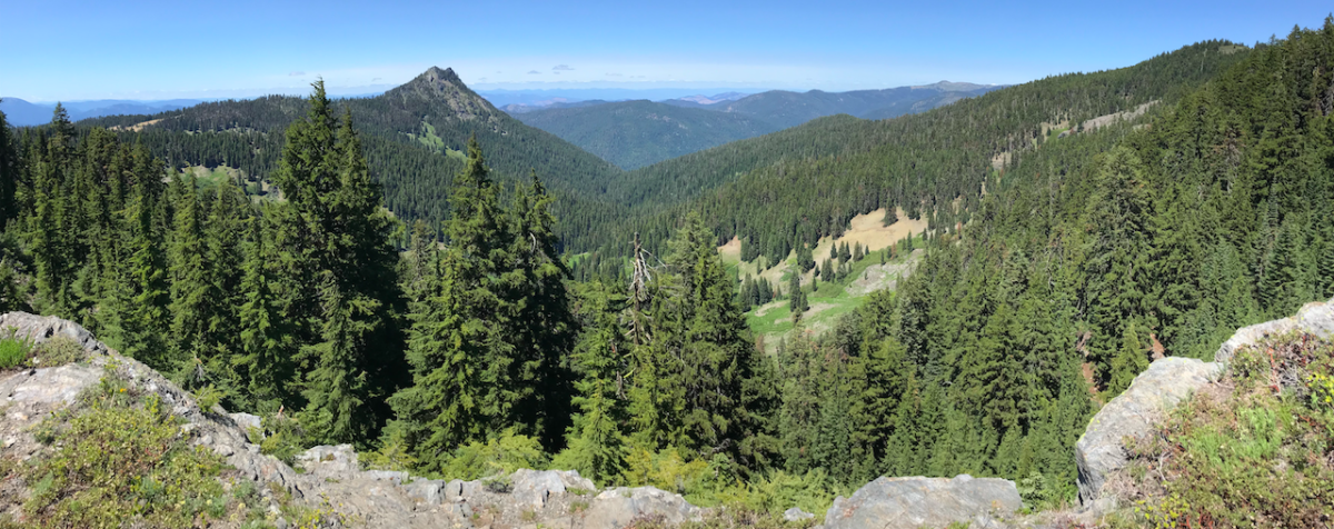
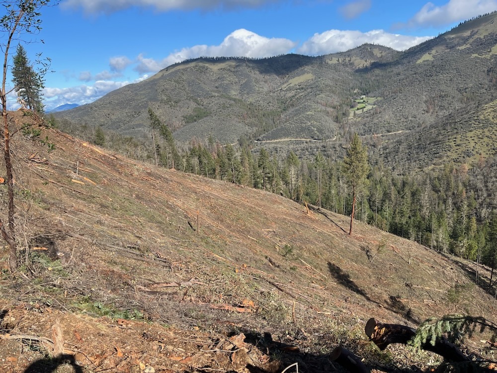
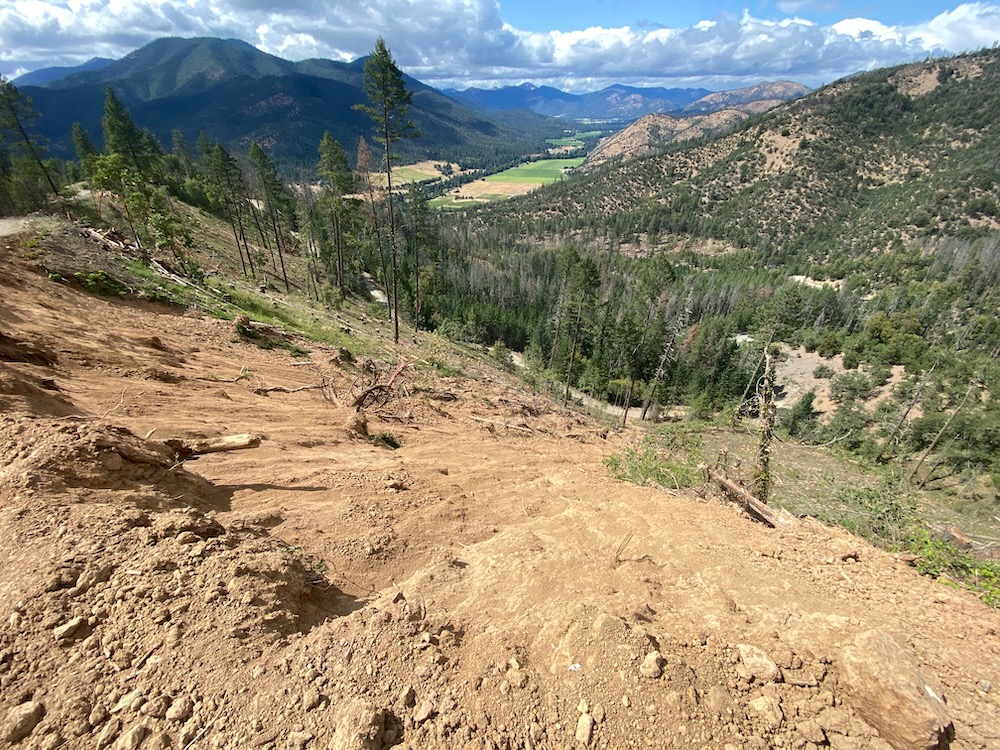
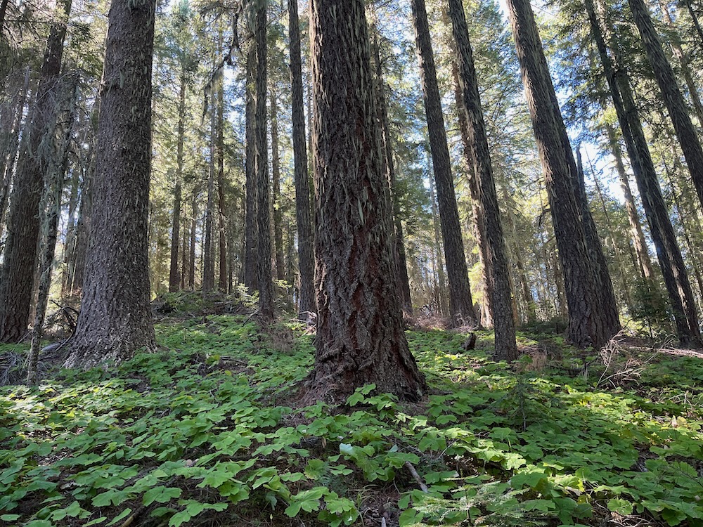
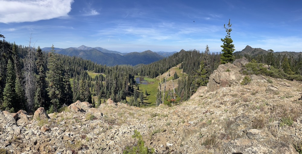
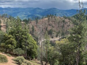
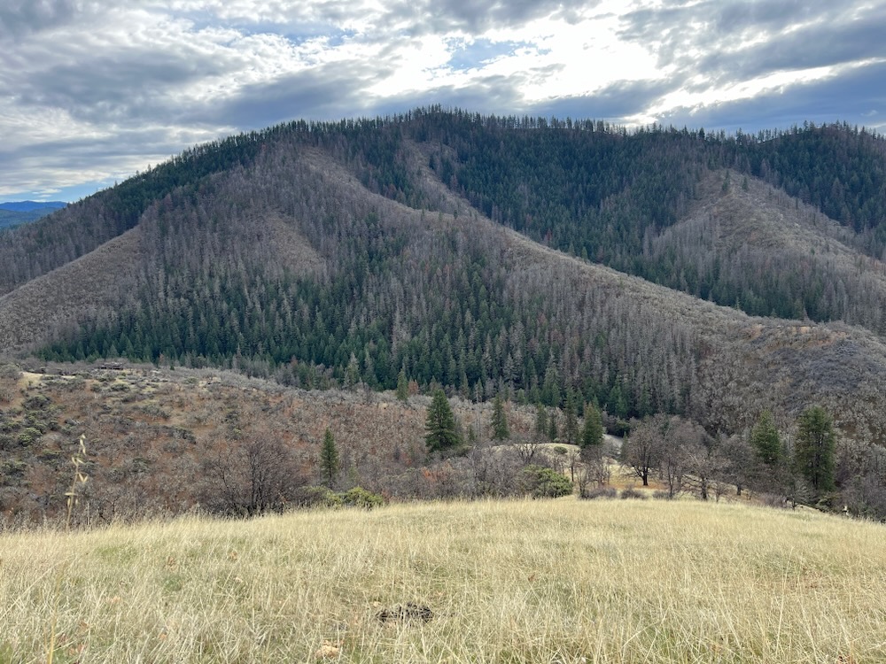
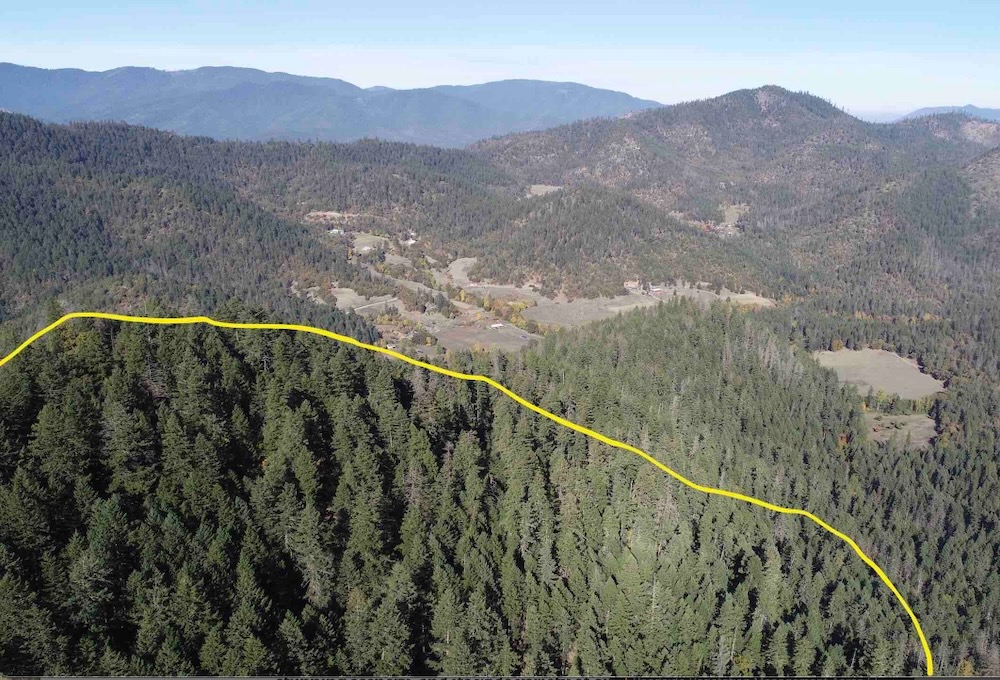
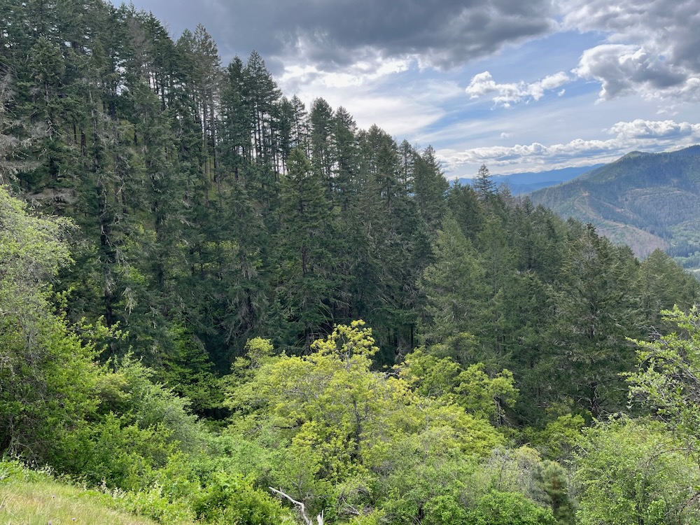
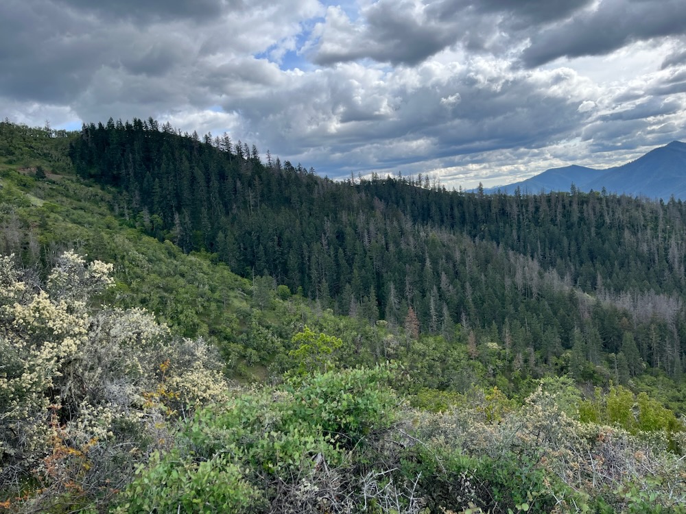
A view from the beloved East Applegate Ridge Trail towards Ruch and Ben Johnson Mountain. The Holcomb Hollow Timber Sale is imminently slated to log portions of this incredible and popular trail system, while Ben Johnson Mountain (in the distance above Ruch) has been devastated by BLM logging operations in the Apple Saws Timber Sale.
For many years residents in southwest Oregon have coalesced around a vision of long-distance, non-motorized trails extending across the Applegate River watershed and connecting communities throughout the Rogue River, Bear Creek and Applegate River Valleys of interior southwest Oregon. These residents have also built multiple organizations dedicated to building these trail systems with the ultimate goal being to link the proposed Applegate Ridge Trail and Jack-Ash Trail systems into the larger, approximately 80-mile Siskiyou Skyline Trail. The trail would extend from Grants Pass to Ashland, Oregon throughout the beautiful Applegate foothills and small portions have already been created.
Yet, since construction of the East Applegate Ridge Trail by the Applegate Trails Association (ATA) and the Jack-Ash Trail by the Siskiyou Upland Trails Association (SUTA) in 2017, residents in the area are just now realizing how vital, transformative, and popular this proposed trail system could be.
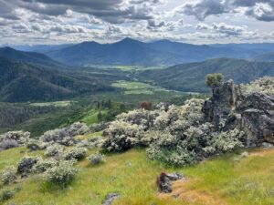
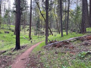
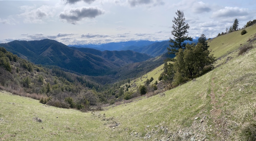
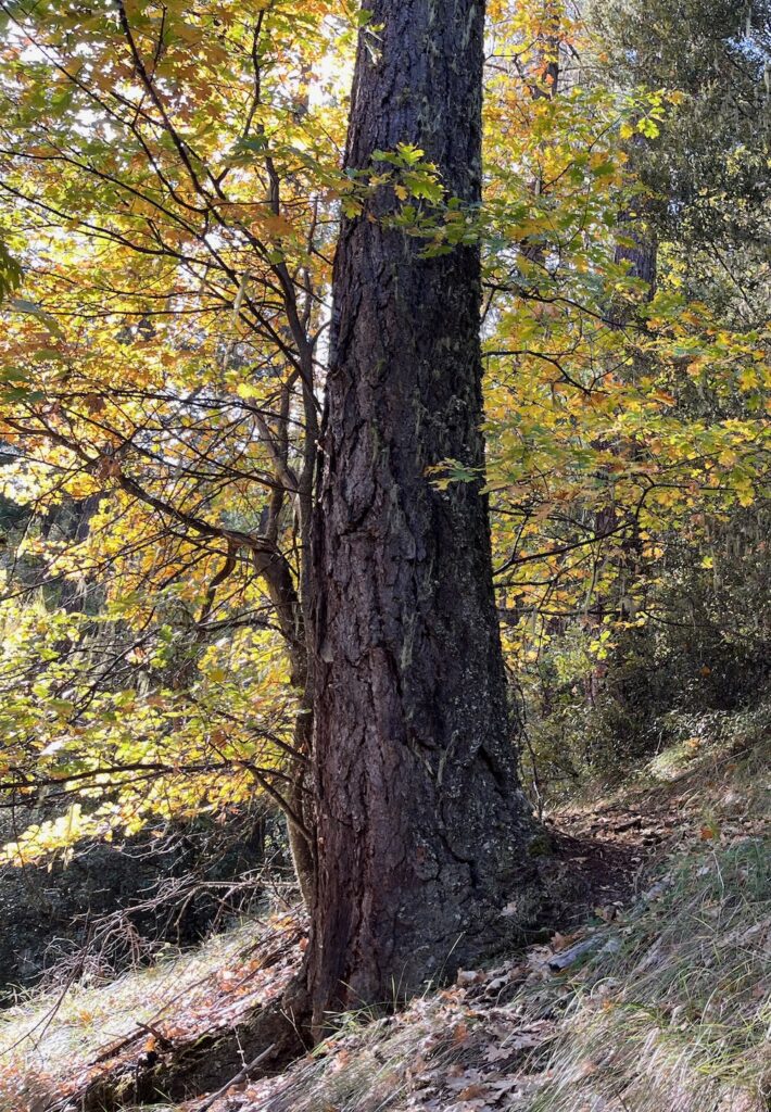
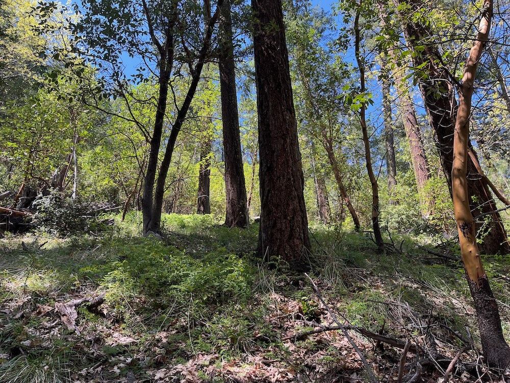
The East Applegate Ridge Trail now attracts thousands of visitors to trailheads in the Applegate Valley each year, and is just a ten-minute drive from Jacksonville at the edge of the Rogue Valley. The trail system is one of the most accessible, scenic, spectacular, and beloved trails in the region. This now iconic Oregon trail contains a beautiful mixture of oak woodland, thickets of chaparral, open grasslands, mixed hardwood forests, mature conifer forests, relatively undisturbed habitats, and colorful wildflower displays.
The area is also cherished for its incredible views across the Applegate Valley, the region’s rugged foothills, and the long, east-west tending spine of the Siskiyou Crest at the headwaters of the Applegate River. It is also popular with hikers, botanists, trail runners, and mountain bikers throughout the region and beyond.
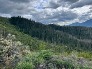
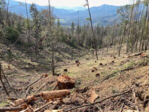
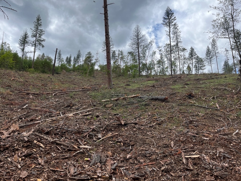
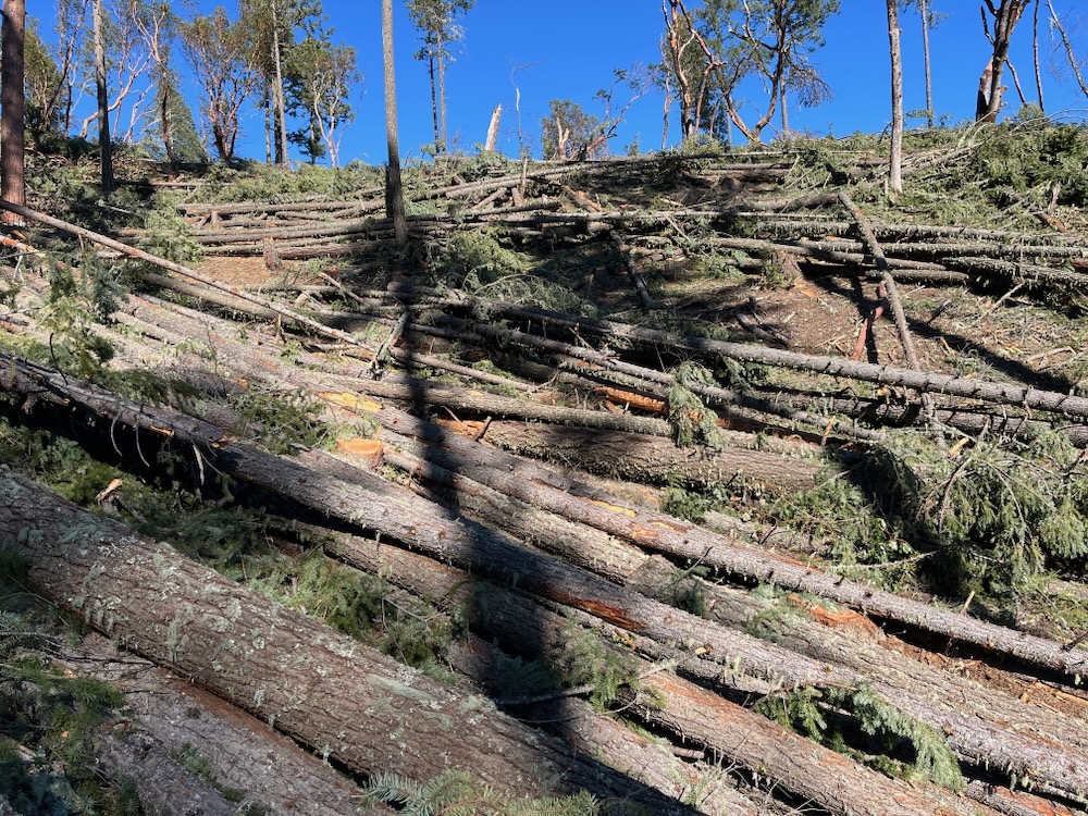
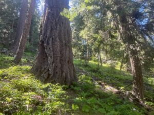
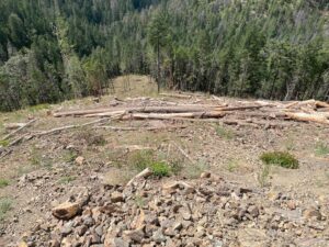
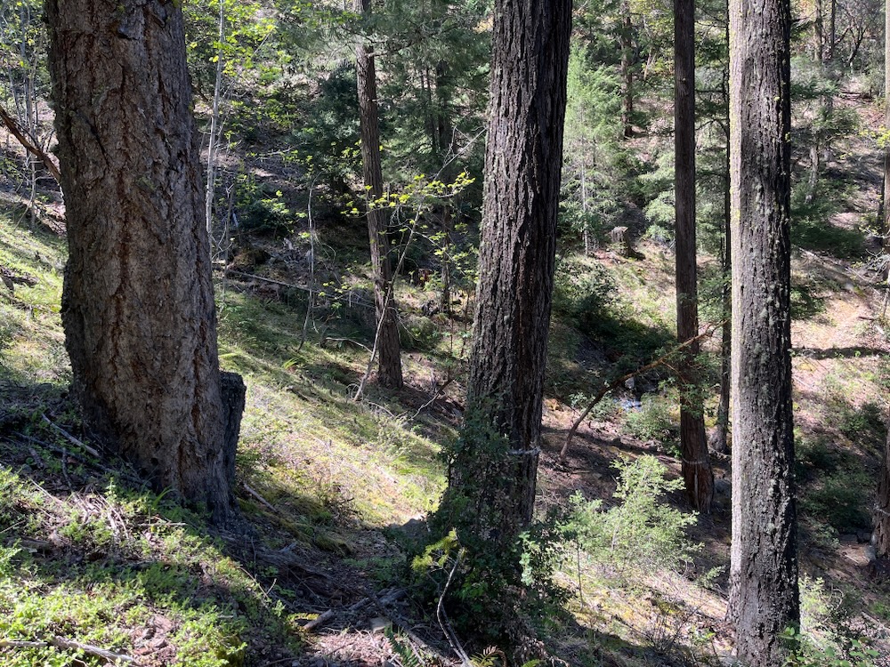
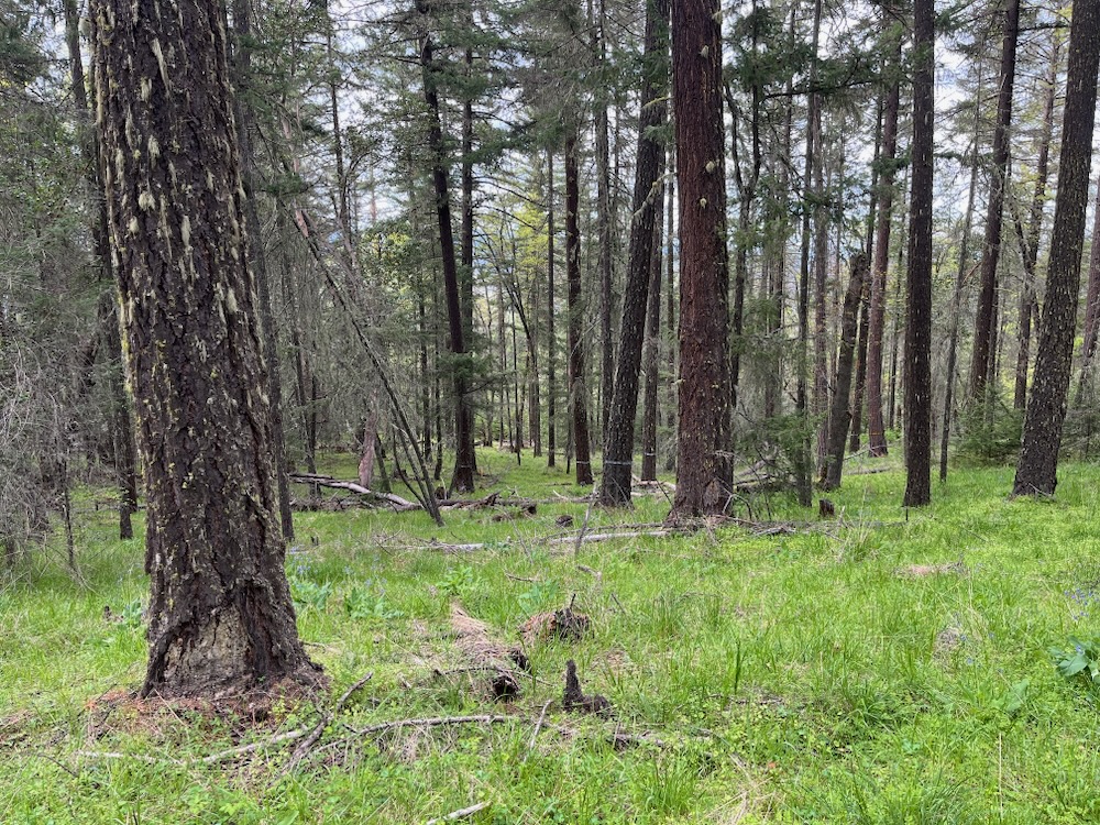
The green forests in this photo are units 13-1 and 14-1 of the Holcomb Hollow Timber Sale and are proposed for heavy industrial logging. They are also within the viewshed of the East Applegate Ridge Trail where this photo was taken. According to the BLM’s Environmental Assessment, the prescriptions in this timber sale call for the removal of nearly all the living trees in these stands, leaving as little as 5% canopy cover, decimating the islands of conifer forests that are surrounded by beautiful oak woodlands.
The East Applegate Ridge Trail provides our region with a sense of pride in both the beauty of this place, and in the local community that has worked so hard to envision, promote, gain BLM approval, build, and maintain this incredible non-motorized trail.
Unfortunately, both the trail’s scenic beauty and the massive community effort that led to the trail’s creation are threatened with BLM logging under the Holcomb Hollow Timber Sale, and this logging could begin any day.
The Holcomb Hollow Timber Sale is damaging to the environment
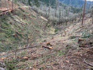
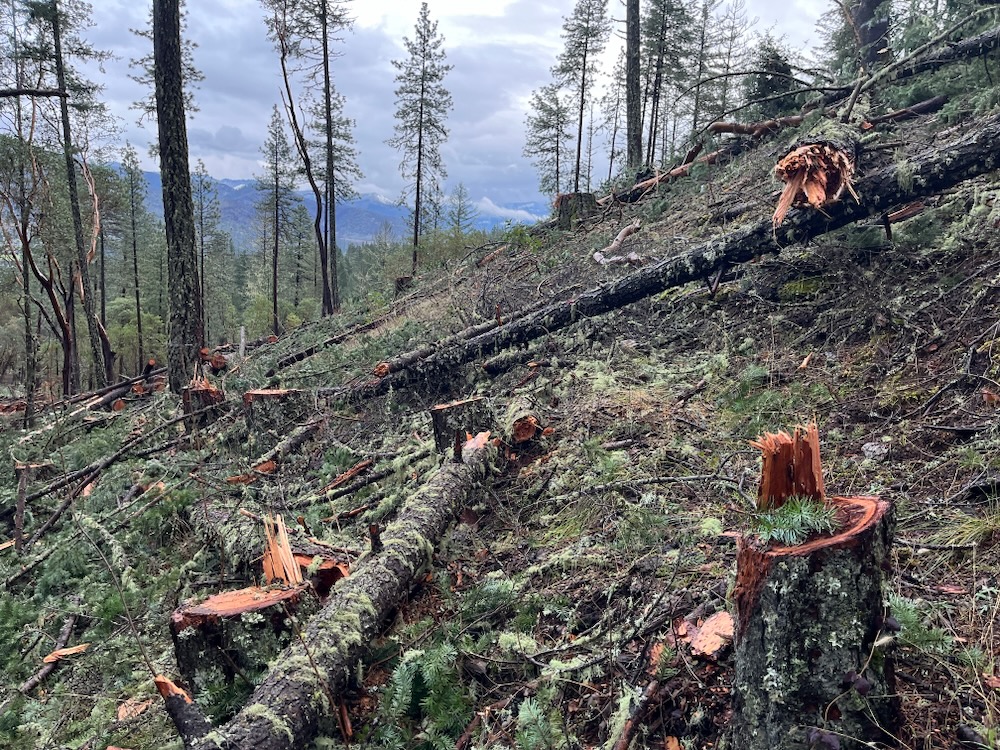
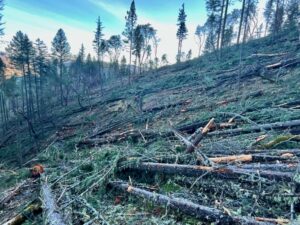
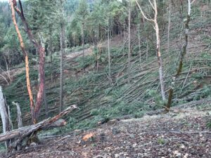
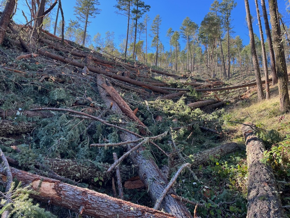
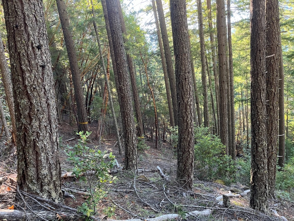
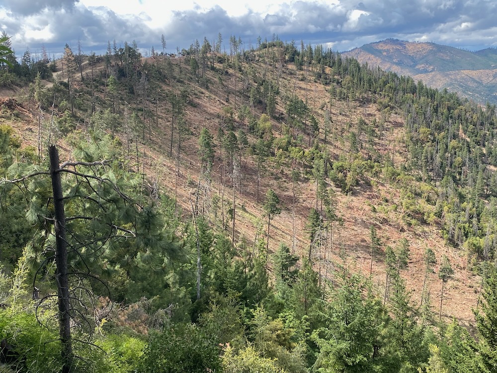
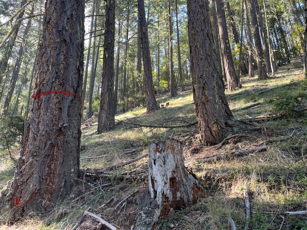
The results of the Holcomb Hollow Timber Sale on the western face of Woodrat Mountain. Many of the units closely resemble clearcuts and every merchantable tree was removed, including living, green conifer trees, living, green hardwood trees, and dead standing snags.
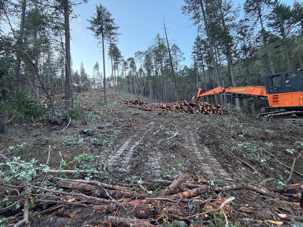
The Holcomb Hollow Timber Sale is a 679-acre timber sale authorized by the BLM under their disastrous Ashland 2025 SOS logging project. Thus far, the Holcomb Hollow Timber Sale has logged the western face of Woodrat Mountain doing great damage to the area’s forests and woodlands. This sale also includes logging units, which have not yet been implemented, on BLM lands in the Sterling Creek area, and in multiple locations along the East Applegate Ridge Trail.
The East Applegate Ridge Trail would be heavily impacted by BLM logging
Although the BLM claims to be logging only “dead and dying” trees in the SOS project and Holcomb Hollow Timber Sale, numerous units proposed for logging contain living, green stands with mature forest canopy. A deeper dive into the timber sale’s tree removal mark also shows that many large, living, fire resilient trees that survived recent beetle mortality outbreaks are now being proposed for removal. In fact, the BLM’s own analysis shows that some stands being proposed for logging sustained as little as 10% mortality. Yet, the Holcomb Hollow Timber Sale Prospectus reveals that 73% of the trees in these stands would be removed.
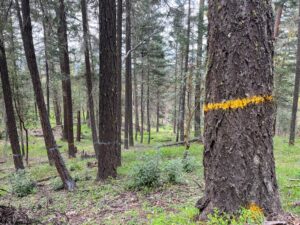
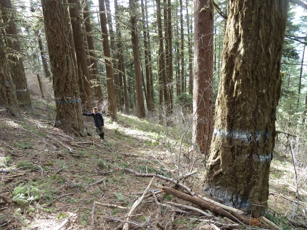
Only trees marked yellow will be retained in unit 13-2 along the East Applegate Ridge Trail, leaving virtually no canopy cover, no shade, and no forest to speak of. The prescription will log many large diameter, living Douglas fir trees, as well as habitat rich snags. In this photograph, only three trees would be retained and the forest floor will be churned by heavy equipment leaving a few scattered trees, heavily disturbed soils and non-native or noxious weeds, where beautiful wildflowers once dominated.
Although the agency claims to be using a scalpel to selectively harvest only the most unhealthy trees, and those most likely to die, the actual outcome and on-the-ground results of the Holcomb Hollow Timber Sale has included the removal of mature, living forest canopy, large fire resistant trees, habitat rich snags, and virtually everything in between.
For example, the SOS Project claimed to “promote hardwoods,” and the Holcomb Hollow Timber Sale Prospectus “reserved” them from timber harvest; however, hardwoods have been systematically removed across hundreds of acres in both the Holcomb Hollow and nearby Apple Saws Timber Sales, leaving a few scattered, often badly damaged trees per acre in some locations, and virtually none in others.
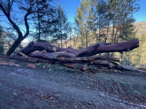
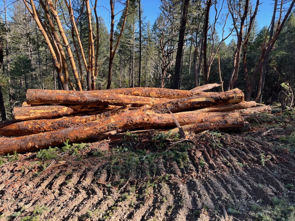
A large diameter madrone logged in the Holcomb Hollow Timber Sale and decked for removal along the Woodrat Mountain access road.
Logging off these hardwoods, and the living, resilient conifers that survived the recent beetle mortality events in the Applegate River watershed has significant unanalyzed impacts, and creates fundamentally different outcomes than those disclosed in the BLM’s Environmental Assessment or authorized in its Decision Record.
The logging proposed along the East Applegate Ridge Trail would heavily degrade the recreational experience by logging off some of the only forested habitats traversed by the trail, and many of the forests in the trail’s immediate viewshed. The project would log stands to as low as 5-20% canopy cover, leaving a few scattered trees where living, green forests once stood. It would also eliminate the only real shade along the trail, and along this otherwise sunbaked ridgeline.
The area also supports populations of the great grey owl, which nests in conifer stands within the area. Significant effort was made during the creation of the East Applegate Ridge Trail to avoid impacts to these great grey owl habitats. Now these same mature conifer forests are being proposed for heavy industrial logging with potentially long-term impacts to this important nesting habitat.
Additionally, the controversial Bear Grub Timber Sale was proposed a number of years ago by the BLM, in the same immediate location. Yet the Bear Grub Timber Sale was canceled, in part, due to impacts to the rare Pacific fisher, and its old forest habitat. Now BLM has proposed to log these same stands, but with much more intensity, creating more damaging impacts to Pacific fisher denning habitats .
The timber sale also includes both cable yarding units in the viewshed of the trail, where currently green forests will be heavily logged and streaked with vertical cable yarding scars. This form of yarding tears up forest soils as the trees are repeatedly dragged uphill on steep mountain slopes and in long vertical corridors. Often the BLM requires one end log suspension, which allows the other end to scrape and drag across the forest floor. This creates long, vertical strips of heavily disturbed soil, significant soil compaction, soil displacement, and erosion that can create small gullies that channelize water and have been documented to contribute to debris flows and slope failures.
The units directly adjacent to the trail would be subjected to ground-based yarding where large tractors drag logs across forest soils, destroying the spectacular native wildflowers the trail is known for, gauging deep into forests soils, creating widespread soil compaction, extensive soil disturbance and often a conversion from native understory species to highly flammable non-native annual grasses and noxious weeds. Disturbance from equipment use and the degradation of native plant habitat is a significant impact along the East Applegate Ridge Trail, which is loved for its abundant native wildflower displays and high quality pollinator habitats.
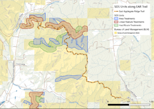
A map of logging units along the East Applegate Ridge Trail. All blue “area units” and red “linear feature” units are commercial “salvage” logging units with significant live tree logging, canopy reduction, large tree removal and snag removal.
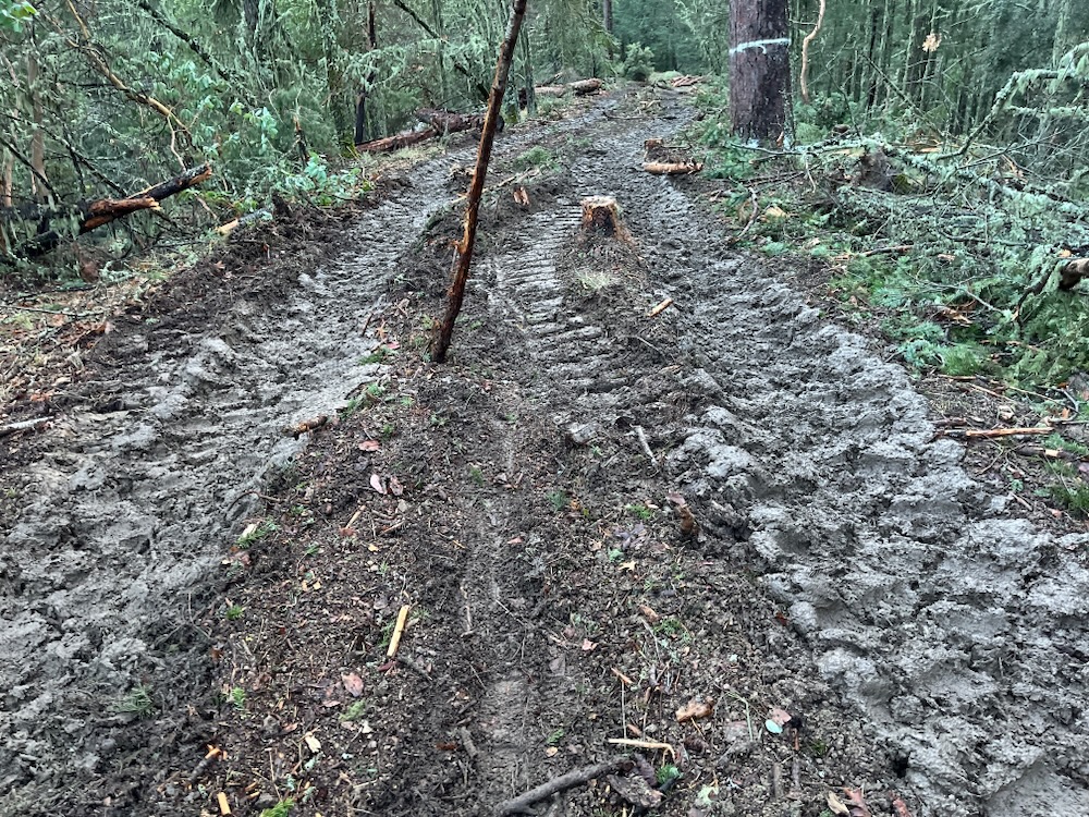
The scars of Holcomb Hollow Timber Sale will also damage the scenic viewsheds and the quality of both the environment and recreational experience directly adjacent to the trail. Especially, for the first two and a half miles, east from Highway 238, significant damage will be done.
Not only will the first half mile of the trail be converted from a trail on an old, gated, overgrown roadbed to a full blown timber haul road, but landings would also be created, large soil sterilizing machine slash piles would be built and later burned, and the surrounding forests heavily logged. The first two miles of now scenic mountain canyon would be riddled with logging units devouring each major stand of conifer forest, including those with both minimal and relatively significant recent tree mortality.
Additionally, approximately 1/4 mile of trail would run directly through unit 13-2, which would log off the trail and the surrounding ridgeline. Meanwhile the BLM would log straight to the trail in unit 11-1, 13-4 and 13-5.
Please contact BLM and let them know you love the East Applegate Ridge Trail and do not want to see it logged!
You can sign onto a quick letter and send it to elected officials and BLM land managers here.
Please add into the letter that you want to see the logging along the East Applegate Ridge Trail CANCELLED!
Better yet, send the BLM a personalized message extolling your love for the unlogged East Applegate Ridge Trail and your desire to see the Holcomb Hollow Timber Sale canceled.
Medford District BLM Field Manager, Elizabeth Burghard:
Which do you prefer on your favorite local hiking trail?
Relatively natural forests and intact plant communities?
Only one tree along this section of trail would be retained in unit 13-2 of the Holcomb Hollow Timber Sale. The BLM and the timber sale purchaser, Parker Excavation and Forestry, would log right to the trail in stands that already contain very little tree density and minimal fire risks. The unit would also be tractor logged using ground-based equipment. This will tear up the forest floor and impact the native plant communities and wildflower displays this area is so well known for.
Or… heavily logged and disturbed landscapes impacted by BLM timber sale operations?
This Riparian Reserve on the western face of Woodrat Mountain was clearcut by Parker Excavation and Forestry in unit LF-26.1 of the Holcomb Hollow Timber Sale. The timber sale removed both dead standing snags and many large diameter, living Douglas fir trees, including those over the 36″ diameter limit.
On a national level the BLM has proposed two new Categorical Exclusions (CEs) that collectively, would rubber-stamp commercial logging in forests and woodlands across the country.
BLM calls the logging of large, old, fire resistant trees “fuel reduction,” and commercial “thinning” often includes the removal of nearly all mature trees in a stand. This stand in the Nedsbar Timber Sale was proposed for heavy industrial logging with trees painted white identified for removal. The timber sale was never logged due in part to public opposition, and could be threatened again if BLM has its way.
Utilizing a CE for project approval triggers a process that categorically excludes the public from the public land management planning process and takes away existing opportunities for public comment. The process also eliminates requirements for a substantive environmental analysis, and the disclosure of environmental effects.
COMMENT NOW! Links to comment on these projects are at the bottom of this blog post. Comments are due May 6th, 2026.
Simply put, a CE allows the BLM to approve land management projects that the agency claims will have minimal environmental effects, but it is not required to back up those claims with analysis. It also allows the agency to do so while excluding you, community groups, environmental advocates, and virtually everyone but the timber industry from the process. On a practical level, what these two CEs would do is allow the BLM to authorize virtually any large-scale logging project it can design, logging its way across the landscape 5,000 acres, or 7.8 square miles at a time.
Historically, public involvement included the release of a scoping notice during the early stages of project planning, and a scoping comment period. In theory, this allows the public some ability to influence projects as they are designed, developed, and analyzed. This process is then followed by the release of an Environmental Assessment (EA) or Environmental Impact Statement (EIS), and another public comment period. This is intended to allow the agency to to gauge public opinion, consider public input, and both design and approve projects that were influenced by the public involvement process. Historically, this also included public meetings, or field trips to discuss the proposed project during these official comment periods.
The BLM’s Lickety Split Timber Sale was approved with a Categorical Exclusion because the agency determined the project would not have a significant impact on the environment; however, the project resulted in large clearcuts, like this one pictured above, and it heavily logged hundreds of acres in the Little Applegate River watershed.
Under a CE, this public involvement and environmental analysis process would be abandoned, and the BLM would simply design, develop and authorize a logging project internally, without any public involvement or notification. The first notification to the public would be the announcement of a Decision Record and timber sale auction, which are now also closed to the public.
In this process, the BLM would no longer conduct or allow for public comment; they would no longer analyze the potential impact of project activities, and they would no longer disclose to the public what the impact of these management activities might be. Instead, the process is designed specifically by the BLM to rubber-stamp damaging BLM timber sale activities and fast-track large-scale logging projects on forested BLM lands throughout the country, including western Oregon and the Applegate River watershed.
The Apple Saws Timber Sale currently being implemented above Ruch, Oregon has devastated the forest canopy and damaged wildlife habitat on the face on Ben Johnson Mountain. The BLM claims projects like this have so little impact that they can be authorized without public comment, scientific review, or the public disclosure of environmental impacts.
Although proposed separately, in practice these CEs would allow BLM to authorize the type of lawless, widespread, industrial-scale logging the Trump Administration envisions on our public lands with virtually no public accountability. It would allow for heavy logging, at a landscape scale in both living green forests and in forests subjected to natural disturbance processes like wildfire, beetle outbreaks and other forms of tree mortality.
Make no mistake, this is a blank check to log virtually any forest the BLM chooses, while excluding credible science, substantive environmental review and public involvement.
If authorized, these CEs would allow BLM to log virtually every public forest in its ownership by approving unlimited numbers of 5,000-acre timber sales, and if previous attitudes at BLM are any indication of the future, the agency will immediately unleash a flurry of CEs and timber sales once this is approved. The agency will most certainly log off the forests you love, and the forests that are so important in maintaining habitat both throughout the region, and across this beautiful country.
The new Categorical Exclusion for density management and green tree logging projects on BLM lands
Historically, the agency has allowed for the Categorical Exclusion of commercial logging to address “forest health” concerns in living, green stands; however, it has been limited in each individual CE to 70 acres and 0.5 miles of new road construction. We have seen this Categorical Exclusion misused to authorize damaging logging and road construction projects with significant environmental effects, however, we have thankfully also seen most green, or living tree timber sales implemented using full public comment periods and environmental review to analyze and disclose the impact of the logging proposed in an Environmental Assessment (EA) or Environmental Impact Statement (EIS).
This new CE proposes “commercial thinning,” but provides virtually no limitations on where these treatments would take place, no diameter limit on tree removal, no canopy cover retention targets, and although it specifically excludes clearcut or regeneration harvest, it would allow group selection logging clearcuts up to 2 acres in size, and heavy industrial-scale logging that retains minimal canopy cover and a few scattered trees per acre.
Group selection logging is a form of staggered clearcut logging that removes whole groves of mature trees. This group selection “opening” was created during the Sterling Sweeper Timber Sale in the Little Applegate Valley and has since filled in with dense, highly flammable young growth.
It would also authorize projects with as much as 5 miles of new permanent road construction and up to 2.5 miles of new “temporary” road per 1,ooo acres of treatment area. This means as much as 12.5 miles of “temporary” road per 5,000-acre project area.
What the BLM has proposed in this new Categorical Exclusion is the implementation of “density management” logging at a much larger scale and with very few guardrails, authorizing Categorical Exclusion for projects up to 5,000 acres, or approximately 7.8 square miles in size. This is more than 70 times the size of the current Categorical Exclusion authorizations for “forest health” or “density management” type logging operations, and would have significant impacts on public resources, biological values, recreational settings, and scenic values for communities and watersheds across the region.
Conditions following commercial thinning in the O’Lickety Timber Sale in the Little Applegate Valley. Following the heavy thinning operations windthrow was significant and further reduced canopy cover and impacted northern spotted owl habitats.
The impact of a single CE would be devastating on a local scale, and the implementation of unlimited numbers of CEs across virtually all BLM forest or woodland nationwide is simply enormous. The CE is essentially a public forest give-away to private industry and must be vigorously opposed.
The new Categorical Exclusion for “salvage” logging on BLM lands
Current Categorical Exclusion authorizations for salvage logging are limited to 250 acres and up to 0.5 miles of new temporary road construction. Again, we have seen this Categorical Exclusion for salvage logging repeatedly misused to target living, green trees, and to implement projects with very significant environmental effects. Large-scale salvage logging, over 25 acres, as proposed by the BLM in this new CE, has historically been implemented using full public comment and environmental review with and Environmental Assessment (EA) or Environmental Impacts Statement (EIS).
ASA has monitored numerous recent projects authorized under the current 250-acre “salvage” logging CE, and these projects have targeted predominantly living trees, and created immense amounts of damage to local habitats, watersheds, wildlife, wildfire resilience, and scenic values in the Applegate Valley. This includes the devastating examples of the Boaz Salvage Timber Sale, the Forest Creek Salvage Timber Sale and the Lickety Split Timber Sale, where industrial logging in living green forests, illegal road construction, unauthorized yarding activities, unenforced Project Design Features, wet weather logging, and poor or non-existent project administration led to landslides, debris flows, permanent damage to streams, the bulldozing and clearcutting of Riparian Reserves, and unanalyzed levels of damage to living forests, native vegetation and habitat values.
The BLM claims units like this one in the Forest Creek Salvage Timber are not clearcuts, but the results on the ground show otherwise. The BLM implemented this project on an assumption of “no significant environmental impacts,” again the results on the ground show otherwise.
The newly proposed CE is intended to scale up these impacts by allowing large-scale salvage logging in areas up to 5,000 acres, or across 7.8 square miles in size. It would also allow the construction of up to 1 mile of new permanent road construction and up to 2.5 miles of so-called “temporary” road per 1,000 acres of treatment area. This would authorize up to 20 times the acreage in the current CE and would dramatically increase impacts associated with widespread road construction.
Like the new density management CE, this new “salvage” logging CE provides virtually no limitation on where these treatments might take place, meaning they will be used across the entire BLM landscape.
We know firsthand in the Applegate how this narrative of “dead and dying” trees, and “salvage” logging can be used by the BLM to target living, viable stands of mature forest, devastating local watersheds, wildlife habitat, and scenic values. We also know the damage associated with salvage logging in stands with significant mortality and the lasting impact this logging has on habitat values, forest regeneration and future fire risks.
Now imagine, the landslides, clearcuts, the widespread green tree logging, and environmental damage of last winter’s Boaz Salvage Timber Sale implemented across 20 times more land. Imagine projects like the current SOS logging project, which is decimating the habitats around Ruch being approved one after another, with no opportunities for our communities to have a voice in the process. This is the vision of the Trump Administration and their willing partners at BLM, who are eager to cut the public out of the process, while they cut down our public forests.
A landslide triggered by salvage logging on BLM land in the Boaz Salvage Timber Sale. Implemented with a CE, the BLM claimed this project would have such minimal impact that public comment and scientific review were unnecessary. This 250-acre salvage timber sale was the most damaging timber sale implemented in recent decades on BLM lands in the Applegate Valley and was responsible for landslides, debris flows, the bulldozing of whole seasonal stream channels, the conversion of riparian areas into skid trails, the clearcutting of living, green forests, and the retention of only 3.4 trees per acre.
Combined these two Categorical Exclusions, along with the proposed RMP Revisions would irreparably damage our public lands, degrade wildlife habitats, impact fisheries and degrade the beautiful public lands we enjoy today. It would also degrade trust in the BLM, and leads to a very valid questioning of the agency’s commitment to public values, public involvement, and a livable planet for future generations.
Please comment now on these irresponsible Categorical Exclusion proposals—if implemented they will change BLM forests and woodlands forever.
COMMENT NOW! Talking Points for the Density Management CE
Commercial logging projects proposed at the scale envisioned under this new CE would create significant environmental impacts on local watersheds, wildlife, fire resilience, habitat connectivity, biodiversity, and on local human communities.
Current BLM logging practices are creating significant environmental effects and demonstrate a need to implement full comment periods and environmental analysis/review for all projects of the scope, scale and intensity proposed. This requires the release of an Environmental Analysis or Environmental Impact Statement with site specific, project level analysis for each individual logging project.
Commercial logging can increase fire risks by logging large fire resistant trees, reducing canopy cover, increasing understory fuel development and creating hotter, drier, more fire prone environments.
Commercial logging and road construction at the scale and intensity proposed will damage watersheds and fisheries by increasing sedimentation and reducing water quality.
Commercial logging, density management, and road construction at the scale proposed will have negative impacts on endangered species, wildlife habitat, mature, late successional, and old growth forests, scenic values, recreational values and local economies.
Proposals to increase the scope, scale and use of Categorical Exclusions are undemocratic, unlawful, inappropriate, and fail to maintain the public interest in public land management planning.
For more information on this new Density Management CE proposal and to provide public comment, click on the buttons below.
COMMENT NOW! Talking Points for the Salvage Logging CE
Salvage logging has significant biological impacts and no credible biological benefit to forest or woodland ecosystems.
BLM salvage logging often includes significant green, or living tree removal and is typically implemented as clearcut logging which increases fire risks, degrades habitat values, damages watersheds, and impact the areas scenic qualities.
Salvage logging projects proposed at the scale envisioned under this new CE would create significant environmental impacts to local watersheds, wildlife, fire resilience, habitat connectivity, biodiversity, and on local human communities.
Current BLM salvage logging practices are creating significant environmental effects and demonstrate a need to implement full comment periods and environmental analysis/review for all projects of the scope, scale and intensity proposed. This includes at least an Environmental Assessment or Environmental Impact Statement for each individual timber sale project.
Salvage logging can increase fire risks by logging large fire resistant trees, reducing canopy cover, increasing understory fuel development and creating hotter, drier, more fire prone environments.
Salvage logging and road construction at the scale and intensity proposed will damage watersheds and fisheries by increasing sedimentation and reducing water quality.
Salvage logging and road construction at the scale proposed will have negative impacts on endangered species, wildlife habitat, mature, late successional, and old growth forests, scenic values, recreational values and local economies.
Proposals to increase the scope, scale and use of Categorical Exclusions are undemocratic, unlawful, inappropriate, and fail to maintain the public interest in public land management planning.
For more information on this new Salvage Logging CE proposal and to provide public comment:
The Trump Administration’s Bureau of Land Management (BLM) has set their sights on Western Oregon forests and has started the process to revise the BLM’s 2016 Resource Management Plan (RMP). The goal is to dramatically increase timber production on 2.4 million acres of BLM lands, “to provide a sustained yield of timber production consistent with the maximum productive capacity of the lands.”
The BLM intends to quadruple timber production in Western Oregon from the already too high 250 million board feet per year, to approximately 1 billion board feet annually.
Landslides and debris flows triggered by clearcut logging on Medford District BLM lands in the Boaz Salvage Timber Sale. The BLM is proposing to ramp up this type of logging throughout Western Oregon under the Trump Administration’s RMP Revision.
Like so many of the administration’s regressive policies, these RMP Revisions propose to take us back to the wildly unsustainable timber harvest levels of 1960-1990 when whole watersheds of old-growth forest were being liquidated in vast clearcuts, roads were being punched into remote habitats, wildlife populations were plummeting, watersheds across the state were failing and fisheries were collapsing in unison across the Pacific Northwest.
Old-growth forests like these on the northern face of Grayback Mountain could be logged under the BLM RMP Revision.
In practice, what the current RMP Revision will do is strip the region of environmental, watershed, and habitat protections and facilitate widespread clearcut logging and new road construction on the vast majority of the agency’s land in Western Oregon. This would impact beautiful BLM lands and important habitats between the Columbia River and the California border in the Coast Ranges, on the western slope of the Cascade Mountains, and in the Siskiyou Mountain of southwest Oregon, including the Applegate River watershed and broader Siskiyou Crest region.
Old forest previously proposed in the Late Mungers Timber Sale were spared by recent IVM litigation, but would be threatened all over again by the logging proposed in the RMP Revision.
This level of harvest can only be described as deforestation and wholesale environmental destruction. A return to this level of industrial timber harvest will lead to a dramatic expansion in clearcut logging, the development of highly flammable plantation stands across broad landscapes, high-graded and heavily logged stands with virtually no biological integrity, enormously detrimental watershed effects, and scenic Oregon viewsheds riddled in unsightly logging scars and new road cuts.
Ironically, these issues have been resolved in the courts and both BLM and big timber’s interpretation of the 1937 O&C Act, as a timber-only mandate has been thoroughly rebuked. Unable to accept these limitations on their plunder of public lands the BLM, the timber industry, the O&C Counties (such as Jackson, Josephine, and Curry County is southwestern Oregon), and the Trump Administration are intent on increasing timber production, regardless of the enormous impacts.
Representing the politics of corruption, greed, and unsustainable excess, the BLM has been fully captured by the timber industry and is prioritizing short-term profits for wealthy shareholders, over the health of our forests, watersheds, and communities in Western Oregon.
Rivers and streams would be heavily impacted by increased logging proposed by the BLM in the RMP Revision, including this portion of the Little Applegate River on Medford District BLM lands.
Many of the rural communities in the region have transitioned from unsustainable timber-dependent economies to more balanced economies centered around tourism, outdoor recreation, fisheries, agricultural enterprises and amenities. In this way, the beauty of the region is central to its economic vitality, and the shift away from heavy, industrial scale resource extraction also supports a higher quality of life for local residents, maintains a beautiful, healthy environment for the benefit of surrounding communities, and provides cold, clean water to regional farms, ranches, vineyards, and river ecosystems.
Western Oregon is known for its beautiful coastlines, towering forests, verdant streams, wild rivers, world-renowned fisheries, intact mountain vistas, and abundant wildlife. Many in the region take pride in where they live, the natural beauty it offers, and its incredible biodiversity. We feel blessed to live in such spectacularly scenic landscapes and value them immensely.
Beloved places like the Burton-Ninemile Lands with Wilderness Characteristics in the Applegate Valley and all conservation-based Land Use Allocations would be threatened under the Western Oregon RMP Revision.
The BLM’s RMP Revision is a threat to what we love in Oregon and must be stopped. We implore our neighbors, residents throughout the state, visitors who love the region, conservationists, hikers, hunters, fishers, whitewater rafters, botanists, birders, elected officials, and all who love Oregon’s public lands to speak out for its defense.
Please comment on the Scoping Notice for the RMP Revision and tell BLM:
The proposed increase in logging is unsustainable, irresponsible, and will degrade public resources like clean water, fisheries, intact forests, wildlife habitats, and public wildlands.
Timber production in the Annual Sale Quantity (ASQ) should be adjusted downward to compensate for the 2021 Labor Day Fires, recent beetle outbreaks in southwest Oregon, and mortality related to climate and drought effects.
Oregon’s public lands should be managed for public values, not private timber industry interests.
The courts have confirmed that O&C Lands should be managed for multiple uses, including conservation, wildlife, watersheds, recreation, and others. These lands do not have a timber-only mandate.
Maintain and expand all current conservation-based Land Use Allocations, including Areas of Critical Environmental Concern, Lands with Wilderness Characteristics, Wild and Scenic Rivers, Wilderness Areas, Late Successional Reserves, Research Natural Areas, and Riparian Reserves.
Heavy commercial logging, as proposed by the BLM in the RMP Revision, will dramatically increase fire risks by removing large fire resistant trees, altering microclimate conditions, and regenerating dense, highly flammable young growth. This creates conditions that are conducive to hotter, more fast-moving fires.
Many rural communities have transitioned away from public land timber production and into more sustainable, balanced economies. These economic activities will be significantly harmed by increased timber production.
The BLM has proven themselves so irresponsible in their management of public lands and has so thoroughly violated the public’s trust, that I support the transfer of all BLM lands in western Oregon to the adjacent National Forests.
Note: Our own Medford District BLM Manager Elizabeth Burghard, is the official Oregon/Washington BLM contact for this RMP Revision and Western Oregon clearcut logging plan. After increasing timber production here on the Medford District in the past two years, apparently the Oregon/Washington Office and the Trump Administration took note, putting her in charge of the largest BLM Timber Grab in recent history! She is the official contact for this project and all communications should be addressed to Elizabeth Burghard, the individual most responsible for the current logging impacts in the Applegate, and the point person for the destruction of forests across the state!
Take Action!
Provide comments to the BLM through the following methods:
Sending in your own letter is the most powerful way to have your voice heard, but you can also send a quick letter through the Center for Biological Diversity‘s letter campaign here:
Click play to watch a short video from on-the-ground monitoring of the Apple Saws Timber Sale on Ben Johnson Mountain above Ruch.
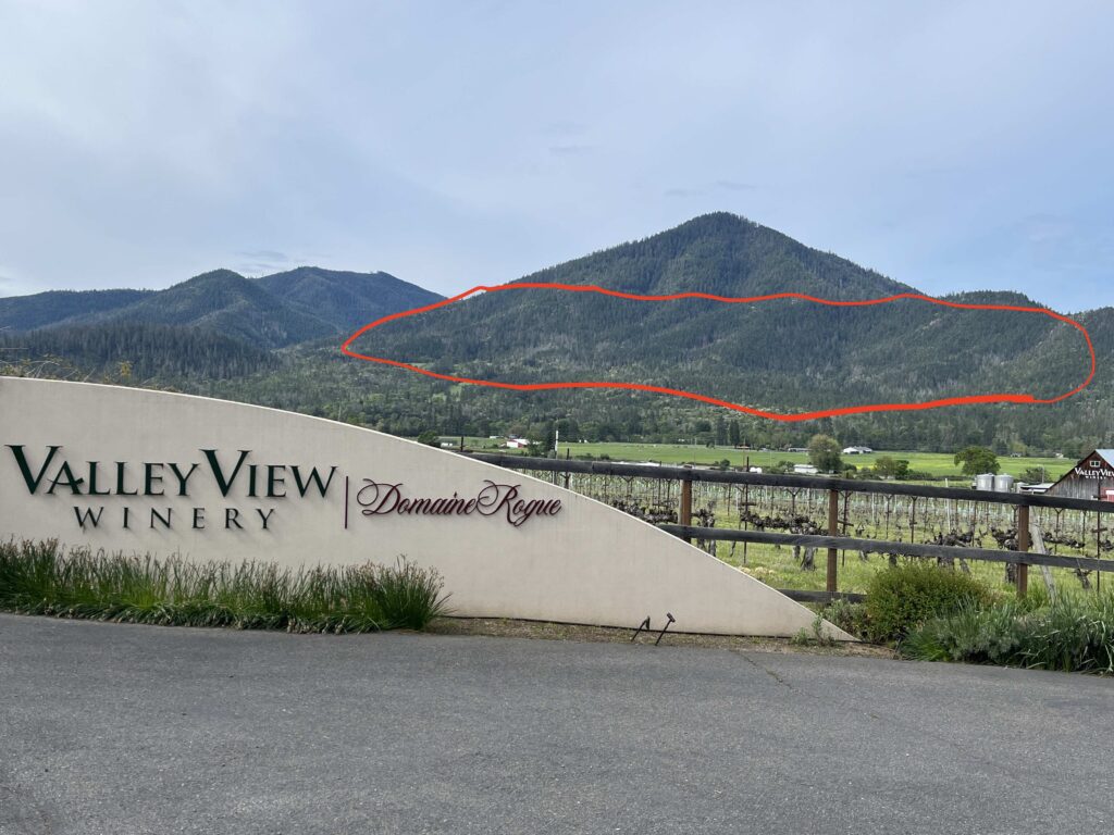
Ben Johnson Mountain and the famous valley views of Ruch, Oregon with the units identified in red. This photograph was taken before implementation of the Apple Saws Timber Sale.
Ben Johnson Mountain rises like a broad, forested dome directly above the popular Cantrall-Buckley County Park and its swimming holes along the Applegate River. The mountain is visible from residences, vineyards and farms across the Ruch area, and from nearby hiking trails like the East Applegate Ridge Trail.
On New Year’s day, the Medford District BLM and Estremado Logging began logging off the mountain’s eastern face, desecrating our beloved mountain with logging scars. Although the BLM claims to be logging only dead and dying trees in this timber sale, the forests on these slopes contain very little recent tree mortality. In fact, these forests survived the 2022-2023 flat headed fir borer outbreak as refugia habitats, and relatively little tree mortality has occurred.
Ironically, the BLM admits that some stands in the Apple Saws Timber Sale may contain as little as 10% mortality, and some appear to have far less when surveyed on the ground, and yet, astoundingly the BLM proposes to log 82% of the trees in these forests, leaving little but scattered trees, vertical skyline yarding scars, and soils churned, compacted, and displaced by heavy equipment use.
Whole stands of living, green forest is being logged off in the Apple Saws Timber Sale above Cantrall-Buckley County Park.
Additionally, the BLM is allowing the logging contractors to exceed authorizations in the applicable BLM documents. What we have found in the Apple Saws Timber Sale is the myth presented by the BLM in their timber sale approval documents, and the realities, which are demonstrated clearly on the ground.
Much like the recently implemented Boaz Salvage Timber Sale, which ended in landslides, debris flows and permanent damage to forests, riparian areas and streams, the Apple Saws Timber Sale is being implemented with disregard for public resources and the agency’s own regulations, and it is having tragic consequences.
The BLM has woven a narrative about reducing fire risks, mitigating environmental effects, and implementing Project Design Features (PDFs) to protect public resources, but these are myths, not supported by the evidence on the ground. The Apple Saws Timber Sale is a disaster in the making, and like the Boaz Salvage Timber Sale implemented last winter, it is being implemented in a manner that dramatically exceeds the environmental impacts analyzed or authorized in the Ashland 2025 SOS Environmental Analysis (EA), the Ashland 2025 SOS Decision Record #3 for the Apple Saws Timber Sale, or Apple Saws Full Timber Sale Prospectus.
Apple Saws Timber Sale: The Myth and the Reality
A large opening logged off in the Apple Saws Timber Sale. Every stump in this photograph was a live tree, with green vibrant foliage contributing to the overstory canopy in the stand.
Only the first few units have been implemented in the Apple Saws Timber Sale, but already both the myths of the BLM’s analysis and impacts of the project are becoming crystal clear. Currently, the agency is not just looking the other way while authorizations are violated, they are knowingly allowing, and excusing the lack of compliance on the ground, leading to impacts that exceed those authorized by the BLM.
Myth #1 – Only dead and dying trees are being cut and removed
“Retain all healthy trees which show no signs of insect infestation or decline unless removal is required for safety or operational purposes.” (Ashland SOS EA P. 11)
“Within stands experiencing mortality, healthy living trees are not the target of salvage harvest.” (Ashland SOS Decision Record #3 P.8)
“Area units are RETENTION MARKED in WHITE for salvage harvest. All unmarked Douglas-fir trees meeting minimum merchantability specifications have been deemed dead or dying.” (Apple Saws Full Timber Sale Prospectus P. 2)
“Reserve all healthy, green trees in all DXP-LF units” (Timber Sale Prospectus P. 5)
Reality #1 – Significant living, green trees are being felled and removed across the Apple Saws Timber Sale
Whole stands of living, green mature forest is being felled and removed in unit 32-7 and across the Apple Saws Timber Sale. These are not dead and dying trees, but instead were some of the most resilient living forests remaining adjacent to the valley floor near Ruch. Where logging has occurred most of the forested stands are now reduced to only a few scattered trees.
Whole stands of living, green, non-beetle infested trees are being logged all across the Apple Saws Timber Sale. In fact, the Ashland 2025 SOS EA allows for logging in stands with as little as 10% mortality, and the timber sale prospectus reveals that 82% of the trees in these stands will be logged, in the timber sale if fully implemented.
Currently, the first few units have been logged and have included predominantly the removal of living, green trees, as well as extensive trees marked white for “retention,” but logged by Estremado Logging throughout the timber sale.
In response to our complaints that many living, green trees and retention trees are being removed, BLM has responded by stating, “The Apple Saws Timber Sale is removing dead and dying Douglas-fir trees as analyzed in the Ashland 2025 SOS Environmental Assessment and authorized in Decision Record 3.” They also claim, “Conifer trees that were reserved marked and cut for operational purposes (yarding corridors) have been swapped with conifer trees that were not reserve marked to maintain adequate post-harvest residual densities.”
A portion of unit 32-7 of the Apple Saws Timber Sale after tree felling, but before yarding operations occurred. As is clearly visible, almost every tree cut and on the ground contains living, green foliage and no sign of beetle infestation.
What we can see on-the-ground in the Apple Saws Timber Sale is the widespread removal of living, green, non-beetle infested trees. In fact, almost none of the trees we have seen felled throughout this timber sale were dead standing snags. Additionally, large Douglas fir trees clearly marked for “retention” have been cut at scale across unit 32-7, and it does not appear they were replaced with comparable trees or “swapped” out as the BLM suggests.
We are also concerned that canopy cover and density targets are not being met and northern spotted owl habitat development is being “precluded and delayed” for more than 20 years in violation of the BLM’s 2016 Resource Management Pland and its management direction for Late Successional Reserve (LSR) forests. The flanks of Ben Johnson Mountain and the surrounding areas are LSR forest and should be managed for the maintenance, enhancement, and recruitment of late successional forests. This timber sale is having the opposite affect and will set back LSR habitat values for many decades to come.
Myth #2 – Hardwoods are not being cut and removed across the Apple Saws Timber Sale
Despite the BLM’s claims that large madrone and black oak would be “reserved” during logging operations, they are being felled and removed across the Apple Saws Timber Sale. Approximately 80% of the hardwood population has been removed in affected units. The removal currently occurring dramatically exceeds the affects analyzed and authorized in BLM NEPA documents, and dramatically exceeds what is necessary for operational safety. .
“Retain all hardwood species unless removal is required for safety or operational purposes.” (Ashland SOS EA P. 11)
“The Ashland SOS project proposes to retain healthy living trees, leave snags in proposed units, and promote hardwood species.” (Ashland SOS Decision Record #3 P. 25)
“Hardwood regeneration is important for providing species diversity, varied age classes, and structural layering. Hardwoods will be retained except where operationally infeasible.” (Ashland SOS Decision Record #3 P. 34)
“Reserve all cedar, pine, hardwoods, and Pacific yew in all units as shown on Exhibit A, except where falling is necessary for safety or operational reasons. If such trees need to be cut for safety or operational reasons, retain cut trees in the stand.” (Apple Saws Full Timber Sale Prospectus P. 1 of 29)
Reality #2 – Significant hardwood populations are being felled and removed across the Apple Saws Timber Sale
Madrone logs are being felled, sorted, decked and sold by Estremado Logging, despite being reserved from logging. The BLM documents clearly state that the logging company bought only Douglas fir logs and was to remove only Douglas fir logs, yet vast quantities of madrone are being removed and turned into commercial products.
Hardwoods, including at least 80% of the madrone and black oak on site are being felled and removed across the Apple Saws Timber Sale. This includes large mature madrone trees by the thousands, many of which are being felled, yarded to the road, sorted, decked, and hauled off in log trucks despite not being authorized for felling or removal.
The wholesale removal of hardwood trees for firewood was explicitly not allowed under the timber sale contract or BLM NEPA documents. Yet, the systematic removal of hardwoods is occurring throughout the timber sale area.
The felling, yarding and removal of hardwoods for firewood is occurring openly throughout this timber sale, despite the fact that Estremado Logging did not buy the hardwoods and is not authorized to fell, yard or remove them from the site at this scale.
The Apple Saws Timber Sale is completely decimating, rather than “promoting” and “retaining” the hardwood component as the EA, Decision Record, and Timber Sale Prospectus suggest. Additionally, the retention and promotion of hardwoods was required to meet canopy cover, basal area, and Northern spotted owl habitat targets identified by BLM during the planning process.
The removal of hardwoods at scale renders the EA analysis invalid and demonstrates that BLM logging operations dramatically exceed the impacts analyzed, authorized, and disclosed to the public in the applicable BLM documents. The retention and promotion of hardwoods in the Apple Saws Timber Sale is a myth untethered from reality.
Myth#3 – No wet weather logging will occur
“No road construction, landing construction, skid trail construction, road renovation, road reconstruction, road decommissioning, road blocking/barricade construction, rocking, water bar construction, soil ripping, shall be conducted within contract area between October 15th of one calendar year and May 15th of the following calendar year, both days inclusive, or when soil moisture exceeds 25%, as determined by the Authorized Officer.
No ground-based yarding or soil decompaction operations shall be conducted within contract area between October 15th to May 15th, or when soil moisture exceeds 25%.” (Apple Saws Full Timber Sale Prospectus P. 7 of 29).
“Restrict non-road, in-unit, ground- based equipment used for harvesting operations to periods of low soil moisture; generally from May 15 to Oct 15. Low soil moisture varies by texture and is based on site-specific considerations. Low soil moisture limits will be determined by qualified specialists to determine an estimated soil moisture and soil texture” (2016 RMP, p. 183).
Reality #3: – Ground-based wet weather logging and hauling has occurred.
Soil damage from wet weather ground-based logging during an extended rain event from January 1 to January 5, 2026.
Last winter the BLM allowed wet weather logging to occur (despite ASA’s complaints) until landslides, heavy sedimentation and debris flows occurred in the Boaz Salvage Timber Sale. This winter, in the Apple Saws Timber Sale on Ben Johnson Mountain, Estremado Logging requested a wet weather waiver on December 16, 2025, and BLM immediately authorized that waiver three days later on December 19.
Wet weather logging is generally restricted during the winter months to protect soils, reduce sedimentation into local streams, and mitigate the impact of logging, yarding, and hauling activities. The waiver BLM provided for the Apple Saws Timber Sale allows the logging company to ignore the Project Design Features identified in the BLM’s Resource Management Plan, and the authorizations in the Timber Sale Prospectus that limit wet weather logging and hauling activities from May 15th to October 15th.
However, even this wet weather waiver states, “no work will occur during rain events.” Despite these restrictions crews moved in equipment on Christmas eve and began logging during a rain storm on January 1, 2026. Logging continued in the rain until January 5, 2026 in violation of the Wet Weather Waiver provided by the BLM.
Throughout the timber harvest activities ground-based yarding has created excessive soil damage, deep rutting, heavy soil compaction, damage to coarse downed wood, and the potential for significant surface erosion, and stream sedimentation in nearby seasonal streams. This disturbance also destroys native vegetation and will undoubtedly encourage noxious weeds and non-native annual grasses that can dramatically increase fire risks.
Myth #4 – No ground based yarding will occur in unit 32-7
The Ashland 2025 SOS Decision Record #3 for the Apple Saws Timber Sale identified unit 32-7 as a 50.8 acre unit with the logging method identified as “cable/heli.” (Ashland SOS Decision Record #3 P. 2)
The Apple Saws Timber Sale Prospectus identified unit 32-7 as a 69-acre skyline cable yarding unit.
There is no BLM document either analyzing or authorizing ground-based yarding in unit 32-7.
Reality #4 – The lower half of unit 32-7 was subjected to ground based yarding
This photograph was taken on January 2, 2026 during a significant rain event. It also depicts significant unauthorized ground based yarding, which extends over 1000′ up the slopes and into unit 32-7, which was analyzed and approved as a cable yarding unit.
Unauthorized ground-based yarding using a large harvester occurred in unit 32-7 for multiple weeks, including from January 1 to January 5, 2026 during an active rain storm in clear violation of all BLM documents pertaining to this sale.
The unauthorized ground-based yarding also created skid trails likely 4-5 times the size allowed in the Timber Sale Prospectus and on slopes greater than 35%. It also created far more soil damage, compaction and Detrimental Soil Disturbance, damage to vegetation and potential for erosion and stream sedimentation than was allowed in the Apple Saws Timber Sale Decision Record and Timber Sale Prospectus.
BLM was notified of the unauthorized activities and has continued to look the other way, allowing similar activities to occur and has taken no action to address this clear violation of their authorizing documents.
Myth #5 – Logging will not occur in the Inner Zone of Riparian Reserves, and will retain higher retention levels in adjoining Middle and Outer Riparian Reserve buffers
The Ashland 2025 SOS EA identified a 50′ no cut buffer along Riparian Reserves surrounding intermittent or seasonal streams. (Ashland 2025 SOS EA P. 17)
The SOS EA was revised to clarify that retention levels in riparian reserve middle and outer zones must retain at least 30 percent canopy cover and 60 trees per acre, and that only likely or imminent hazard trees may be felled in inner zones, with all other trees retained. (Ashland SOS Decision Record #3 P. 39)
Reality #5 – Logging has occurred in the inner zone of Riparian Reserves in unit 32-7
This Riparian Reserve was cleared of all trees in a large group selection clearcut. To the right is a line of trees marking the outer boundary of a Riparian Reserve. To the left a Riparian Reserve was supposed to extend 50′ across this seasonal drainage. Instead is was clearcut of living, green, mature Douglas fir and madrone trees.
Logging has occurred in the inner zone of the Riparian Reserve in unit 32-7 of the Apple Saws Timber Sale. In fact, a portion of this Riparian Reserve was clearcut in a large group selection opening with virtually all trees felled and cable yarded to the road above.
Additionally, canopy cover and basal area retention targets in adjoining middle and outer Riparian Reserves are also not being met, leading to decreased stream shading, degraded wildlife habitat values, compromised Riparian Reserves and degradation to aquatic habitats.
Myth#6 – New road construction would be limited to segments less than 1/4 mile in length and no new construction was authorized in unit LF-33
“Temporary roads would be limited in length per road segment (< 1⁄4 mile) when accessing units.” (Ashland 2025 SOS EA P. 172)
Additionally, neither the Timber Sale Prospectus nor the Decision Record authorize new road construction in unit LF-33 of the Apple Saws Timber Sale.
Reality #6 – New road segments larger than 1/4 mile have been proposed despite limitations identified in the Environmental Assessment and an unauthorized road was built in unit LF-33
This new unauthorized road segment was built by Estremado Logging in unit LF-33. It required cut and fill construction at the landing site and included excavating, grading, leveling, and stump removal. It is a newly constructed, illegal road segment not analyzed or authorized in any of the applicable BLM documents.
New road segments over 1/4 mile are proposed to access unit 32-1 and would cut across steep slopes, leaving scars on the mountain for decades to come and creating permanent lasting impacts to the viewshed, hydrology, slope stability, and habitat on Ben Johnson Mountain and the surrounding ridges. The new road construction authorized in the Apple Saws Timber Sale includes one contiguous road segment approximately one mile long, and over four times the distance allowed in the EA.
Unauthorized new road and landing construction has also occurred on the ridgeline in unit LF-33. The unauthorized new road in unit LF-33 has been illegally created by logging crews, while BLM looks the other way. This new road segment is approximately 1/4 mile long and was not analyzed or authorized in any of the applicable BLM documents.
Myth #7 – Apple Saws Timber Sale and the larger SOS Project will prevent fires and reduce fire risks
The BLM claims that the SOS Project and Apple Saws Timber Sale are focused on reducing fire risks associated with dead standing trees. The assumption is that excessive dead and dying trees will fall to the forest floor and increase fire risk by building coarse woody debris and large downed trees as surface fuels.
Reality #7 – The Apple Saws Timber Sale will dramatically increase fire risks in all affected forests
Although the project claims to be a “salvage” logging project, the Apple Saws Timber Sale is logging off predominantly living, green stands of mature mixed conifer forest. This logging includes the removal of dominant conifers and hardwood species, as well as significant canopy cover reduction. The science is clear that removing mature forest and replacing it with dense, even-aged, highly flammable, young vegetation and logging slash will dramatically increase fire risks in affected stands.
In 3-5 years, significant woody vegetation will grow up through the logging slash dramatically increasing fire risks. Additionally, significant alterations in habitat will create hotter, drier, more windy habitats with conditions highly conducive to fast moving, high severity fire.
In the case of the Apple Saws Timber Sale, the lands subjected to industrial logging, canopy and large tree removal, heavy ground disturbance, and the associated increase in fire risks also surround residential communities and homes in the Applegate Valley.
BLM has itself concluded that creating openings of the size proposed in the Apple Saws Timber Sale will increase fire risks for 5-20 years; however, we believe it will increase fire risks for far longer than that.
“For the first 1 to 5 years after harvest, these stands would remain a slash fuel type until the shrubs, grasses, and planted trees become established. After the establishment of regeneration, these stands would move into a brush fuel type. Brush fuel types are more volatile and are susceptible to high rates of fire-caused mortality. Stands could exhibit higher flame lengths, rates of spread, and fire intensity. Fires started within these stands could be difficult to initially attack and control.For 5 to 20 years following planting, the overall fire hazard would increase in these stands.” (Clean Slate EA, Fuel Analysis)
The Apple Saws Timber Sale will not make our valley more fire safe, it will regenerate dense, vegetation in areas directly adjacent to homes and residential communities, making them more at risk in the coming fire seasons.
Conclusion
The implementation of the Apple Saws Timber Sale, like the Boaz Salvage Timber Sale before it, demonstrates that BLM regularly builds mitigation measures and restrictive Project Design Features into the environmental (NEPA) analysis, and then relies upon them to make their projects appear benign or even helpful. This myth of BLM benevolence is shattered by the realities on the ground, and by the BLM’s clear refusal to enforce or implement environmental regulations that protect public resources.
The Apple Saws Timber Sale is a tragedy in the making, and we continue to work to stop it. Please contact your elected officials and the Medford District BLM
Take Action!
Tell BLM to stop the logging at the Apple Saws Timber Sale and submit the first logged units to a compliance review.
Tell BLM that community monitoring of this timber sale demonstrates that significant compliance issues have arisen in recent weeks, leading to unacceptable impacts that were not analyzed or authorized in the Ashland 2025 SOS EA, the Ashland SOS Decision Record #3 for the Apple Saws Timber Sale or the Apple Saws Full Timber Sale Prospectus.
Tell BLM that the Apple Saws Timber Sale is sacrificing local habitats, seasonal streams, scenic values, and community fire safety for public land timber production, and private industrial profits. Our public land should be managed for the greatest good, not the greatest greed!
Contact local BLM land managers
Elizabeth Burghard, Medford Area Manager: eburghar@blm.gov
Lauren Brown, Ashland Resource Area Manager: lpbrown@blm.gov
Click on the video above to watch Luke Ruediger’s presentation about the Cedar Flat Project.
Habitats like this on the north slope of Grayback Mountain and along the Grayback Mountain Trail were originally proposed for logging in the Cedar Flat Timber Sale, but have been cancelled due to community input.
Over the holidays, the BLM released an Environmental Assessment (EA) for the Cedar Flat Project above Williams in the western portion of the Applegate Valley. Originally proposed in June 2024, the project included a significant old forest logging component targeting stands high on the face of Grayback Mountain. Immediately, residents and conservation organizations like ASA pushed back and by January of 2025, the BLM had restructured the project and withdrew numerous of the most controversial old forest logging units.
Pleased by this initial restructuring and the cancellation of these mature and old forest logging units on Grayback Mountain, ASA went out to the field again and found additional old forest logging units on the eastern flank of Holcomb Peak at the headwaters of Bear Wallow Creek, scattered throughout the West Fork Williams Creek watershed and on the summit of Little Sugarloaf Peak.
Uni 30-01 on the summit of Little Sugarloaf Peak contains beautiful old forest and should be canceled.
We again made our concerns clear, and BLM responded by withdrawing all Nesting and Roosting habitat for the Northern spotted owl from project units in the Environmental Assessment (EA). This meant that these units of concern shrunk still further, and more of the project became focused on the vast plantation stands found in the area.
With the EA now out for public comment, we have reviewed the appropriate BLM documents and ASA’s is now OPPOSING BLM’s Alternative D, due to the heavy logging prescriptions proposed, and is instead PROMOTING a community alternative we call, Amended Alternative B.
Below are the details of both proposals, followed by talking points and information to help provide substantive comments on the BLM’s Cedar Flat EA.
ASA is Opposing BLM’s Alternative D
Unit 12-0 contains mature forest habitat and would be logged under Alternative D by removing trees up to 36″ DBH and by creating “group selection opening.” This photo shows a group selection opening, where all unmarked trees would be logged and only trees marked yellow would be retained.
The Cedar Flat Project is proposed in Late Successional Reserve (LSR) forest that was set aside to protect, maintain and enhance old forest habitat for the northern spotted owl. In these areas, the agency must not implement logging prescriptions that “preclude or delay” the development of northern spotted owl habitat for more than 20 years, or are driven by purely economic incentives.
Yet, the evidence in the Cedar Flat Project EA demonstrates that numerous mature and old forest units would be logged in a manner that damages northern spotted owl habitat, and these impacts would be most severe under the BLM’s Alternative D. This alternative proposes the heaviest logging treatments, the removal of the largest diameter trees, the most canopy removal, and the largest “group selection” clearcuts of any proposed Action Alternative in the EA.
Our analysis shows that Alternative D would not only damage northern spotted owl habitat, but it would create the most pronounced impact on local watersheds through significant new road construction and more widespread logging operations. It would also increase fire risks by removing large fire resistant trees, degrading canopy conditions, creating large canopy gaps, and making slopes hotter, drier, more windy, and more fire prone. The removal of canopy will, in turn, regenerate a dense, highly flammable layer of young, even-aged shrubs, young conifers and stump-sprouting hardwood species increasing fire risks and encouraging more intense, fast moving fires.
Unit 23-01 of the Cedar Flat Timber Sale contains mature forest habitat and should be canceled to protect and maintain northern spotted owl habitat and old forest conditions at the headwaters of West Fork Williams Creek.
Alternative D allows for the removal of trees up to 36″ DBH for conifers and 24″ DBH for hardwood trees; the retention of as low as 30% canopy cover; the downgrading or removal of foraging and dispersal habitat for the northern spotted owl; group selection logging clearcuts up to 2 acres in size and on up to 25% of each unit, and for up to 5.1 miles of new road construction.
The Amended Alternative B was created by merging the BLM’s Alternative B and C, and amending these alternatives to make them more consistent with LSR standards. This action alternative has been fully analyzed in the Cedar Flat EA, has been shown to meet the purpose and need, and is currently decision ready.
Amended Alternative B would withdraw all mature and old forest logging units and limit commercial logging treatments to relatively young plantation stands under 70 years of age, where thinning trees may have more benefit. It proposes a 24″ DBH limit for conifer removal and 10″ DBH limit for hardwood trees. It focuses non-commercial thinning adjacent to homes and communities, and builds no new roads, while requiring the retention of at least 50-60% canopy cover in Douglas fir and true fire plant communities, and as at least 40% canopy cover in ponderosa pine stands.
Plantation stands like these are the types of stands targeted for treatment in the Amended Alternative B.
Additionally, our Amended Alternative B proposal would not create openings in the canopy or utilize group selection logging techniques. Instead, openings would be created through natural process and prescribed fire, allowing for a more natural, irregular patch mosaic.
Cedar Flat Project Public Comments are Due January 25, 2026
Use your voice for the forests of Williams Creek and provide substantive public comments on the Cedar Flat Project. Below are talking points to help inform your comments and support a healthy environment in the Williams Creek watershed
Support ASA’s Amended Alternative B which promotes plantation thinning, retains large diameter trees, retains adequate canopy cover, does not create canopy gaps, and would both enhance habitat values in heavily altered plantation stands, and reduce fire risks.
Oppose Alternative D and its heavy commercial logging proposal. Alternative D removes too many trees, removes too much canopy, creates too many canopy gaps, and will both impact habitat values and increase fire risks if implemented.
LSR forest is intended to promote, enhance and maintain northern spotted owl habitats. All northern spotted owl habitat designations should be maintained and units currently proposed in mature or old forest habitats should be canceled, including units 30-01, 12-0, the south half of 23-01, 03-03, 01-01, 21-01, 21-02, 25-01, 34-01, 34-02, & 34-03.
Build no new roads, temporary or permanent. This area is already suffering from extreme road density, the associated watershed impacts, and Port Orford Cedar Root Rot, which is being spread along roads throughout the planning area.
Promote Late Successional Reserve (LSR) values by retaining large trees over 24″ diameter, retaining canopy cover levels sufficient to maintain northern spotted owl habitat and suppress shrub/understory fuel development, and allowing logging treatments to occur only in plantation stands under 70 years of age.
Addressing threats, documenting biodiversity, public lands stewardship, and building a foundation for future protections.
The Kangaroo Inventoried Roadless Area and Hinkle Lake Botanical Area
In 2025 Applegate Siskiyou Alliance has been busy across the Applegate Siskiyou region opposing damaging federal land management projects, discovering rare conifer populations, and supporting a vision for the future in what sometimes feels like bleak times. While our federal government focuses on viewing federal lands as a “balance sheet” and as “assets” to liquidate, we are focused on protecting, defending, appreciating, restoring, rewilding, and connecting with our public lands.
Botanizing a recent burn area in the Upper Applegate on an ASA spring 2025 wildflower and wildfire-induced super bloom hike.
Although the Trump administration sees our backyard forests as resources to exploit, these public lands mean a lot more to the folks who live in this region. Public lands provide clean water, wildlife, native fisheries, healthy environments, outdoor recreation opportunities, scenic beauty, and significant economic benefits as intact habitats.
Protecting public lands in the Applegate supports local farms, vineyards and tasting rooms, strong real estate values, and businesses in the valley and beyond. This includes restaurants, vacation rentals, hotels, grocery stores, and other tourism, amenities or recreation related businesses.
Together the attractions of southwest Oregon create a unique experience for visitors and residents alike, and outdoor recreation in the mountains of the Applegate is one of the region’s most cherished destinations. The Applegate has world-class paragliding, hiking, mountain biking, backpacking, bird watching, and sightseeing, which can be leveraged for economic benefit while simultaneously maintaining the intact wildlands on our public lands, and the quality of life for surrounding communities.
Public land logging is currently degrading the viewsheds, recreational trails, and water supplies of the Applegate region, impacting our quality of life, undermining our economy, increasing fire risks around our communities, and negatively impacting the lives of local residents, especially those with new clearcuts in their backyards or within view of their properties.
The Little Grayback Inventoried Roadless Area from the Baldy Peak Trail.
During these unprecedented and regressive times, a couple of things are becoming increasingly evident: 1) Currently we cannot depend on the federal government to sustainably or responsibly manage public lands. 2) The only way our local public lands will be protected and managed for public good and biological integrity, is if residents and visitors who love this region stand up to defend them.
YOU can help protect public lands by working with ASA in 2026 as we stand up as a voice for the Applegate Siskiyou!
Below are issues and projects we worked on in 2025, and some we expect to continue working on in 2026.
Addressing Threats
BLM Salvage Logging: SOS Project and other Timber Sales
The view of public lands coming out of Washington DC is one of “asset” management, which sees the publicly owned resources found on these lands as part of America’s “balance sheet.” Local land managers are being told to drastically increase timber production and to industrialize our public lands for short-term profits. This has led to a frenzy of logging proposals by the Medford District BLM in the Applegate Valley and recent timber sales implemented by the BLM have led to disastrous impacts in the Applegate River watershed.
Using blatant misinformation, BLM is selling a false narrative that nearly all Douglas fir forests below 3,500′ elevation will die within the next 3-5 years. This false logic is being used to justify the logging of nearly all living and dead standing trees, and the agency has been logging in mature, living stands with as little as 10% tree mortality.
The BLM’s narrative that all Douglas fir forests are going to die in 3-5 years actually started two years ago, so at this point, if their narrative is correct, all Douglas fir forests below 3,500′ in the Applegate will be dead within a couple years from now. This fear-based narrative is not only dishonest and hyperbolic, it requires us all to ignore the reality that the interior or many stands, north-facing slopes, east-facing slopes, and canyon bottom fir forests are surviving, and the recent flat headed fir borer outbreaks have largely subsided.
The Boaz Salvage Timber Sale clearcut mature forests above the Upper Applegate Valley leading to landslides, debris flows, heavy stream sedimentation, and scars that will take generations to heal.
In the past two years, BLM has clearcut the slopes above Lick Gulch and the Little Applegate River in the viewshed of the Sterling Ditch Trail system in the Lickety Split Timber Sale. They have logged off the slopes of Forest Creek in the Forest Creek Salvage Timber Sale, and have devastated the face of Cinnabar Ridge on the lower end of both the Little Applegate and Upper Applegate Valleys, triggering landslides, debris flows, heavy stream sedimentation, and denuding previously green forests of nearly all commercially viable trees in the Boaz Salvage Timber Sale.
Living, mature mixed conifer forest proposed for heavy industrial logging in the Thom Bone Timber Sale. Hundreds, if not thousands of acres of similar forest is proposed for logging in the BLM’s SOS Project.
Recently, the scale of this logging has increased, with BLM approving additional timber sales under their massive SOS Project. These timber sales, which could log over 5,000 acres, are proposed across the Applegate Valley, from Thompson Creek to Sterling Creek and all in between. This includes the Thom Bone Timber Sale on Thompson Creek and Ferris Gulch, the Holcomb Hollow Timber Sale on Woodrat Mountain, above Sterling Creek and along the East Applegate Ridge Trail, and the Apple Saws Timber Sale on the eastern face of Ben Johnson Mountain above Cantrall Buckley County Park.
ASA is vigorously opposing these new projects and this new approach of logging off living, green, mature forests under the guise of “mortality salvage.” We will continue that work in 2026.
Douglas Fir Mortality Complex
The forests on the western flank of Boaz Mountain are proposed for heavy industrial logging in the Douglas Fir Mortality Complex.
Yet another timber sale in the Applegate!
A brand new BLM logging project, apparently modeled off the SOS Project, but even larger, is targeting so-called “dead and dying” trees in the Applegate Valley. Yet, just like recent BLM timber sales, the project would also log trees that are both dead and alive across thousands of acres. This project is called the Douglas Fir Mortality Complex, and is currently subject to a BLM public comment period until January 14, 2026.
This additional timber sale area includes potential units all up and down the Little Applegate Valley, from the scenic river canyon near the Sterling Ditch Trail’s upper trailheads, to Sterling Creek, lower Yale Creek, Grouse Creek and down to the Upper Applegate Valley where units are proposed on lower Star Gulch, on the west face of Boaz Mountain, and on the slopes of Cinnabar Ridge in forests already streaked in clearcuts from the Boaz Salvage Timber Sale.
In total, approximately 8,000 acres of logging has been proposed in the eastern portions of the Applegate Valley, and as we have seen in previous “salvage” logging projects in the Applegate Valley, more tree mortality would be created in BLM timber sale units from logging than all other forms of natural mortality combined, including drought, and beetle infestations.
We will vigorously oppose this audacious BLM timber grab in 2026 and defend the forests of the Applegate from the BLM who “manages” them!
Cedar Flat Timber Sale
This old-growth forest along the Grayback Mountain Trail was originally proposed for inclusion in the Cedar Flat Timber Sale, but was canceled after ASA monitoring and the proceeding public outrage.
ASA has been working on BLM’s Cedar Flat Timber Sale since the summer of 2024, and we have successfully advocated for the cancellation of numerous old-growth units on the flanks of Grayback Mountain, on Holcomb Peak, and on Little Sugarloaf Peak. We are excited these units have been canceled and removed from the Cedar Flat Timber Sale, and that the BLM has responded positively to community feedback and concern.
The Cedar Flat Timber Sale is being proposed in Late Successional Reserve (LSR) forest, set aside to protect old forest habitat for the northern spotted owl. We intend to advocate for the protection of mature, late successional and old-growth characteristics throughout the Cedar Flat Timber Sale area and this large LSR forest at the headwaters of Williams Creek. An Environmental Assessment (EA) and public comment period could be initiated any day now, and we expect to be working on the Cedar Flat Timber Sale into 2026.
Join us on a field trip to the Cedar Flat Timber Sale with representatives of BLM on December 18, 2025 9:oo AM to 1:00 PM. Meet at the Williams Grange to carpool.
Documenting Diversity and Public Lands Stewardship
Subalpine Fir discovery
Botanists identifying and documenting the small population of subalpine fir at the headwaters of Yale Creek in the Little Applegate River watershed.
In the summer of 2024, ASA led the Siskiyou Crest Conifer Field Trip Series, which visited every conifer species found in the Siskiyou Crest region. This exploration of the region’s conifer diversity and backcountry included eight field trips visiting conifer forests and habitats of all sorts.
We visited lush forested canyons filled with old-growth Port Orford-cedar, dry mixed conifer forests to see a single gray pine tree near Little Grayback Mountain, and the high country of the Siskiyou Crest to see subalpine relicts like Alaska yellow-cedar at Whisky Peak, lodgepole pine at Tamarack Meadows, Engelmann spruce and subalpine fir at Mt. Ashland, and more.
In July, 2024 we visited a robust population of prostrate common juniper creeping over high elevation rock outcrops northeast of Dutchman Peak on the Siskiyou Crest. During this field trip, ASA executive director, Luke Ruediger saw a low krummholz mat (naturally shaped bonsai form) of blue-green conifer growth. It appeared to be subalpine fir and he took note of its location. This past summer, we brought a group of expert botanists to the site to verify this rare conifer population, and voucher specimens have now been submitted to the Oregon State University Herbarium and the Cal Poly Humboldt Herbarium.
The population is indeed rare, being one of only three populations of subalpine fir in the Siskiyou Crest region and the only population in the Applegate River watershed. This newly documented population of subalpine fir would most likely not have been discovered without the conifer field trip explorations sponsored by ASA in 2024, and our further work to document the population with expert botanists and herbarium submissions in 2025.
A Siskiyou Crest White Paper will be published in 2026 about subalpine fir in the Siskiyou Crest region.
Nick Wright Flat Pollinator and Native Plant Restoration
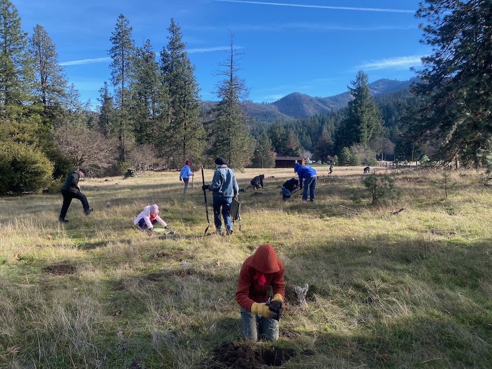
ASA volunteer native planting day at Nick Wright Flat in November 2025.
In 2025 ASA continued our long-standing efforts to restore native pollinator habitat with native plants at Nick Wright Flat, a rare valley bottom Forest Service parcel along the Applegate River. For eight years ASA has worked with the Forest Service planting and seeding native herbaceous plants in a large weedy river terrace adjacent to homes and ranches in the Upper Applegate Valley. The site contains existing native plant habitat with some important and robust native plant populations. ASA has also pulled noxious weeds, like yellow star thistle, to help control invasive plants, and we have been planting containerized native nursery stock and sowing native seeds collected in nearby habitats.
Over time native plant populations have begun taking hold in small self-sustaining populations throughout the large riverside terrace. We hope to continue planting nursery grown native plants, sowing native seeds, and restoring native plants at Nick Wright Flat in 2026.
THANK YOU to all the volunteers that have contributed to this native planting and seeding effort! We can’t do it without you!
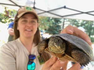
Turtle Tales: Pond Turtle Field Trip & Online Webinar
Wildlife biologist Jade Keehn measuring and identifying individual pond turtles at Acorn Women Lake during our Turtle Tale Field Trip.
ASA held an online webinar and field trip to Acorn Women Lake about Western pond turtles—a declining species and candidate for listing as a threatened species under the Endangered Species Act—with Jade Keehn, wildlife biologist for the Oregon Department of Fish and Wildlife, and Erin Considine, wildlife biologist for the US Forest Service. We walked around Acorn Women Lake, viewed pond turtles, learned about their ecology, and also participated in a long-term monitoring project at the lake, where an estimated 200+ turtles live and are monitored yearly.
Game Camera Wildlife Monitoring
ASA monitors wildlife in the Applegate Siskiyou region using game cameras to document wildlife populations, wildlife movement and wildlife behavior. Below is a series of awesome video clips of a black bear mama and cubs at a local spring and bear wallow. This video has had over 10,000 views on ASA’s facebook page and has been shared widely because it’s pretty amazing footage. Check it out, it might just make your day! We could watch it over and over again.
Building a foundation for future protections
Siskiyou Crest Coalition
ASA is proud to be an active member and fiscal sponsor for the Siskiyou Crest Coalition (SCC), a collaboration of non-profit organizations, businesses, and individuals promoting permanent habitat protections for the Siskiyou Crest region.
A Siskiyou Crest Coalition presentation in Mt. Shasta, California with are partners at the Mt. Shasta Bioregional Ecology Center.
SCC has been working on many foundational projects in 2025, increasing our outreach capacity both in southern Oregon and northern California. We have been making presentations around the region about the wonders of the Siskiyou Crest and have been organizing some exciting projects to explore the science and the biodiversity of the Siskiyou Crest region.
In 2026 SCC will host another Siskiyou Crest Artist in Residence at Acorn Woman Lookout and will sponsor the Siskiyou Crest Moth Project.
ASA led a public wildflower hike to see the fire induced super bloom in the 2024 Upper Applegate Fire footprint. Leading the hike a year later in the spring of 2025 flowers and grasses had colonized the burned soils and stump sprouting shrubs and hardwood trees had already begun their recovery.
Although we visited the area slightly early for the super bloom, the flowers were still great and we did have the pleasure of viewing the rare Gentner’s fritillary in full bloom!
The endangered Gentner’s fritillary blooming in the 2024 Upper Applegate Fire area south of Ruch in spring 2025.
In spring 2025 the Ruch Library hosted a public panel presentation about conservation in the region. Luke Ruediger from ASA was a featured panelist at the presentation.
ASA and the Siskiyou Crest Coalition also made presentations in Mt. Shasta and for the Friends of Ahart Herbarium in Chico, California. We also participated in an EcoNews Report radio interview with Tom Wheeler, Executive Director for northern California’s Environmental Protection & Information Center (EPIC).
ASA pushed back in coalition with conservation groups across the country to oppose the Trump Administration proposals to eliminate the Roadless Rule. The Roadless Rule protects millions of acres nationwide, including large unroaded swaths of intact forest and woodland across the Applegate River drainage and across the Siskiyou Crest.
We also hosted a wonderful presentation with Robert Kentta from the Confederated Tribes of Siletz Indians. Robert’s great-grandfather was born in the Applegate and was orphaned during the Rogue Indian Wars before being forcefully removed on the Oregon “Trail of Tears.” His presentation covered tribal history of the Applegate area. We learned a lot and were both honored and grateful to host Robert and so many of his relatives at this large public presentation at Pacifica Gardens in Williams.
In May 2025 we hosted Robert Kentta for a presentation on Applegate Valley Native American history.
2026: Storms brewing on the horizon
The Applegate Siskiyou is threatened like never before, and more than ever before we need a strong grassroots response. ASA is committed to providing a strong response on behalf of the wildlands in this spectacular, diverse, and regionally important landscape. We know the beauty and the biological value of this incredible region, and we see the storms brewing on the horizon.
Our goal is to weather the coming storm, while maintaining the biodiversity and beauty of the wildlands in the Applegate Siskiyou. We will fight for this region in 2026, defending old forests, intact habitats, wildlife, watersheds, and wildlands, while working to support a vision for the future that protects, respects, restores and rewilds the spectacular Applegate Siskiyou region.
Join us in 2026 and consider a generous year end donation!
Together the SOS Project and the Douglas Fir Mortality Complex combine to create over 13,000+ acres of logging in the Applegate Valley, that could forever scar the hillsides with heavy industrial logging.
The BLM’s latest in a slew of timber sales focused on the Applegate is called the Douglas Fir Mortality Complex Project. And there are even more logging projects on the horizon!
The Medford District BLM has been proposing increasingly large and damaging timber sales in the Applegate Valley, and the region many of us know and love is about to change forever. That is unless we organize and protect our BLM forests!
If the BLM had it their way, they would log off every living, green forest they could get their hands on, and if unchecked the series of timber sales currently proposed would log much of the mature forest remaining on BLM lands in the eastern Applegate Valley.
Currently, the BLM has either sold, or will soon auction off timber sales in portions of Sterling Creek, on the East Applegate Ridge Trail, and on the face of Woodrat Mountain in the Holcomb Hollow Timber Sale, on the eastern face of Ben Johnson Mountain in the Apple Saws Timber Sale, and in the Thompson Creek/Ferris Gulch area in the Thom Bone Timber Sales. Together these timber sales make up large portions of the massive SOS Project which constitutes around 5,000 acres of logging.
Now the BLM has proposed a new and even larger project, the Douglas Fir Mortality Complex Project which proposes to scale this logging up even further and log off vast portions of the Little Applegate Valley and Sterling Creek, as well as portions of the Upper Applegate Valley.
A map of the Douglas Fir Mortality Complex Project logging proposed in the Applegate Valley. Blue polygons are logging units, green are linear logging treatments, red are roadside hazard logging operations, and the re-hash mark is fuel reduction.
In total, 9,000 acres are proposed for logging in the Douglas Fir Mortality Complex Project with the vast majority proposed in the Applegate watershed. This is not only the largest individual timber sale in recent memory on BLM lands in the Applegate Valley, but it will also continue the implementation of the BLM’s so-called “salvage” logging operations, and the most damaging timber sale agenda since the heyday of old-growth logging in our region.
The ridgeline and slope at the center of the photo was “salvage” logged in the Boaz Salvage Timber Sale. This stand was largely green forest before the logging took place and much of the eastern Applegate Valley would be equally denuded, exploited and abused if the Douglas Fir Mortality Complex is implemented.
The impact of these logging projects would be unprecedented and would forever scar the mountains of the Applegate Valley with clearcuts and biologically sterile plantation stands, where mature, complex forests once stood. The result would be widespread deforestation across the Applegate Valley, logging off many large, fire resilient, relatively intact, mature, late successional, and even old-growth forests, as well as mature stands with recent beetle mortality. In total, the BLM is proposing approximately 13,000+ acres of “salvage” logging in the Applegate Valley, which will devastate forests and watersheds across our region.
The logging in “green” stands would permanently lock the door on northern spotted owl recovery across vast swaths of the Applegate River watershed, rendering currently suitable habitat useless to the owl by thoroughly degrading habitat conditions and leaving it unsuitable for many decades to come. The project proposes to create a long-term deficit in late successional stand characteristics by removing nearly all large diameter trees, standing snags, and large downed wood recruitment.
These same structurally simplified conditions would also impact species like the Pacific fisher, Siskiyou Mountains salamander, and great gray owls that nest, den, and/or rear young in the Applegate River watershed. The logging and yarding operations would also spread noxious weeds, damage soils, and degrade local streams and watersheds.
The BLM claims that the Boaz Salvage Timber Sale was not clearcut logging, yet conditions in the Boaz Salvage Timber Sale following logging treatments demonstrates otherwise.
The net result of these logging activities would lead to increased fire risks across the eastern Applegate Valley, threatening communities, lives, and public safety. In stands with living overstory canopy, logging would remove large fire resistant trees and virtually eliminate the moderating effects of canopy. This in turn, would dramatically alter microclimate conditions by transitioning closed, relatively cool, moist habitat conditions with minimal understory growth into hotter, drier, more windy environments that are conducive to fast moving, high severity fires.
Additionally, within 1-5 years these stands would also include far more fine fuels on the forest floor where it is more accessible and volatile during fire events. This is because logging slash left behind during logging operations would mix with the dense, young, regenerating vegetation triggered by the large tree and canopy removal operations proposed throughout the Douglas Fir Mortality Complex Project. This will create an explosive fuel bed across thousands of acres.
According to BLM documentation, creating openings far smaller than the clearcuts proposed during BLM “salvage” operations would increase fire risks in both the short and long term.
“For the first 1 to 5 years after harvest, these stands would remain a slash fuel type until the shrubs, grasses, and planted trees become established. After the establishment of regeneration, these stands would move into a brush fuel type. Brush fuel types are more volatile and are susceptible to high rates of fire caused mortality. Stands could exhibit higher flame lengths, rates of spread, and fire intensity. Fires started within these stands could be difficult to initially attack and control. For 5 to 20 years following planting, the overall fire hazard would increase in these stands.” (BLM Clean Slate Timber Sale EA P. 192)
Following logging, the open, sunbaked slopes affected by the Boaz Salvage Timber Sale will soon grow in with thick, woody regeneration, creating much higher fire risks.
The impacts of the Douglas Fir Mortality Complex Project will only be more severe because the size of the openings would multiply wind speeds and the stand drying effects. The scale of the openings would also increase the scale at which young, even-aged vegetation occurs on the landscape, allowing for more intense fire behavior, faster rates of spread, and fires that are more difficult to contain or control.
Additionally, removing dead standing snags in salvage logging operations creates all the same impacts as green tree logging, if not more, due to the heavy handed logging operations and minimal tree retention in so-called “salvage” logging sales. The plantation-like stands created after “salvage” operations both resemble and operate like clearcuts, while the yarding, logging and hauling operations create significant downstream watershed effects. Snag forest logging releases vast quantities of carbon and degrades wildlife habitats filled with important biological legacies. Snag removal also impacts biological diversity, and simplifies the structural conditions found in regenerating stands.
Both the mainstem of the Applegate River and the Little Applegate River below the logging units contain important steelhead, chinook and coho salmon spawning habitats, and the logging proposed in the BLM’s Douglas Fir Mortality Complex Project, would lead to extensive watershed, fisheries and water quality impacts. In the recent Boaz Salvage Timber Sale seasonal streams were filled in to create skid trails for unauthorized ground-based yarding, Riparian Reserves were logged, and landslides were triggered by clearcut “salvage” logging in previously living, green stands. These landslides led to debris flows that filled streams with thick mud and logging slash, and continue to do so each time it rains.
Finally, if implemented, the logging proposed would further degrade the viewsheds of the Applegate Valley, turning one of Oregon’s most beautiful valleys and one of the region’s most unique habitats into a vast expanse of clearcuts. Recent BLM “salvage” sales have logged tens of thousands of large, mature, living trees while retaining as little as 0.9 trees per acre in some units, and as little as 4.6 trees per acre on average across entire timber sales.
Nearly every forested habitat on the western face of Boaz Mountain in the Upper Applegate Valley would be logged in the Douglas Fir Mortality Complex Project, leaving the slope bare, disturbed and dominated by stumpfields.
What does this mean for the Applegate Valley?
It means we get to live with the impacts of BLM logging everyday. It means incredible harm to the community and to our environment for generations to come. It means habitat destruction, stream sedimentation, impacts to fisheries, damage to scenic qualities, and irreplaceable harm to outdoor recreational opportunities.
For residents of the Applegate, it means losing some of what we love, as we transition from living in a beautiful, relatively intact natural environment, to an industrialized, freshly damaged landscape filled with sunbaked slopes, noxious weeds, non-native grasses, dense young growth, denuded forests, extensive stump fields, new roadbeds, log landings, the deep vertical scars of skyline yarding systems on steep slopes, and dramatically increased fire risks.
These forests above Griffin Lane would be heavily logged in the Douglas Fir Mortality Complex Project. Increasing fire risks near communities and homes in the Applegate Valley, while damaging the beautiful natural setting residents call home.
For businesses owners in the Applegate, it means damage to the viewshed surrounding your tasting rooms, vineyards, farms, bed and breakfast, vacation rentals, restaurants, farm stands, and cottage industries. It means damage to the scenic qualities for visitors and residents alike, as they drive through our region, hike or mountain bike our local trails, camp in local forests, and participate in our local economy. We all know it is the beauty of the Applegate Valley and the nearby public lands that bring residents and businesses to our region, and also keeps visitors coming back.
The BLM has proposed to wipe out the forests of the Applegate Valley as obedient servants of the Trump Administration. Claiming to be logging only “dead and dying” trees, the BLM has, in fact, been mowing down living, green forests in the Applegate River watershed for the past two years, logging off the very trees and stands of trees that survived the recent beetle mortality outbreaks.
A view from the Tunnel Ridge Trail demonstrates that significant green forest remains in refugia habitat on Trillium Mountain. These uncut forests are located in the driest watershed in western Oregon and maintained moderate levels of beetle mortality in recent years. Yet, significant mature forest still exists on less exposed north-facing slopes, in the interior of stands, and in topographical features that reduce solar exposure and promote more robust conifer growth. The Douglas Fir Mortality Complex has declared every forested habitat on the north slope of Trillum Mountain “dead and dying” and has proposed every conifer “stringer” on the mountain for heavy industrial logging. This will devastate the local ecology and damage the viewshed of the Sterling Mine Ditch Trail system.
The future of the Applegate hangs in the balance and it will take significant community-based activism and advocacy to protect our backyards. Please comment on the Douglas Fir Mortality Complex and let the BLM know how you feel about turning the beautiful Applegate Valley into an ugly, biologically sterile stump field, with enormously elevated fire risks.
Slopes like these above the Salant Ranch in the Little Applegate Valley near Buncom contain a mixture of dead standing trees and living, green forest. These stands could be virtually clearcut as slopes have been in recent “salvage” logging timber sales implemented by the Medford District BLM. Currently the vast majority of this slope is proposed for commercial logging in the Douglas Fir Mortality Complex.
Talking Points For Your Public Comment
The BLM is targeting extensive stands of living, viable, green forest with no sign of significant beetle mortality or infestation and is implementing clearcut salvage logging. Many of these forests are located in refugia habitats, including canyon bottoms, north-facing slopes, east-facing slopes, areas with deep soils, and in stand interiors where forest conditions moderate the impact of drought, heat, and beetle mortality events. These stands should be retained.
Snags and downed wood are important habitat components necessary for forest development, vegetative regeneration, and resilience. They are also some of the most important wildlife habitats in our forested landscapes and should be retained to the largest extent possible on the landscape.
No living trees should be removed, and only dead standing hazard trees within 100′ of regularly used BLM roads should be considered for removal. This action alone would meet public safety objectives, while maintaining more biological diversity, habitat resilience, and effective stand regeneration.
The logging proposed in the Douglas Fir Mortality Complex Project would damage important habitat for the threatened northern spotted owl, the Siskiyou Mountains salamander, the Pacific fisher, great gray owls, and numerous native fisheries, including the threatened coho salmon in the planning area or areas downstream of the project area.
The logging proposed in the Douglas Fir Mortality Complex would badly damage scenic qualities, local communities, viewsheds, and outdoor recreational activities, including Recreation Management Areas, forests along popular trails, in the viewshed of popular trails, in proposed trails systems associated with the Siskiyou Skyline Trail system, and within view of communities, residential properties, businesses, wineries, vineyards, tasting rooms, vacation rentals, event centers, etc., that thrive on the area’s scenic qualities and intact viewsheds. These would be profoundly negative impacts to this community and to recreational values in the area.
The cumulative impacts associated with “salvage” logging in recent years have created enormous impacts not analyzed or authorized in the BLM’s 2016 Resource Management Plan. These impacts include dramatically increased fire risks, damage to important wildlife habitats, the degradation of water quality, stream habitats, water supplies, recreation opportunities and experiences, and scenic qualities. These cumulative impacts should also preclude the agency from further “salvage” activities due to already severe affects in the Applegate River basin.
“Salvage” logging has no scientifically valid benefits and causes significant harm to the environment by removing biological legacies, starving future stands of snags, large living trees and large downed wood recruitment.
Removing snags and living trees in areas affected by natural disturbances, like beetle outbreaks, is damaging to wildife, watersheds, outdoor recreation, local communities, natural environments, and increases fire risks by generating even-aged young, highly flammable vegetation and increased logging slash with little stand complexity, heterogeneity, or biological diversity.
The results of “salvage” logging proposed in the Douglas Fir Mortality Complex Project will be the creation of widespread “regeneration” harvest, or clearcut logging units in dry forest habitats where these practices are not allowed in the BLM’s 2016 Resource Management Plan.
Ask the BLM to cancel the Douglas Fir Mortality Complex Project and work with communities on real fire risk reduction adjacent to rural communities.
Submit comments at the BLM eplanning website by following this link and clicking on “participate now”
A Flurry of BLM Timber Sales in the Applegate Valley
It has become customary in the Applegate Valley for the BLM to spoil our holiday season by putting out timber sales just before and during the holidays. This year is no exception, as the BLM has approved a series of timber sales that threaten the forests surrounding our homes and communities, including the BLM’s latest, the Thom Bone Timber Sale, that is slated to be auctioned off on December 18th.
Authorized on September 25, 2025 under the larger Ashland 2025 Strategic Operations for Safety (SOS) Environmental Assessment (EA), the Medford District BLM initially auctioned off three timber sales as part of the larger SOS Project, centered around Sterling Creek, Woodrat Mountain, Ben Johnson Mountain, along the East Applegate Ridge Trail, and in the Wellington Wildlands at the headwaters of China Gulch just one month later.
Unit 13-2 of the Holcomb Hollow Timber Sale lies directly adjacent to the East Applegate Ridge Trail and would log all trees in this photo, except the two marked with yellow paint.
Two of these timber sales sold to the highest bidder, including the Apple Saws Timber Sale above Cantrall Buckley Park and on the face of Ben Johnson Mountain, which sold to Estremado Logging from Gold Hill, and the Holcomb Hollow Timber Sale on Woodrat Mountain and Sterling Creek, as well as along the beloved East Applegate Ridge Trail. The Holcomb Hollow Timber Sale sold to local loggers, Parker Excavation and Forestry, and together these timber sales will be impacting the forests, fire safety and viewsheds of the Ruch and Sterling Creek areas, and along the extremely popular East Applegate Ridge Trail.
As if that was not enough, on November 18, 2025 the BLM announced the approval of the Thom Bone Timber Sale, and almost immediately put this timber sale up for auction to the BLM’s timber industry partners, announcing an auction coming up on December 18, 2025.
Thom Bone Timber Sale
Watch ASA’s video about the Thom Bone Timber Sale, just click on the video above.
The Thom Bone Timber Sale consists of 530 acres of logging treatments, including 284 acres of “unit” or area “salvage” treatments and 246 acres of “linear” treatments along ridges and roads in the Thompson Creek watershed. Creating an estimated 8.9 million board feet of timber, and removing trees that have an average of 18.1″ diameter at breast height, the logging proposed in the Thom Bone Timber Sale is neither focused on dead and dying trees or small diameter fire prone trees as the BLM has previously suggested. In fact, the BLM would log 24,083 trees, while retaining only 5,139 trees, the equivalent of only 9.7 trees per acre.
Trees left unmarked by BLM marking crews are identified for logging in the Thom Bone Timber Sale, including these large, old trees over 30″ diameter. Clearly holding up the steep mountain slope in unit 17-1, this tree, as well as the vast majority of the trees in this stand, are living, green trees with no sign of beetle infestation or imminent death or “decline.” In this unit BLM’s narrative is simply false and misleading—the trees are not dead and dying and the stand will not benefit in any way from the logging proposed.
The Thom Bone Timber Sale, just like the Apple Saws and Holcomb Hollow Timber Sales, proposes logging in a variety of habitats, including both stands with significant levels of beetle induced mortality and stands of living, green forests that demonstrated resilience and vigor, by surviving recent beetle mortality events.
The project calls for logging stands with as little as 10% mortality, meaning they could log forested stands where 9 out of 10 trees survived the recent droughts and beetle mortality events. The BLM wants to log the resilient survivors.
Closed canopy stand conditions and very little recent tree mortality characterize unit 29-1 of the Thom Bone Timber Sale. Although the BLM claims this and many other stands are “dead and dying,” this stand and many other in this project are, in fact, very much alive.
According to the BLM’s Thom Bone Timber Sale Prospectus, the agency also intends to log off 82.5% of the existing trees in the timber sale. The result would be to create far more mortality through logging than the previous beetle mortality events, leaving only a few scattered trees where a forest once stood.
Although the BLM claims in the Ashland 2025 SOS EA that the Thom Bone Timber Sale is removing only dead and dying trees, the Timber Appraisal Summary used to described the project to potential timber industry purchasers specifically lists all volume as “green” tree logging, rather than a “salvage” harvest. This same document also discloses that all 530 acres proposed for logging are being characterized as “regeneration” harvest units, meaning the existing overstory trees will be largely removed, triggering a new “cohort” or generation of young, highly flammable vegetation.
Increased Fire Risks
By removing these large trees and mature closed forest canopies with relatively cool, moist stand conditions, and replacing them with the hotter, drier conditions characteristic of BLM logging units, fire risks will dramatically increase. This transition will create higher surface temperatures, higher surface wind speeds, drier fuels, and significantly more dense, young, even-aged, and highly flammable vegetation, mixed with the logging slash of the BLM logging units.
A large, living fire resistant tree (36″ DBH) left unmarked and thus identified for logging in unit 17-1 of the Thom Bone Timber Sale on upper Thompson Creek.
According to BLM’s own analysis in previous timber sales, this transition from closed forest to early seral post-logging vegetation represents an increase in fire risks for extended periods of time. “For the first 1 to 5 years after harvest, these stands would remain a slash fuel type until the shrubs, grasses, and planted trees become established. After the establishment of regeneration, these stands would move into a brush fuel type. Brush fuel types are more volatile and are susceptible to high rates of fire-caused mortality. Stands could exhibit higher flame lengths, rates of spread, and fire intensity. Fires started within these stands could be difficult to initially attack and control. For 5 to 20 years following planting, the overall fire hazard would increase in these stands.”
Although we believe this description above significantly underestimates the amount of time these logging treatments will increase fire risks, the influence on severity, spread and resistance to control has been confirmed in numerous scientific studies conducted across the West. Regeneration or clearcut logging, as proposed by the BLM in the SOS Project has many impacts, including a dramatic increase in fire risks.
The Impact of Salvage Logging
Although large portions of these timber sales are living, green stands that survived recent drought and beetle mortality events, in other locations stands with significant tree mortality are also being targeted for logging. This would remove what scientists call biological legacies, including snags and future downed logs that are important in building forest complexity and maintaining late successional habitat conditions on both the individual stand and landscape scale.
The aftermath of the Boaz Salvage Timber Sale logged last winter on BLM land above Eastside Road in the Upper Applegate Valley. The clearcut slopes slid out during heavy rains creating a debris flow of mud and logging slash that filled the stream bed below in mud and fine sediment.
These stands are more than just dead trees, they are habitat for innumerable species, they play a significant and important role in maintaining biodiversity, they store carbon, add structure to regenerating forests, and fall to the forest floor adding carbon to forest soils, retaining moisture on the landscape, stabilizing slopes, enhancing stream habitats, and supporting mycorrhizal associations necessary for the regeneration of conifer forests. Following logging operations all these values will be impacted and the biological legacies they depend upon will be diminished for decades to come.
Residual hardwoods and unaffected conifers within these stands also support heterogeneity, biodiversity and genetic resistance to drought and beetle mortality; however many of these same trees are proposed for logging in the BLM’s salvage timber sales. Hardwoods and non-target species like madrone, black oak, white oak, or live oak are often damaged beyond repair during logging, tree felling, and skyline yarding operations.
No matter the disturbance agent, the salvage logging of natural processes like wildfires and beetle mortality events has profoundly negative consequences for wildlife, for future wildfire behavior and effects, for soils, for watersheds, for the maintenance of biodiversity, and for the regeneration of forest habitats in wake of these natural disturbance agents. Mortality is part of the natural process; it produces biological legacies and biodiversity, and sustains numerous vital biological inputs to soils, streams, wildlife habitats and forest complexity that provide benefits for hundreds of years into the future. However, these same trees and snags are being logged for short-term industry profits and to satisfy BLM’s insatiable appetite for public land timber sales.
Impacts to Late Successional Reserve habitats
Ironically, the Thom Bone Timber Sale is located in a large block of Late Successional Reserve (LSR) forest habitat, where forests were set aside for the development of old forest characteristics and Northern spotted owl habitat. Because of this focus, both “salvage” logging and “regeneration” harvest are prohibited outside rather narrow exemptions surrounding public safety.
The timber sale mark in unit 17-1 of the Thom Bone Timber Sale is marked red for retention, meaning only trees marked red would remain following logging operations. In this photograph only two mature trees would be retained and the currently closed stands of living, mid- to late-successional forest with large, relatively fire resistant trees, and enough canopy to suppress understory growth would be heavily impacted. Late Successional Reserves were designated to enhance, develop and maintain old forest conditions, yet as you can see in the photograph, the BLM calls for removing most of the older trees in this stand.
Regeneration logging and “salvage” logging as proposed in these timber sales will preclude the development of late successional forest habitat characteristics for more than 20 years, and the heavy handed LSR logging units proposed in both the Apple Saws and Thom Bone Timber Sales are direct violations of the BLM’s 2016 Resource Management Plan. These treatments have more to do with the BLM’s unending desire to increase timber production, than the maintenance, enhancement and long-term recruitment of mature and old forest habitats as the LSR designation intends.
Economic and Scenic Impacts
Unit 17-1 of the Thom Bone Timber Sale is beautiful mature forest rising out of the Applegate Valley on upper Thompson Creek. The area highlighted in yellow has been declared “dead and dying” by the BLM, but supports living, green forest with very little recent tree mortality.
It is the beauty of this place that defines it, and in turn supports our local economy. Local residents are filled with pride and dedication to this spectacular place, while visitors are often blown away by the diversity of the landscape, its stunning scenery, and its wide variety of outdoor recreational opportunities.
Known for its hiking, mountain biking, and wineries, the area is also great for backpacking, boating, camping, swimming, paragliding, trail running, botanizing, bird watching, recreational backcountry driving,and other outdoor activities.
The Applegate’s spectacular quality of life is directly tied to the environment of the surrounding public lands and the recreational opportunities that attract visitors, residents and small businesses that support the community and local economy, which often depend on an intact natural environment in the region to thrive. For example, public lands and public streams keep cold water pouring into the Applegate River during the summer months, and contribute irrigation for our local farms, vineyards, ranches and homesteads. Additionally, the beautiful, largely unspoiled scenery attracts hikers, mountain bikers, wine aficionados, residents, tourists and others to our region.
The timber sales currently proposed by the BLM would damage scenic values throughout large portions of the Applegate Valley, spoiling the area’s spectacular viewshed, unique natural beauty, intact environments, and outdoor recreational activities. BLM lands surround many of the homes, vineyards, farms, ranches and communities here in the Applegate and people often come to the region specifically to enjoy the scenery it provides and the natural beauty of the place.
The famous valley views of Ruch will be badly impacted by heavy industrial logging on Ben Johnson Mountain in the Apple Saws Timber Sale (circled above in red), and on the western face of Woodrat Mountain in the Holcomb Hollow Timber Sale.
Imagine the mountains of Sterling Creek, above Cantrall Buckley Park, on Woodrat Mountain, and Ben Johnson Mountain, along the East Applegate Ridge Trail, and all around Ruch scarred with clearcuts, stripped of greenery, and converted into regenerating stump fields. That is the impact of BLM “salvage” logging in our valley and the cumulative impact of the SOS Project.
Together the Thom Bone, Apple Saws, and Holcomb Hollow Timber Sales would leave the lasting scars of logging and greed across the mountains of the Applegate, degrading viewsheds, damaging habitats, impacting water quality in nearby streams, spreading non-native and noxious weed species, and threatening many of our neighbors with significantly increased fire risks adjacent to homes in the Applegate Valley. The Trump Administration has promised an increase in logging on federal lands, and in the Applegate Valley, this is what that increase looks like: barren slopes, landslides, increased fire risks and significant impacts to the scenic character of our landscape.
Please help Applegate Siskiyou Alliance oppose the SOS Project and the numerous timber sales the BLM has approved under it.
1) Make a donation
Donate to ASA to support our work challenging these timber sales, and our work to SAVE APPLEGATE FORESTS!
Help us organize our community against increased BLM logging, and work with us to oppose the renewed push for clearcut logging across the Applegate Valley in the SOS Project.
Demand that the Holcomb Hollow, Apple Saws, Chopper Styx and Thom Bone Timber Sales be withdrawn due to unacceptable impacts to wildlife, to Late Successional Reserve forests, to Riparian Reserves, to the spectacular East Applegate Ridge Trail and Wellington Wildlands areas, and to our community’s fire safety. Both the logging of mature, living stands and the logging of dead standing trees will degrade habitat values, encourage young, highly flammable tree and shrub development, increase fire risks, damage scenic values and impact our community and economy.
Medford District Field Manager, Elizabeth Burghard: eburghar@blm.gov
6) Go out and see the timber sales for yourself.
-Drive the Cantrall and Ben Johnson BLM access roads above Cantrall Buckley Park. The paved road will lead through numerous proposed logging units in the living, green forest on BLM lands.
-Walk the East Applegate Ridge Trail. From the upper trailhead walk about halfway out the trail to the rock outcrops overlooking Ruch. Shortly after entering the trees you will walk through proposed logging units. Additional units are located on the slopes across from the trail as you drop down into Highway 238, and on the north slope of the ridge on the upper portion of the lower road segment. Units are mostly living stands with some patches of recent beetle mortality.
-Drive the Woodrat Mountain access road west from the summit on Sterling Creek Road. You will enter proposed logging units as soon as you reach BLM lands. These units are living, green forests adjacent to rural residential property on Sterling Creek Road.
-Drive up the west face of Woodrat Mountain by turning east off Highway 238 on Bishop Creek Road. Turn right onto the Squires Peak Road leading to the lower Woodrat Mountain Paragliding sites. This road will pass through units with significant mortality. Turn right onto road 38-2-23.1 and follow it through proposed units with a mixture of dead standing snags and living, green trees.
Watch this video to see the tragic results of the BLM’s Boaz Timber Sale.
The Medford District BLM approved and sold the Boaz Salvage Timber Sale in the Applegate Valley in southwest Oregon in 2024. The Mineral Creek Logging company logged the timber sale throughout 2024 and 2025 with devastating effects to the forests, water quality, wildlife habitat, and fire resistance of the area. Beautiful, green, living forests in the Upper Applegate and Little Applegate watersheds were logged, and many of them were clearcut.
High priority habitat for the endemic Siskiyou Mountains salamander was logged, where salamanders have been documented to live. Logged trees were dragged along the ground in long yarding corridors that created scars across the landscape that greatly damaged Siskiyou Mountains salamander habitat, hydrology and native plant habitat.
Seasonal streams were filled in with sediment and used as logging corridors. A massive landslide was triggered by wet weather clearcut logging, filling in the stream channel with mud and debris.
Huge amounts of logging slash have been left throughout the area, greatly increasing fuel loads in the area and putting the homes below at increased risk of wildfire.
The massive amounts of ground disturbance have already increased the amount of invasive and noxious weeds in the area, degrading pollinator habitat by displacing native plants with non-native plants.
Habitat for northern spotted owls and Pacific fisher in the area has been negatively impacted. Logging scars are now visible from many areas of the Upper Applegate and Little Applegate, marring the beauty of the valley that relies on recreation and tourism for economic vitality.
The rural, Applegate-based conservation organization, Applegate Siskiyou Alliance (ASA), was one of the only environmental organizations to fight this egregious timber sale, but were unsuccessful in the battle to save these important Applegate forests. At the same time, the fight continues as the BLM has sold more timber sales under its current SOS Project, and ASA hopes to succeed in stopping some of these new timber sales. We need your support to SAVE APPLEGATE FORESTS.
Donate to Applegate Siskiyou Alliance today by clicking on the button below.
Rising above the Ruch area, the view across the Applegate Valley to Ben Johnson Mountain is one of the most iconic and cherished in the region; however, BLM has identified a series of logging units in the mature, living forest, circled in red in the photo above. Claiming the area is “dead and dying” the agency has proposed logging 82% of the trees in units spread all across Ben Johnson Mountain’s scenic eastern face.
Closed to the public but open to the highest timber industry bidder
On September 25, 2025 the local BLM sunk to a new low in transparency and accountability by shutting the public and the media out of its public land timber sale auction in Medford, Oregon. Facing threats of arrest, public members and the media were barred from entry, while the agency sold our public forests behind closed doors.
Taking their cues from the Trump Administration, the Medford District BLM is seizing its opportunity to log off our public forest lands with little to no public accountability, and they are doing so behind locked doors, guarded by armed federal law enforcement. In this way, our local BLM is closed to the public, but open to the highest bidder during timber sale auctions.
The outcome of this closed-door timber sale auction included the sale of two major Applegate Valley timber sales to the timber industry. These two Applegate timber sales are the first in a series of timber sales being proposed under BLM’s controversial SOS Project, which plans to log over 5,000 acres across the Applegate Valley, from Thompson Creek to Ruch, and east to Sterling Creek.
The Applegate Valley timber sales offered for auction included:
The Apple Saws Timber Sale above Cantrall-Buckley Park and on the eastern face of Ben Johnson Mountain.
The Holcomb Hollow Timber Sale surrounding Ruch and Sterling Creek, including units along and in the immediate viewshed of the popular East Applegate Ridge Trail, on the face of Woodrat Mountain, and in the mountains surrounding homes and communities in the Sterling Creek watershed.
The Chopper Styx Timber Sale in the Wellington Wildands and throughout the headwaters of China Gulch above Ruch.
Of these three timber sales, both the Apple Saws and Holcomb Hollow Timber Sales sold to private logging companies, while the Chopper Styx Timber Sale, which relied on helicopter yarding to access the timber, received no bids. So, in the immediate future, the BLM hopes to begin implementing the Apple Saws and Holcomb Hollow Timber Sales, riddling our beloved Ruch and Little Applegate Valley with fresh logging scars.
Conditions in unit 5-6 of the Apple Saws Timber Sale include relatively open-spaced groves of closed canopy mixed conifer forest. Dominated by large trees and supporting very little recent mortality, these stands are important mature forest habitat. They are also located in Late Successional Reserve forest designated to protect habitat for the northern spotted owl. Many. of the units proposed for logging appear to contain both dispersal and nesting, roosting, foraging habitat, such as this stand featured in the photo above. Following logging operations only two trees marked with white paint in this photograph would be retained.
The impact will be to degrade recreational experiences on the extremely popular East Applegate Ridge Trail, as well as the adjacent Woodrat Mountain Launch Sites, where world-class paragliding competitions occur. The SOS Project, just like the previous “salvage” timber sales implemented in the Applegate Valley, will be damaging to scenic and aesthetic values adjacent to these recreational opportunities, and surrounding our homes, wineries, farms, and communities in the eastern Applegate Valley
Additionally, the BLM has already listed additional SOS “salvage” timber sales in their 2026 Timber Sale Plan, including large portions of Thompson Creek. Together, this series of timber sales proposed by the BLM under the SOS Project would combine to create one of the largest BLM timber grabs in the Applegate Valley for numerous decades.
Orwellian doublespeak, episodic beetle outbreaks, and predicted tree mortality
Using their typical Orwellian doublespeak, BLM is working to convince the public that living, green trees and forests must be logged, paradoxically to save them from future mortality. The project claims to be targeting “dead and dying” trees, but its broad interpretation of “dying” allows for the removal of whole stands of living, viable, green trees that survived recent beetle mortality outbreaks and expressed natural resilience under significant biological stress.
The droughts that trigger these beetle outbreaks are obviously cyclical and even under the current climate scenario, they come and go in southwest Oregon. Beetle mortality events often mirror those drought events and are considered “episodic,” meaning beetle populations often expand in direct response to the stress created by drought events, heat domes, and what some scientists are calling “hot droughts.” Under conditions of low precipitation and uncharacteristically warm temperatures—including both extended periods without sufficient winter cold and periods of extreme summer heat–beetle populations attack damaged or stressed trees en masse, build large populations, and create high levels of susceptible tree mortality. Yet, when the drought and heat subside, the beetle populations collapse and these habitats reestablish more characteristic levels of tree mortality.
The conifer forest in this photograph shows conditions in unit 13-1 of the Holcomb Hollow Timber Sale. Directly visible from the East Applegate Ridge Trail, this living conifer forest would be heavily logged. On average across the entire timber sale area, 73% of the existing trees are proposed for logging. You can imagine the impact of logging 73% of the trees in this stand and how little would be left other than stumps and logging slash.
The past few winters have seen a return to characteristic levels of precipitation, along with the return of more normal temperatures, and the lack of heat dome events in the region. This has dramatically reduced tree mortality across the landscape. In fact, the data collected by federal entomologists using aerial surveys and imagery, demonstrates that tree mortality in 2024 and 2025 is far less severe than in previous years and has returned to more natural background levels.
Yet when confronted with this information, BLM just moved the goal post in their Environmental Assessment, claiming: “seasonal and annual weather is variable and difficult to predict, prediction of short term (3- 5 year) mortality can be challenging, however, short-term fluctuations should not distract from the long-term trends. The mortality patterns are consistent with projected changes in suitable habitat, due to climate change (Bennet et al. 2023a). Bennett et al. 2023 discusses continued Douglas-fir mortality and modeled the mortality across highly susceptible areas out to 2055. There is an expectation of a large increase in areas considered marginal for Douglas-fir suitability by 2055 (i.e. Douglas-fir mortality would continue to intensify and expand).”
What this means is BLM could not justify their prediction of short-term mortality (3-5 years) or the idea of logging living, viable mature trees, so they just moved the goal post, expanded their definition of dead and dying, and extended the potential period of predicted mortality out to 2055.
This allows for very broad interpretation of “dead and dying” that could functionally include just about any tree on the landscape BLM chooses to log. Yet this analysis also looses all potential accuracy and credibility by predicting which trees might die in the next 30 years, which is between six and ten times longer than the 3-5 years identified in the 2016 RMP. BLM admits in their quote above that even these more short term, 3-5 year predictions are “challenging,” yet they still claim to be able to accurately predict which trees will die by 2055.
Sound absurd? It is.
Not only does the agency have no evidence or even methodology to identify such long-term mortality trends, but making these predictions is wildly inaccurate and requires logging seemingly viable, green trees today based on an unscientific and unproven theory that these trees will die potentially numerous decades in the future.
Stand conditions in unit 29-7 of the Holcomb Hollow Timber Sale are already quite open, with a high living canopy, minimal understory growth, minimal fire risk, and minimal recent tree mortality. The Holcomb Hollow Timber Sale would log all but a few of the largest trees in this stand, leaving a few trees where this forest once stood. As you can tell from the stumps, this forest has already been commercially thinned/logged.
Recent history and the actual project proposal demonstrates that the BLM will be removing thousands and thousands of living, green trees across over 5,000 acres in the SOS Project.According to the BLM’s Environmental Assessment for the SOS Project, stands considered “dead and dying” may contain as little as 10% mortality, meaning 9 out of 10 trees may have survived the recent hot drought and beetle mortality events, but they will be “salvage” logged anyway.
One of the many problems with this approach is that many of the stands targeted for logging are, in fact, relatively resilient, often mature forests that would be logged to as low as 5% canopy cover. This would leave only a few scattered trees where living, viable forest once stood. Not only is it ridiculous to claim this dramatic increase in cumulative tree mortality will reduce tree mortality in the future, but some of these stands are currently suitable northern spotted owl habitat acting as dispersal or nesting, roosting, foraging habitat for this endangered forest-loving species.
Additionally, some logging units are Siskiyou Mountains salamander sites, while others provide thermal cover for deer and elk, resting and denning habitat for the Pacific fisher, and habitat for great grey owl populations that occupy low elevation mixed conifer and woodlands habitats in the Applegate Valley and on the eastern face of Ben Johnson Mountain.
The impacts of salvage logging on wildlife, wildlands, and fire risks
Previously implemented, BLM “salvage” logging in the Applegate Valley, including the Lower Sterling, Lickety Split, Boaz Salvage and Forest Creek Salvage Timber Sales have demonstrated that many thousands of living, green, viable trees are routinely removed as “dead and dying” trees. The result of this logging on the ground, has in many circumstances, been the removal of nearly all mature overstory trees, a near total loss of canopy cover, the retention of only a handful of trees per acre, large landslides, stream-choking debris flows, excessive stream sedimentation, the removal of northern spotted owl habitat, and the removal of Siskiyou Mountains salamander habitat, including High Priority Sites protected under the Siskiyou Mountains Salamander Conservation Agreement.
In the coming years, these heavily logged slopes will undergo a dramatic transformation and this transformation or habitat type conversion would include a significant increase in fine fuels, young tree and shrub density, and a large increase in overall fire risks due to the increasingly hot, dry, and windy environmental conditions, and the subsequent regeneration of dense, young, highly flammable tree and shrub growth wherever canopy removal and significant BLM logging occurs.
This slope was logged by the BLM in the Little Applegate River watershed in the 2023 Lickety Split Salvage Timber Sale and BLM claims it was not clearcut. Ironically, it looks like a clearcut, acts like a clearcut, will regenerate into a young, even-aged thicket like a clearcut, and will increase fire risks for surrounding communities, like a clearcut. Unit 5-8 of the Apple Saws Timber Sale is a mature mixed conifer forest dominated by relatively large, old trees. It was thinned to about 40% canopy cover by BLM in the 1990s and that canopy reduction led to a significant increase in understory regeneration and fuel loading. The understory growth triggered by the logging in the 1990s has grown thick and conditions will only grow thicker, more fire prone, more even-aged, more plantation-like, and more explosive if more canopy reduction occurs. Additionally, large old, relatively fire resistant trees not marked with white paint would be removed, like the large Douglas fir on the right hand side of this photograph.
In southwest Oregon, it is undeniable that the removal of overstory canopy leads to increased fine fuel development and the regeneration of dense, young tree and shrub growth. This in turn, dramatically increases potential fire intensity, rate of spread and resistance to control. Trading mature stands, even with some level of tree mortality within them, for dense, young, even-aged growth triggered by the logging of living, green trees and forest canopy will not reduce fire risks, and is not a viable solution. Instead, it will set these habitats up for perpetually high fire risks, due to a lack of overstory forest canopy.
In our region forest canopy reduces windspeeds, reduces solar exposure, retains moisture, moderates understory growth, and maintains fire resilience. Removing large trees that are likely to survive all but the most severe wildfires, and reducing canopy cover, only replaces these currently relatively resilient conditions with young, low statured trees that support very little if any natural fire resistance.
The two timber sales currently sold by BLM, and most immediately threatening our beloved valley are explored in more detail below.
Apple Saws Timber Sale
Unit 5-10 of the Apple Saws Timber Sale above Cantrall-Buckley Park contains relatively open stands of mature mixed conifer forest and a living, green canopy dominated by old Douglas fir trees. The unit is marked white for retention, meaning trees like these unmarked open-grown fir would be removed. You can see that conditions are already quite open, hardwood groves are well developed, fuel loading is minimal, the canopy base layer is extremely high and the stand contains neither a significant fire risk nor sustained recent beetle mortality. Yet, the majority of large trees would be removed, like the two large, open-grown trees at the center of this photo, which are unmarked and therefore would be logged in the Apple Saws Timber Sale.
Located above Cantrall Buckley County Park and the eastern face of Ben Johnson Mountain, the mature forests and mountains of the area create the skyline for Ruch and the surrounding valley. Sheltered from the intense late afternoon heat, these east-facing slopes support some of the most persistent and resilient forests in the Ruch area. The project includes predominantly living, green, viable stands of mature forest proposed for heavy industrial logging and significant overstory canopy removal.
The Apple Saws Timber Sale consists of 627 acres in 24 separate units, and is estimated to log 6.5 million board feet of timber. Of the 627 acres targeted for logging, 420 acres (67%) have been marked for tree removal in 19 “area units.” The BLM’s Apple Saws Timber Sale Prospectus notes that in these 19 units, 8,679 trees have been marked with white paint for retention. This accounts for the retention of 21 trees per acre and minimal canopy cover retention. In fact, the same document identified an estimated 40,437 trees for removal, with the removal of 96 trees per acre proposed. This means that across the timber sale area almost 4.6 times as many trees are proposed for removal as are identified for retention.
It also means that currently 117 trees per acre occupy these sites, and approximately 82% of the existing trees would be removed if implemented. So next time you enjoy the view from Ruch, Oregon, from Long Sword Vineyard, Valley View Vineyard, or from highway 238 as you drive through the Applegate Valley, image 82% of the forest removed and only scattered trees standing where currently mature forests exist on the skyline above Cantrall Buckley Park and on the eastern face of Ben Johnson Mountain.
Unit 5-6 of the Apple Saws Timber Sale is a mature mixed conifer forest on the eastern face of Ben Johnson Mountain. Only trees marked with white paint would be retained, meaning the over 30″ diameter Douglas fir in the foreground and numerous others in this photograph would be logged
According to the Environmental Assessment for the entire SOS project, 67% of the forest proposed for logging, approximately 3,000 acres, currently maintains a green, living tree canopy with between 40%-90% canopy cover. This demonstrates that over 2/3 of the proposed logging area is currently in a forested condition and that number is likely even higher in the Apple Saws Timber Sale, where most stands include living, green, viable forests with significant existing canopy cover, and important closed forest habitat values.
The Apple Saw Timber Sale, like much of the SOS Project is green tree logging masquerading as a “salvage” sale, and the vast majority of the Apple Saws Timber Sale is focused on logging in stands with minimal recent beetle mortality and low to moderate fire risks. Yet, the logging proposed will impact habitat values, while increasing fire risks, and creating much higher levels of cumulative tree mortality than currently exist on this landscape. The Apple Saws Timber Sale in particular, is not about mitigating safety hazards, fire risks or beetle mortality on the landscape, it is about producing board footage for the timber industry by exploiting the natural concern of local residents when tree mortality spiked a few years ago.
The BLM is also acknowledging in the Environmental Assessment for this project that after the heavy industrial logging proposed, many of these units will not regenerate into conifer forests, will no longer have the productivity to support forested habitats, and will be withdrawn from the timber harvest land base because a sustainable harvest is unlikely in the future. These impacts cannot be characterized as anything but deforestation, forest destruction, and unsustainable logging. It also creates what scientists call “type conversion,” and it will dramatically increase fire risks in affected stands. Type conversion has long-been been identified as a negative attribute of anthropogenic management, and it occurs when an existing habitat or ecosystem is so badly degraded that it is fully “converted” into a novel system, with no historic analog.
The mature forests on the eastern face of Ben Johnson Mountain would be heavily logged in the Apple Saws Timber Sale, including the vast majority of trees in this photograph. Many of the trees proposed for logging in unit 5-6 and other units across the face of Ben Johnson Mountain exceed 30″ diameter and are living, green trees with healthy canopies.
The type conversion proposed in the SOS Project consists of degrading currently forested, partially forested, woodland or early seral mixed conifer forest habitats into much hotter, drier, more windy habitats filled with stump sprouting, even-aged hardwoods, chaparral, and/or non-native annual grasslands. According to BLM documents in the Clean Slate, Griffin Halfmoon and Poor Windy Timber Sales, this conversion from a forested habitat to a shrub or brush fuel profile represents a significant increase in fire risks, including increased rates of spread, increased resistance to control by fire suppression crews, and increased fire severity in future fire events.
Ironically, many of these habitats directly surround rural residential communities in the Ruch and Sterling Creek areas, where communities will be directly threatened by heavy industrial logging and long-term type conversions that will increase fire risks, reduce the effectiveness of future suppression actions, and encourage the type of fast-moving wildfires that most threaten homes, infrastructure, and community safety.
The Apple Saws Timber Sale will devastate our viewsheds, degrade our forests, threaten our communities with increased fire risks, damage ecosystems by creating type conversions, spread noxious weeds and non-native annual grass species, and impact important wildlife habitats, while degrading local streams and water quality. Built on a foundation of misinformation, the SOS Project would log mature, living forests that have demonstrated resilience to climate change, fire and beetle mortality events. Indeed, these are not dead and dying forests, and the Applegate Siskiyou Alliance will continue opposing this shameless timber grab!
Holcomb Hollow Timber Sale
Unit 29-7 of the Holcomb Hollow Timber Sale is located above Sterling Creek along the Woodrat Mountain Access Road. The stand is already quite open and sustains both minimal recent tree mortality and minimal fire risk; however, BLM has approved logging the majority of the stand, retaining only those trees marked with yellow paint. As you can tell from the photo, this stand has already been commercially thinned/logged.
The Holcomb Hollow Timber Sale would log a mixture of living trees and dead standing snags, including stands with significant tree mortality, and stands that largely survived recent drought and beetle mortality events in the Applegate watershed. The Holcomb Hollow Timber Sale has three main project areas, including Woodrat Mountain, Sterling Creek and the forests along the beloved East Applegate Ridge Trail.
Built by the Applegate Trails Association with significant support from the local community, the East Applegate Ridge Trail has steadily become one of the most popular trails in interior southwest Oregon due to its relatively accessible trailheads, spectacular scenery, distant views, stunning spring wildflowers, and pleasant mixture of oak woodland, grassland, chaparral, and mixed conifer forest. Despite the extreme popularity of the East Applegate Ridge Trail, BLM has approved logging forests along the trail and in the immediate viewshed of the trail in the Holcomb Hollow Timber Sale. This includes logging off the majority of large old snags and living, green trees in the affected habitats. It also includes reopening multiple old roads that cross the trail for log hauling, closing the trail during logging operations, and other impacts that would lead to an overall degradation of both the recreational experience and scenic qualities of the East Applegate Ridge Trail.
The Holcomb Hollow Timber Sale consists of 679 acres in 29 separate units. In total, 5.5 million board feet would be logged. The Holcomb Hollow Timber Sale Prospectus demonstrates that in the 20 harvest units marked for tree removal, the BLM has marked 4,773 trees for retention, accounting for approximately 15 trees per acre. It also identified an estimated 27, 828 trees identified for removal. This means the BLM will be removing almost six times as many trees as they will be retaining within the project area, logging living, viable trees by the thousands in both stands that were heavily affected by beetle mortality and in stands that were not.
Either way, what these logging “treatments” would create is less forest cover, less canopy cover to reduce understory shrub regeneration, less cool, moist habitat conditions, less carbon stored on the landscape, less forest and snag habitat for wildlife, more soil disturbance, more sedimentation, more noxious weed and non-native annual grass spread, higher fire risks, hotter, drier environments, and more deforestation through BLM timber management. Current forest conditions in the Holcomb Hollow Timber Sale are already quite open and support approximately 56 trees per acre, meaning that approximately 73% of the existing trees would be removed if implemented.
The Holcomb Hollow Timber Sale would log this unit (unit 13-2) and numerous other stands along the popular East Applegate Ridge Trail. Notice that only trees marked with yellow paint would be retained in this timber sale, meaning nearly this entire stand would be logged, leaving a stump field along one of our region’s most beloved non-motorized trails.
To make matters worse, over half of the timber sale units (53% or 360 acres) are not being marked by BLM staff, and will instead be implemented with “Designation by Prescription” and “Designation by Description” treatments. This includes all “Roadside Vegetation Management” and “Linear Feature” logging operations and would allow the BLM to simply identify a commercial unit boundary and provide the timber purchaser with prescriptions or descriptions that would inform tree removal and stand retention levels. Loaded with conflicts of interest, this means that the timber industry purchaser, buying the timber sale from BLM will determine specifically which trees will be removed and which trees will be retained.
Obviously, when logging trees presents more profit, and leaving trees means less profit, it is easy to see the conflict of interest, and easy to see how the financial biases of the timber sale purchaser might influence project implementation far more than tree health or the probability of tree mortality.
Currently, the BLM has also marked 319 acres in “area unit” acres, accounting for 47% of the timber sale, and in these areas the BLM has identified or marked the trees for retention with yellow paint. The mark in these areas is quite heavy and would remove the majority of the trees in affected stands. It would also convert relatively fire resilient, mature forest habitats into chaparral habitats with minimal canopy cover.
In fact, “unit” logging areas currently identified for logging in the Holcomb Hollow Timber Sale are some of the last living, green forest habitats remaining in the Ruch and Sterling Creek areas.
Currently most of the landscape consists of arid grassland habitats, chaparral, hardwood stands and early seral conifer forest with a snag and open forest component. Losing or degrading these last forested stands, or even portions of these stands, to deforestation or habitat degradation associated with logging will dramatically reduce the area’s scenic qualities, habitat values, and biodiversity, while increasing fire risks directly above rural homes and communities. The result of this large tree removal and significant canopy loss will be to reduce landscape scale fire resilience, especially in areas currently maintaining forest cover.
At the same time, stands that currently maintain significant recent mortality would also be impacted in this sale through logging and yarding operations that disturb soils, create erosion and stream sedimentation, reduce habitat values, impact future water retention, impact current hardwood habitats, degrade habitat complexity, damage wildlife habitat, impact soil productivity by removing snags, and spread noxious weeds and non-native grasses across the landscape. This spread of noxious or non-native weeds has been shown in many studies to increase fine fuels, reduce opportunities for fire containment, encourage longer, more volatile fire seasons, remove natural barriers to fire spread, and permanently alter landscape integrity.
The Holcomb Hollow Timber Sale is a recipe for deforestation in some of the driest, most fragile portions of the Applegate Valley and will increase fire risks in nearby communities, while impacting recreational values along the popular East Applegate Ridge Trail and at the Woodrat Mountain Paragliding Launch Site. It will also damage the scenic qualities of this exceptional landscape, degrade forest habitats, and impact rare species like the northern spotted owl and Pacific fisher.
ASA will continue to oppose both the Apple Saws and Holcomb Hollow Timber Sales, as well as future timber sales authorized under the controversial SOS Project. These sales will impact our communities, the resilience of our forests, the scenic and recreational values of our environment, and the beauty of our beloved watershed.
Support ASA as we oppose the SOS Project and fight for the wildlands of the Applegate Valley!
Due to relatively arid conditions in units 13-1 and 14-1 of the Holcomb Hollow Timber Sale, the conifer forests are islands or “stringers” of Douglas fir surrounded by oak woodland. Viewed from the East Applegate Ridge Trail, you can see that recent beetle related mortality is concentrated at the margins of each stand and provides important large snag habitat, stand complexity and high quality wildlife habitats, while living Douglas fir trees dominate the stand interior. The Holcomb Hollow Timber Sale would log the vast majority of the trees in these stands, leaving approximately 15 trees per acre, and wiping out some of the last forests in this part of the Applegate.
The Trump Administration is slashing regulations and opening our forests to increased industrial logging, and unfortunately, our local BLM has already responded with increasingly aggressive, dishonest, and unscientific public land logging proposals. Our response will be, as it has always been, to aggressively oppose these damaging projects, to defend the wildlands of the region, and take the tough positions necessary to save the forests we love. BLM manages their lands in Western Oregon for one purpose: timber production. Meanwhile our communities and the many important non-timber related values of these wildlands, will be sacrificed if these projects are implemented.
Applegate Siskiyou Alliance is reviewing the documents, monitoring these timber sales on the ground, and pursuing options to continue opposing these damaging timber sales. If you love the forests of the Applegate Valley and/or live in the Applegate Valley and are concerned about these projects, please consider supporting Applegate Siskiyou Alliance with a generous donation! Our communities, our forests, our watersheds and our wildlands are under threat like never before, and although our will to fight for these forests may appear unending, we need the resources to successfully monitor, review, and oppose projects, and to maximize our effectiveness. Help us stop the SOS Project and save the forests of the Applegate and Siskiyou Mountains!