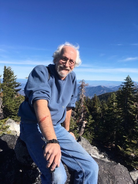
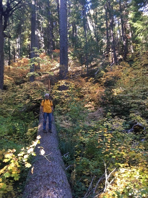
Mike Kohn in 2019 on Sugarloaf Peak in the Kangaroo Inventoried Roadless Area.
Mike Kohn was a loving and steadfast advocate for the Applegate Valley, a backcountry hiker, a recent Applegate Neighborhood Network Board Member, a loving husband, father, and grandfather. He had deep roots in the Applegate Valley and spent much of his spare time working for the health of the land and the community of the region. In his many years around the Applegate Valley he forged many friendships within the community and deep bonds with the land around him. He worked on many community projects, and for numerous years worked as treasurer for the Applegate Trails Association where he was an integral part of developing, designing, securing approval for and funding the development of the East Applegate Ridge Trail.
A year ago Mike offered to join the ANN board as treasurer and we were not only excited, but honored. Mike was a pleasure to work with and served ANN well with his organizational skills, his knowledge of the Applegate landscape and his love of this community. Mike passed away in Medford on May 7, 2020 during his third bout of esophageal cancer. We will truly miss him.
Next time you hike the East Applegate Ridge Trail and look across the beautiful Applegate Valley, thank Mike for his years of dedication, and in his memory, strive to serve this place like he did.
Thank you Mike. We will continue working on behalf of this watershed in your honor.
In gratitude, the Applegate Neighborhood Network board
Below is a memorial written by Mike’s wife and long-time Applegate Valley resident, Diana Coogle. Mike and Diana were married last year on May 18th.It is with great sadness that we will celebrate their first wedding anniversary this year with a memorial of Mike’s life.
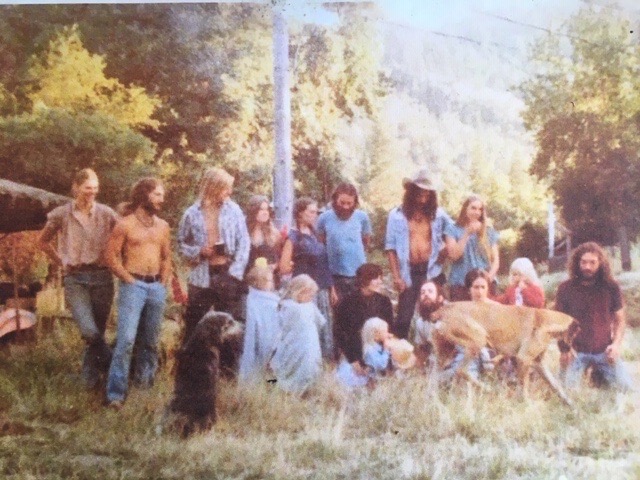
The Molto Bene community on Slagle Creek in the Applegate Valley in the 1970s. Mike is on the far right in this photo.
The death of Mike Kohn, at his home in Medford on May 7, 2020, has deprived the Applegate of one of its best friends.
Mike lived for many years at the Molto Bene commune on Slagle Creek, which he founded, with friends, in 1974, and where he raised his two daughters, Zoey and Allegra. Fifteen years ago he moved to Medford for easier access to his business, Home Comfort Hearth, which has stores in both Grants Pass and Phoenix. Although he never lost touch with his ties to the Applegate, his marriage to long-time Applegate resident Diana Coogle on May 18, 2019, after five years of hiking, skiing, and enjoying nature together, brought him into even closer touch to an area he loved.
In 2015 Mike joined the board of the Applegate Trails Association and served as its treasurer for several years. During that time he was instrumental in helping ATA get the East Applegate Ridge Trail approved and built. The East ART remained one of his favorite trails in the Applegate.
Mike Kohn and Diana Coogle helping build the East Applegate Ridge Trail in the spring of 2017.
Mike joined the board of the Applegate Neighborhood Network (ANN) in June, 2019 where, again, he served as treasurer. To have been a part of these organizations that protect the beautiful Applegate mountains and valleys was one Mike’s proudest and most significant contributions to a better world. He also participated in Jackson County’s juvenile justice program and served on the Phoenix Urban Renewal Agency and on the board of Options. He lived a life dedicated to that which was bigger than himself.
From the time he went to summer camp, as a child, on Lake Winnipesaukee, New Hampshire, he was an adventurer in and lover of nature. Throughout his life he enjoyed hiking, backpacking, cross-country skiing, sailing, and rafting. He climbed Mt. Katahdin on a solo trip, rafted the Grand Canyon on a family reunion, and took numerous trips to the Trinity Alps and Marble Mountains Wilderness Areas, some solo, some with Diana or with others. He went cross-country skiing in the southern Oregon Cascades with the Grants Pass Nordic Club. He and Diana did a backpacking trip in the Alpine Lakes Wilderness Area only two months after his surgery for esophageal cancer in 2015, a real tribute to his vitality. Two years later they did the 13-day, 98-mile Alta Via 2 hike in the Dolomite Mountains of northern Italy, which he considered the apex of his outdoor career.
Mike survived two bouts of esophageal cancer, in 2015 and again in 2018, just before his wedding. The third attack, in 2020, was swift and fatal. He will be missed throughout the Applegate for the inspiring work he gave to its environmental health and by many friends who live here and around the country. He was a good father, a doting grandfather, a generous boss, a loyal friend, a conscientious community member, and a loving brother and uncle. He was an exemplary community member, and for Diana, a boon companion.
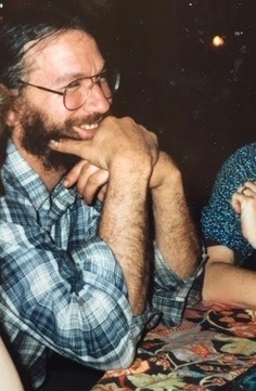
Mike in the 1970s.
Mike was born in Philadelphia in 1949, earned a BA in political science from Muhlenberg College in 1971, obtained Conscientious Objector status during the Vietnam War, and started his long business career by buying Chim Chiminey Sweepers in 1986. He was predeceased by his father (Lewis) and his mother (Patricia) and is survived by his wife, Diana Coogle; daughters Zoey Kohn (Scott Lochmann) and Allegra Stuart (Greg); grandchildren Morgan and Rosalie Stuart and Quincy and Nolan Lochmann; his sister, Janet Friedman; and his brother, Donald Kohn (Gail). Numerous nieces and nephews who loved him also survive him.
Mike reveling in the fall colors of the Applegate in the old-growth on the Middle Fork of the Applegate River along the Cameron Meadows Trail. Photo credit: Diana Coogle
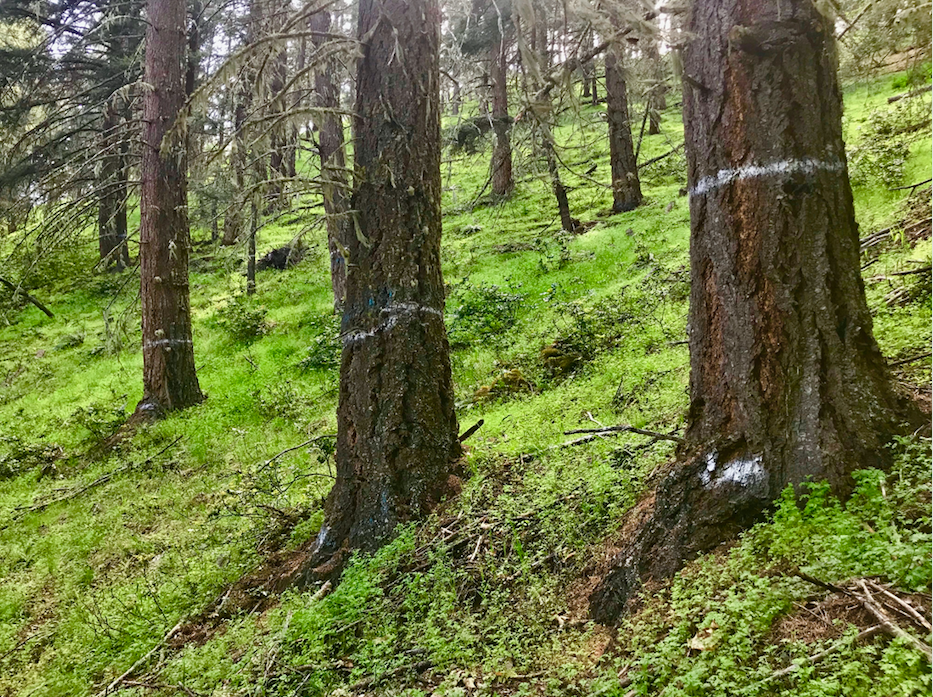
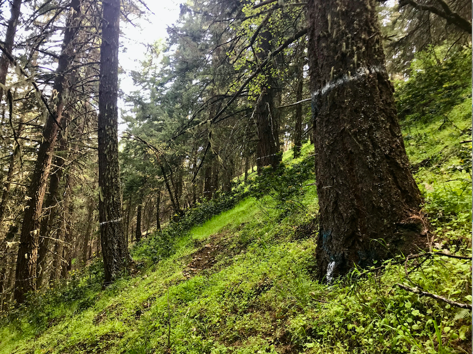
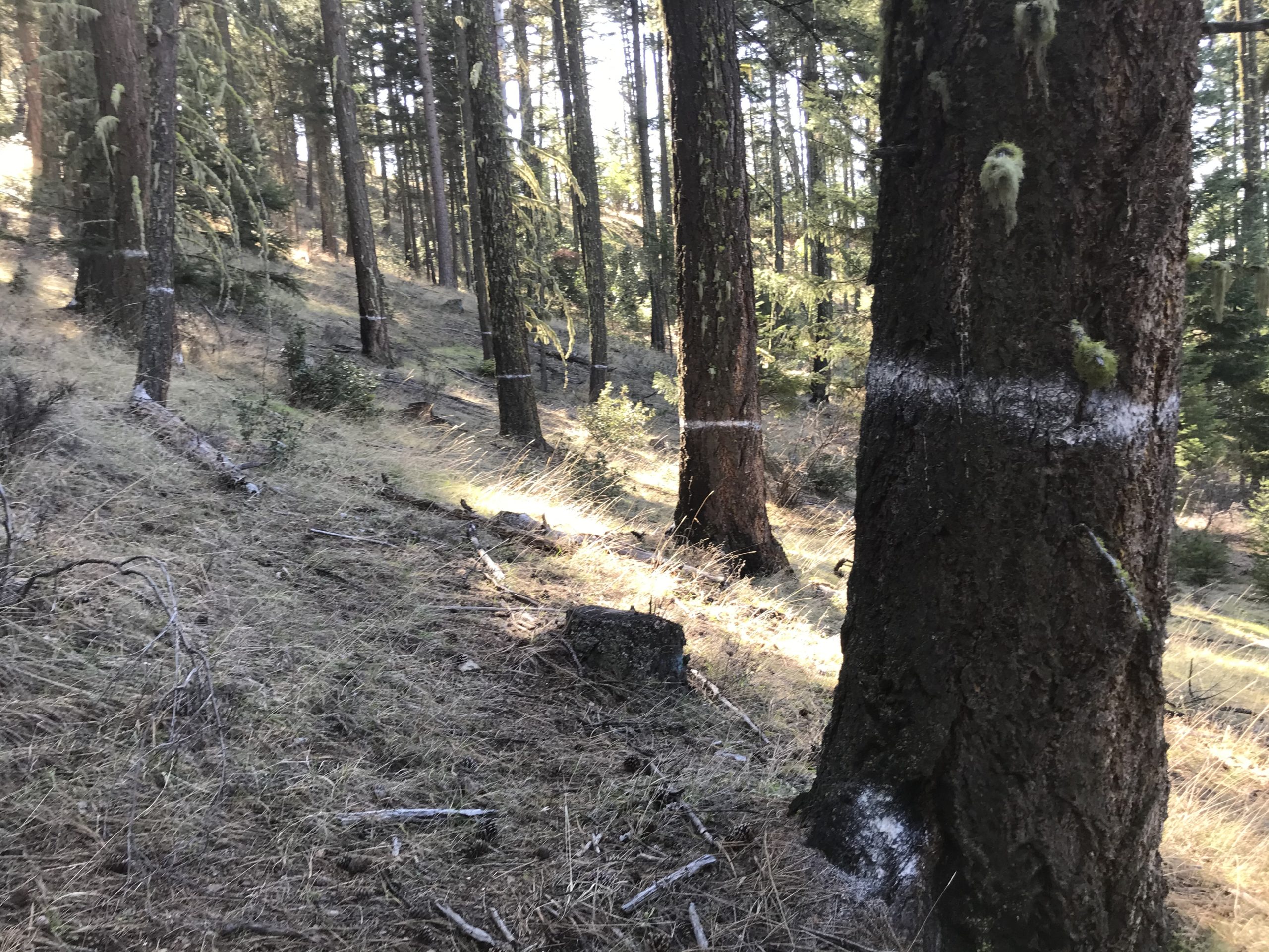
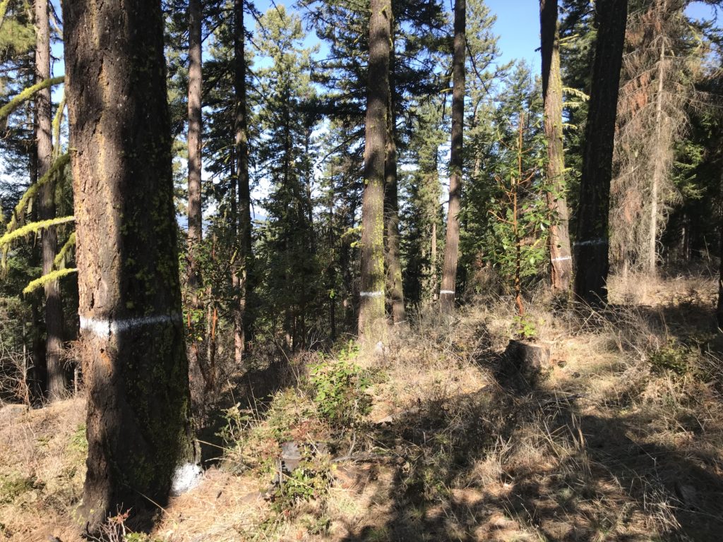
Open, highly fire resistant forest in the Wellington Wildlands proposed for group selection logging. The trees marked with white paint are proposed for removal in the Bear Grub Timber Sale.
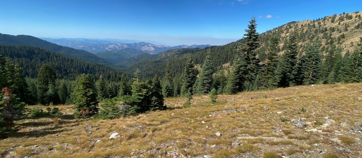
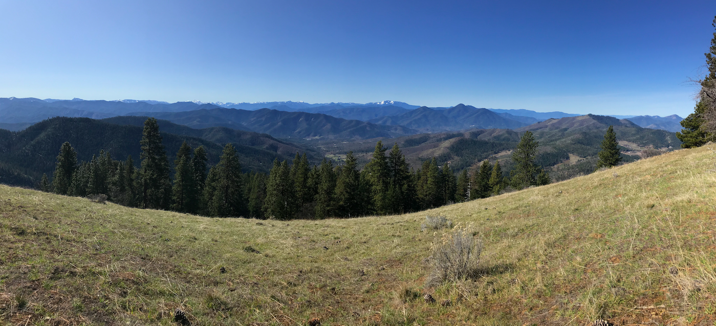
The BLM’s Bear Grub Timber Sale is proposing numerous group selection logging units in the 7,526-acre Wellington Wildlands, a spectacular roadless area in the mountains north of Highway 238. Located between the small communities of Ruch and Applegate, the Wellington Wildlands support a diverse mosaic of arid grasslands, dense chaparral, beautiful madrone groves and white oak woodland with scattered stands of conifer forest.
Recently the BLM marked these units, identifying whole groves of mature forest for removal. In response, ANN has been out monitoring the timber sale units and what we have found is extremely troubling. The BLM has marked large group selection clearcuts throughout these beautiful stands, targeting highly fire resistant forests of Douglas fir at the headwaters of China Gulch.
Targeting and Degrading Fire Resistant Forests
The forests in upper China Gulch contain large, old trees with thick, insulating bark and high canopies that shade the forest floor, naturally suppressing understory growth and limiting understory fuel loads. Many of the stands targeted for group selection logging are open and spacious, but maintain closed canopy conditions. These habitats represent the most fire resistant forests on the landscape, are dominated by large, old trees and contain mature to late successional habitats.
The group selection clearcuts proposed in the Bear Grub Timber Sale would eliminate forest canopy, remove fire resistant trees, dry out forested stands, increase solar exposure and wind speeds, while regenerating young, highly flammable vegetation. This will dramatically increase fire hazards and fuel loading in both wildland habitats and near homes and communities in the Applegate Valley.
This stand targeted for group selection logging at the headwaters of China Gulch is a model for natural fire resistance. Converting this stand from open, late successional forest to dense, young stands of regenerating trees and shrubs will dramatically increase fire hazards and damage habitat values.
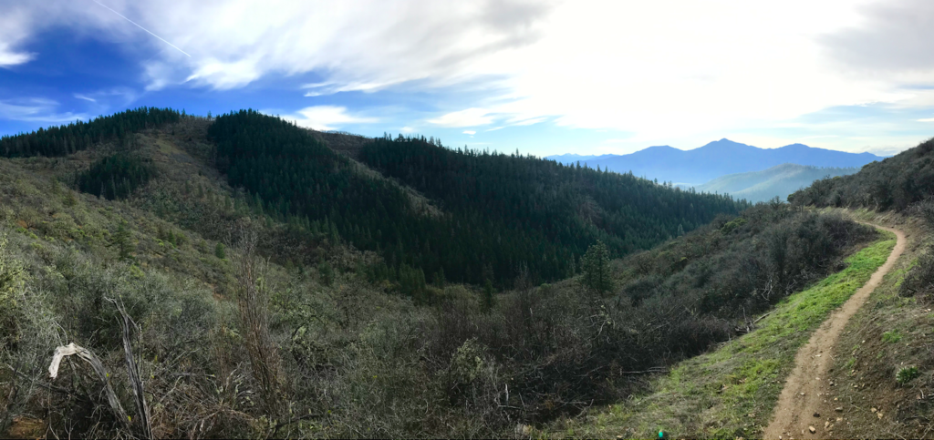
The forests targeted for logging are also located within the proposed trail corridor for the Applegate Ridge Trail. Although still conceptual, the central portion of the Applegate Ridge Trail is proposed to extend from Highway 238 near Forest Creek —where the current East Applegate Ridge Trail meets the highway — to Humbug Creek, traversing the Wellington Wildlands.
This conceptual trail would connect with the Jack-Ash Trail, creating a contiguous non-motorized trail system from Ashland to Jacksonville and west to Grants Pass. The trail would connect communities and wildland habitat on the Applegate/Rogue River Divide. The proposal is extremely popular and has received significant community support. Yet, while the community works to protect the important recreational, economic and ecological values of the Applegate Ridge Trail, the BLM is proposing to log off these important forests, even before the trail can be developed.
The Bear Grub Timber Sale would turn the proposed Applegate Ridge Trail corridor into a stumpfield. Which do you prefer? Clearcut public forest or intact wildlands and recreational opportunities?
Damaging Wildlife Habitat
These roadless forests are not only important for recreation and as a scenic backdrop to our homes and our wineries in the Applegate Valley, but they are also important for wildlife. They contain complex habitat conditions important for species like the Northern spotted owl and the Pacific fisher. Black bear, cougar, large herds of black-tailed deer and many other species use the protection of these mature, closed canopy forests. They provide nesting, resting, denning, and thermal cover habitat for a multitude of species, while the adjacent grasslands, oak woodlands, and chaparral provide abundant hunting and foraging habitats.
The Bear Grub Timber Sale will riddle these mature, closed canopy forests with staggered clearcuts, degrading late successional forest habitat and damaging important wildlife habitat.
Emitting Carbon and Reducing Climate Resilience
The Bear Grub Timber Sale proposes to remove whole groves of large, overstory trees and will have a lasting impact on carbon storage, emissions and climate mitigation. In fact, group selection logging would convert old, carbon rich forests into grasslands, chaparral fields or young regenerating forest that is not only less effective at storing atmospheric carbon, but less resilient to the droughts, fires and the climactic swings associated with climate change.
Maintaining these mature forest stands and canceling the Bear Grub Timber Sale would preserve habitat, maintain cool, shaded forest conditions, retain soil moisture, protect stream flows, and support both fire and drought resistance.
Whole groves of carbon rich forest are proposed for removal in the Bear Grub Timber Sale, limiting the forest’s natural ability to store carbon and mitigate climate change.
Stop Bear Grub!
The destructive logging proposed at the headwaters of China Gulch in the Bear Grub Timber Sale in the Wellington Wildlands will impact scenic values, recreational values, wildlife habitats, community fire safety, our local economy and our ability to adapt to climate change. The Ruch area is known for its scenic beauty, its wineries, and its world-class hang gliding. It is also a spectacularly beautiful place to live. If implemented, everything we love about the Applegate Valley would be impacted by the Bear Grub Timber Sale and portions of our beloved Wellington Wildlands would be destroyed.
At this critical time we must ask ourselves, what will we pass on to the next generation in the Applegate Valley? Clearcuts or Wildlands? We know which we prefer! Save Wellington Wildlands and Stop Bear Grub!
Below is a gallery of photographs depicting stand conditions in commercial logging units proposed in the Bear Grub Timber Sale at the the headwaters of China Gulch and in the Wellington Wildlands.
We have Stop Bear Grub Yard Signs!
Want an easy way to demonstrate your opposition to the Bear Grub Timber Sale? Do you live on a visible road in the Applegate or Rogue Valley? ANN has made Stop Bear Grub yard signs and they are currently available for a donation. Get them while supplies last!
Order a Stop Bear Grub yard sign now! Step 1 — Make a generous donation to ANN to help cover the cost of the yard signs. All donations over $20 will be eligible for a yard sign. Make donations here.
Step 2 — Contact ANN at the email address below and let us know what sign or signs you would like and we will contact you for pick up or delivery options: info@applegatesiskiyoualliance.org
Please donate now and show your support for the forests of Bear Grub!
Will we have forests like these for future generations? This photograph depicts conditions in unit 13-6 of the Bear Grub Timber Sale and directly adjacent to the East Applegate Ridge Trail. Nearly every tree in this photograph is marked for removal.
Applegate Neighborhood Network has been working with allies across the community and with the Klamath Forest Alliance to organize in opposition to the Bear Grub Timber Sale. One of the biggest concerns of local residents and affected landowners pertains to the increase in fire hazards associated with both group selection logging and heavy commercial thinning in the Bear Grub Timber Sale Planning Area.
The logging treatments proposed in the Bear Grub Timber Sale would remove hundreds, if not thousands of mature, fire resistant trees. These large, old trees support characteristics that significantly increase fire resistance, such as thick insulating bark, high canopies (e.g. crown base height) and closed canopy conditions. Once lost, the reestablishment of these conditions will take many decades to regenerate or restore, especially in the drier, more interior portions of the Applegate River Watershed.
Those who intimately know this region, know that any reduction in canopy cover will encourage additional, fire available fuel loading in the form of young, highly flammable vegetation (e.g. young trees and shrubs). The loss of canopy will also lead to more severe, fast moving wildfires by reducing canopy shade, drying out forested stands, increasing the development of fine fuels, regenerating dense woody understory growth, and by increasing wind speeds within affected stands.
Hikers on the East Applegate Ridge Trail enjoy forests proposed for group selection logging in the Bear Grub Timber Sale. Nearly every tree in this photograph is marked for removal.
After realizing what the Bear Grub Timber Sale would do to our forests and communities in the Applegate Watershed, ANN decided to analyze the impact that currently proposed or approved timber sales would have throughout the Medford District BLM and across Southwestern Oregon. Together with Klamath Forest Alliance we researched recently approved and proposed timber sales on lands across the Medford District BLM. What we found was unfortunate, but not necessarily surprising. According to BLM’s own analysis, the majority of the commercial logging currently approved can be expected to increase fire hazards for at least 20 years. In fact, since implementation of the BLM’s 2016 Resource Management Plan, 66% of the acreage approved for commercial logging will result in increased fire hazards and risks.
As residents of Southwestern Oregon we do not believe our public forests or our communities should be threatened with increased fire hazards and decreased forest resilience for short-term timber industry profits. We ask that residents of Southwestern Oregon contact their public officials and demand that the Bear Grub Timber Sale be canceled. We also ask that commercial logging methods such as group selection logging, regeneration logging and heavy commercial thinning that significantly reduce canopy cover and increase fire risks be discontinued on public lands.
At ANN we work hard to protect, defend and restore our local watersheds, but we also work to understand how that relates to the bigger picture, and that is what this report is all about.
A view southwest into the Little Applegate River Watershed and across the Siskiyou Crest from Deming Ridge. The forest surrounded by grassland in the foreground is proposed for group selection logging in the Bear Grub Timber Sale.
The Deming Ridge Units of the Bear Grub Timber Sale
The Medford District BLM has proposed the Bear Grub Timber Sale in the mountains between Ruch in the Applegate Valley and Talent in the Rogue Valley. The Bear Grub Timber Sale includes units along “Deming Ridge,” a beautiful ridgeline extending west from the face of Anderson Butte into Sterling Creek and the Little Applegate River Watershed.
The north-facing slope of Deming Ridge drains into Grub Gulch, a small tributary of Sterling Creek, and is dominated by forests that have been heavily logged in previous BLM timber sales. These forests include tree plantations created by clearcut logging, heavily thinned forests and high graded conifer stands, as well as small patches of mature, closed canopy forest. Because the area has been degraded by industrial logging in some locations, it is incredibly important to protect the remaining intact, mature forests, as they are vital for wildlife habitat, fire resilience and climate stability.
Looking east towards Anderson Butte across the south-facing slopes of Deming Ridge. The forests in the background, below the open summit of Anderson Butte, include units 2-2a, 2-2b and 15-2 in the Bear Grub Timber Sale.
The south-facing slopes of Deming Ridge, above Deming Gulch, are varied, beautiful and support a more natural mosaic of vegetation. Dominated by broad swaths of arid grassland and lined in dense chaparral, oak woodland, open-grown ponderosa pine and dry mixed conifer forests, these south-facing slopes are open, sunbaked and largely too arid to support closed canopy forest habitats. Patches of dry mixed conifer forests are mostly limited to growing in narrow “stringers” or corridors of habitat running vertically down the face of the ridgeline. These corridors of forest are often precariously perched on harsh, exposed slopes and are surrounded by non-forest plant communities.
They also provide important wildlife habitat, including nesting habitat for species such as the great gray owl, denning habitat for the Pacific fisher, and thermal cover for large herds of overwintering black-tailed deer. These stringers of forest are also extremely important for habitat connectivity by providing corridors of mature forest habitat, connecting local watersheds and providing dispersal corridors across the region.
The Impact of BLM’s 2014 Sterling Sweeper Timber Sale
Portions of Deming Ridge were previously logged using “group selection” prescriptions in the BLM’s 2014 Sterling Sweeper Timber Sale. This recent timber sale demonstrates the impact of group selection logging and the problems it tends to create.
A group selection harvest in 2014 shortly after implementation of the Sterling Sweeper Timber Sale. This group selection clearcut was logged in mature, closed canopy Douglas fir forest on the summit of Deming Ridge.
Six years after implementation, the Sterling Sweeper Timber Sale cleared stands of large, fire resistant trees, creating habitats that are drier, more windswept, more flammable and choked with dense understory growth. Having filled in with young, dense understory vegetation, fire risks have significantly increased within the footprint of previous group selection cuts, creating additional fuel hazards and encouraging more severe fires in the future.
Dense understory growth regenerating six years after the Sterling Sweeper Timber Sale in a small group selection clearcut. Notice the open, exposed conditions, dense woody regeneration and general lack of fire resistance.
Further out the ridgeline, beyond the group selection cuts from the 2014 Sterling Sweeper Timber Sale, the BLM has now proposed two new timber sale units on Deming Ridge. These include a north-facing Douglas fir stand and a large, southwest-facing conifer stringer proposed for logging in the Bear Grub Timber Sale.
North Slope Deming Ridge
Bear Grub unit 3-1 reaches to the summit of the ridge, mingling with the south-facing grasslands overlooking the Little Applegate Valley, and extends down the northern slope of Deming Ridge toward Grub Gulch. These north slopes naturally support closed canopy forests of Douglas fir, but have been heavily logged in previous timber sales.
Although much of Deming Ridge’s north-facing slope consists of young, plantation stands, Bear Grub unit 3-1 contains mature conifer forest. The upper portion of the stand is dominated by large, fire resistant trees and supports relatively intact canopy conditions. The filtered canopy is suppressing understory growth, maintaining a light grassy understory and naturally moderating fuel loads.
The upper end of Bear Grub Timber Sale unit 3-1 on the north slope of Deming Ridge contains relatively open groves of mature forest.
Lower on the slope the forest is more productive, but has been more heavily logged and canopy conditions are more heavily compromised. Previous logging treatments included both commercial thinning and small group selection clearcuts interspersed throughout the stand. Dense patches of regenerating Douglas fir trees have grown up in the group selection openings, dramatically increasing fire risks in affected stands.
Young flammable growth in a previous group selection cut in Bear Grub unit 3-1.
Dense growth from previous logging, with overstory trees marked for removal in Bear Grub unit 3-1.
Despite the disastrous results of previous group selection logging in the area, the BLM is now proposing to log the last relatively natural forests on the northern slopes of Deming Ridge, using an even more aggressive approach to group selection logging. The BLM has “marked” the trees in Bear Grub unit 3-1 with white paint, clearly showing which trees they intend to log. The timber sale mark in unit 3-1 demonstrates that whole groves of dominant overstory trees would be logged if the Bear Grub Timber Sale is approved.
South Slope Deming Ridge
Ponderosa pine in the small terrace below Deming Ridge.
The BLM has also identified the largest forested corridor extending down the southern face of Deming Ridge as a group selection logging unit. Completely surrounded by dry grasslands and parched oak woodlands, the forest exists in a sensitive niche habitat that could easily be impacted by commercial logging.
Just below the summit of Deming Ridge a small, flat terrace created by an ancient landslide supports an open forest of large, old ponderosa pine. Due to the relatively open conditions, the surrounding grasslands spill into the woodland, creating a rich understory of grasses and herbs. Tree distribution is patchy, diverse and open enough to support the regeneration of healthy, young ponderosa pine saplings.
As the slope steepens below the piney terrace, mature groves of Douglas fir begin to dominate. Although widely spaced, the large overstory trees create a relatively closed canopy and cast shade throughout the stand. The stand supports an open, grassy understory and minimal fuel loading beneath groves of large, open-grown, overstory trees. Although not old-growth or even late successional forest, if left alone this stand will mature into an important late successional habitat with exceptional fire resistance. We must protect forests like this now, so that fire resistant old-growth forests are more abundant in the future!
Mature, fire resilient forest targeted for group selection logging on the southern face of Deming Ridge. The trees marked with white paint are marked for removal, including nearly every tree in this photograph.
The BLM has marked whole groves of mature forest for removal on the southern face of Deming Ridge, using a group selection prescription throughout this isolated conifer habitat.
The impact of Group Selection Logging on Deming Ridge
Although both north- and south-facing slopes will respond differently to the canopy removal and soil disturbance proposed in the Bear Grub Timber Sale, the development of dense, woody understory growth will be universal. Judging from the response of past BLM logging treatments in the Applegate Watershed, the south-facing slopes will compensate for canopy loss and large tree removal by regenerating dense stands of manzanita, deerbrush, buckbrush, madrone and young conifer trees. North-facing slopes will respond with an abundance of young madrone and Douglas fir.
A whole stand of mature Douglas fir marked for removal on the southern face of Deming Ridge.
In both cases, large, fire resistant trees will be removed and dense, young growth will proportionally increase throughout the stand. Ambient air temperature, exposure to drying winds and direct solar radiation will also increase drought stress and dry forest fuels, leading to more intense wildfires, longer fire seasons, and increased levels of overstory mortality. Trees around the edges of newly created group selection clearcuts will be more susceptible to wildfire effects, windthrow, drought, and other forms of mortality and stress.
By removing whole groves of large, dominant trees, the Bear Grub Timber Sale will also lead to a significant loss of stored carbon and a long-term loss of carbon storage capacity. The mature forests proposed for logging currently buffer against the effects of climate change, provide refugia for wildlife, and behave as carbon sinks necessary for climate stabilization. The BLM is proposing to replace these beautiful forests and carbon sinks with stump fields that contribute to greenhouse gas emissions, degrade natural forest habitats, and provide little wildlife habitat value.
Deforestation and forest degradation is not only occurring in tropical rain forests throughout the Amazon, Indonesia and in Africa’s Congo River Basin, it is also occurring before our very eyes throughout western North America on both public and private land, including right here in the Siskiyou Mountains. While the BLM works to increase timber production, climate sinks will be transformed into sources of carbon pollution and future climate resilience is being compromised. Unfortunately, the BLM is managing these lands to produce short-term profits for the timber industry, not for the long-term health of forests and communities or for the ecosystem services they provide.
The mark on the southern face of Deming Ridge demonstrates that large, fire resistant trees are being targeted by the BLM for removal in the Bear Grub Timber Sale.
Despite claims by the BLM that the Bear Grub Timber Sale is forest restoration or fuel reduction, the tree removal mark demonstrates otherwise. Instead, the Bear Grub Timber Sale is a Trump-era timber grab, a return to clearcut logging on federal land, and a major step in the wrong direction. These are public lands. The health of our forests, the health of our climate and safety of our communities should not be sacrificed for short-term timber industry profits. Please join us in protecting our communities and defending our public forests. Stop Bear Grub!
The forests in this photograph are located in the Wellington Wildlands, at the headwaters of China Gulch and are identified by the BLM as potential logging units in the Bear Grub Timber Sale.
Last year ANN successfully fought to protect large portions of the Wellington Wildlands from the Middle Applegate Timber Sale. The Wellington Wildlands is a 7,526-acre roadless area west of Ruch, Oregon in the Applegate Valley. The area is known for its intact oak woodlands, beautiful grasslands, dense fields of chaparral, and dry mixed conifer forests. The Middle Applegate Timber Sale had included the entire roadless area within the “planning area.” Yet due to significant opposition by ANN and others in the region, the BLM withdrew the Middle Applegate Timber Sale and we thought that the Wellington Wildlands was saved!
Just days later, the BLM announced a new timber sale called the Bear Grub Timber Sale. The westernmost units in the Bear Grub Timber Sale are located in upper China Gulch, just outside Ruch and inside the eastern edge of the Wellington Wildlands. Much of China Gulch contains a mosaic of sunbaked south-facing slopes colonized by chaparral and oak woodland overlooking the Applegate Valley.
The unlogged forests at the headwaters of China Gulch support mature, fire resistant forests. Current canopy conditions are limiting understory growth and maintaining resilient conditions.
At its headwaters, surrounded by oak and chaparral, China Gulch contains a significant block of unlogged forest. Some of these forests support an overstory component of old Douglas fir trees. These old firs appear to have survived the large wildfires that swept through this area in the 1930s, growing in small groves, as fire mediated clumps, or as scattered individuals within the larger island of conifer forest. Soot from the 1930 fires is still evident on the bark and in deep fire scoured “cat-faces” on the uphill side of some of the largest, oldest trees. Other trees have regenerated since the fires, creating a mosaic of younger stands and maturing forest.
Closed mixed conifer forest in the Wellington Wildlands proposed for logging in the Bear Grub Timber Sale.
In China Gulch, where conifers dominate, cast heavy shade and grow in closed canopy stands, fuel conditions are often moderated supporting little shrubby growth and tall canopies. The combination of dense canopy shade and relatively arid conditions tends to discourage understory growth, and although marginal and dry, these forests have managed to grow some fairly large, old, fire resistant trees.
Scattered old forest supports cool, shaded microclimates at the headwaters of China Gulch.
If logged, microclimate conditions will shift from a cool, shaded forest to a sunbaked, windswept habitat of sparse forest, logging slash, dense brush, abundant understory conifer and hardwood regeneration, and dry grass. Fuel and fire risks will only increase adjacent to the community of Ruch and for the residents living below in China Gulch. Commercial logging will also reduce wildlife habitat values by degrading some of the last unlogged, closed canopy forests in the China Gulch watershed.
The proposed China Gulch units in the Bear Grub Timber Sale are also located directly on the proposed route of the central part of the Applegate Ridge Trail (the proposed Center Applegate Ridge Trail), a non-motorized trail proposal intended to connect Grants Pass and Jacksonville, Oregon. Not only is the BLM proposing to implement 4 acre clearcuts along the first official section of trail, the East Applegate Ridge Trail, but they are also proposing to potentially log beautiful portions of the proposed Center Applegate Ridge Trail as well.
A hiker on the Center Applegate Ridge Trail looks across the headwaters of China Gulch to the unroaded forests proposed for logging in the Bear Grub Timber Sale.
The Center Applegate Ridge Trail, is proposed to extend from Highway 238 to Humbug Creek through the Wellington Wildlands. The proposed logging activity will degrade scenic values, impacting outdoor recreation opportunities for visitors and for surrounding southwest Oregon communities. They will also be highly visible from numerous local wineries in the Ruch area, impacting the scenic values that fuel the Applegate Valley economy
The so-called “benefits” of logging the Wellington Wildlands are being inflated and misrepresented by the BLM. Timber volumes in these particular stands are extremely minimal. The stands are spread out and sparse, and unless the last remaining old forests are removed, an economically viable timber sale would be difficult to create.
The BLM is mandated under the O&C Act to maintain wildlife, watershed and recreation values, while implementing a sustainable timber harvest. Yet, it is unlikely that these values or future timber harvests can be sustained in the arid forest habitats of the Applegate Valley.
This stand of bigleaf maple and large Douglas fir in China Gulch is identified for logging in initial proposals for the Bear Grub Timber Sale.
The China Gulch units are not yet marked with timber sale boundaries or for tree removal. This means the BLM could still cancel the block of timber sale units proposed up China Gulch and keep the Wellington Wildlands the intact corridor of habitat it is today. These units could be “considered but eliminated from detailed analysis”and dropped from the proposal in the Environmental Analysis. The impacts are simply too great for wildlife, for outdoor recreation, scenic values, wilderness values and nearby communities.
Our community, including many residents whose property directly surrounds the wildlands, have demonstrated support for protection of the Wellington Wildlands. We are proud of the wildlands that surround us and strongly support their protection. The protection of these wildlands will ensure the quality of habitat in our region, our quality of life in southwest Oregon, and the burgeoning outdoor recreation, tourism and amenities-based economy of the Applegate Valley. Unfortunately we still have to say it: SAVE WELLINGTON WILDLANDS!
Please consider contacting BLM officials to ask them to support our local recreation economy, reduce fire risks near our communities, maintain scenic values and protect the Wellington Wildlands, the East Applegate Ridge Trail, the Jack-Ash Trail, the Sterling Ditch Trail and Bald Mountain by canceling units in these important habitats and recreation areas. Also please ask the BLM to cancel all “group selection” logging prescriptions and focus on non-commercial fuel reduction and thinning adjacent to homes and communities. We believe that the dry forests of the Applegate Valley simply cannot maintain fire resistance or important resource values if the level of timber harvest proposed by BLM in the Bear Grub Timber Sale is implemented.
The East Applegate Ridge Trail winds down to Highway 238 through the lower Poorman’s Creek watershed. The forests across the canyon in this photograph are proposed for “group selection” logging in the Bear Grub Timber Sale.
Do you love the East Applegate Ridge Trail and the forests of the Applegate? With your help we can defend Applegate forests from BLM logging.
The East Applegate Ridge Trail
As a recent addition to our local trail network, the East Applegate Ridge Trail (East ART) quickly became one of the most popular and cherished outdoor recreational experiences in the Applegate Valley and southwestern Oregon. With abundant community support, the Applegate Trails Association worked for many years to design the trail, secure BLM approval, fund, and build the East Applegate Ridge Trail. Local residents and visitors now enjoy the trail for its accessibility, incredible vistas, open grasslands, oak woodlands, chaparral stands and low elevation forests. It is a treasure of the Applegate Valley and a source of pride for our local community.
Unit 13-6 of the Bear Grub Timber Sale is located directly adjacent to the East Applegate Ridge Trail and proposes to log large, fire resistant trees in small clearcuts up to 4 acres wide and across 30% of the stand. The trees marked with white paint would be removed and include every tree in this photograph.
The Bear Grub Timber Sale
Unfortunately, the beautiful low elevation forests either on or adjacent to the East Applegate Ridge Trail are proposed for logging in the BLM’s new Bear Grub Timber Sale. The timber sale extends from China Gulch west of Ruch to Forest Creek, Poorman’s Creek, Sterling Creek and the mountains above Talent, Oregon in the Rogue Valley.
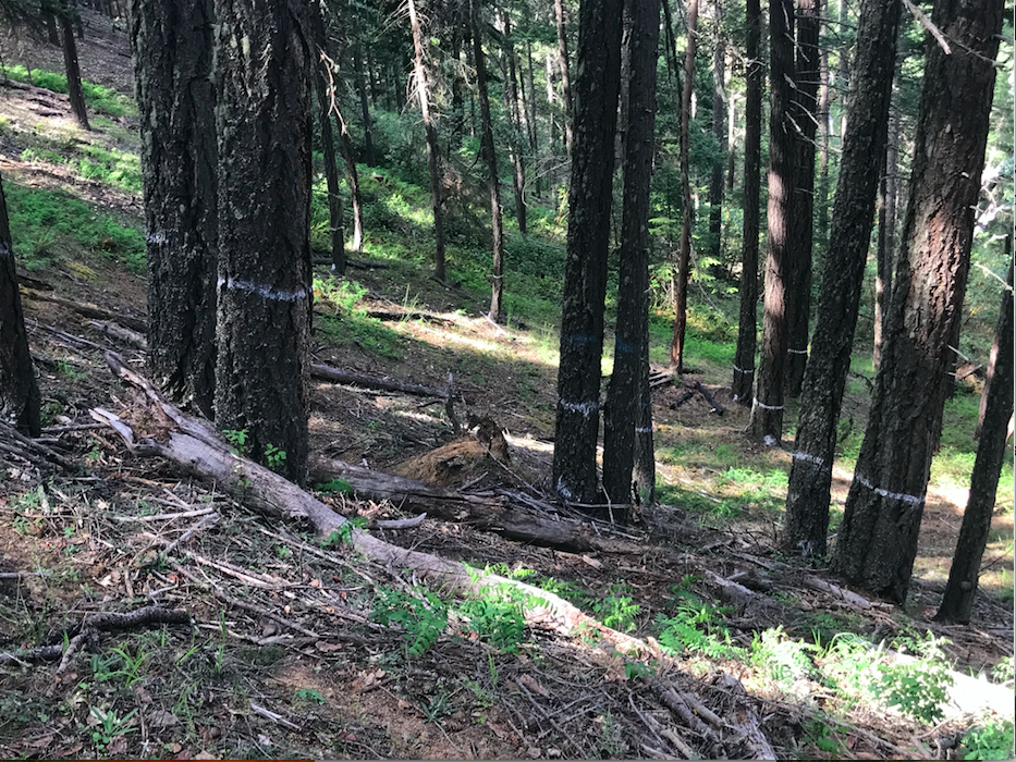
Open stand conditions dominated by large, old trees in unit 13-1 north of the East Applegate Ridge Trail. This stand hasn’t been marked for logging yet, but boundaries are defined.
The forests of the Bear Grub Timber Sale and the impact of logging
The dry forests in the area include mature mixed conifer forests with scattered old-growth trees. They cling to protected north- and east-facing slopes within a diverse habitat mosaic of oak woodland, chaparral and dry grasslands. The Bear Grub “planning area” supports the driest forested habitats in Western Oregon. This aridity makes the forests of the Applegate foothills particularly susceptible to microclimate alterations associated with commercial logging.
In these dry forests logging that removes excessive levels of canopy and large dominant trees can often lead to accelerated overstory mortality (i.e. even more trees die after logging operations) and stand desiccation, as well as dramatic increases in understory fuel loads and fire risks. The Bear Grub Timber Sale is a particularly troubling example of this phenomena as it is located adjacent to many homes and residential areas around Ruch and the Little Applegate Valley.
Unit 13-6 along the East Applegate Ridge Trail would log large, fire resistant trees and replace them with at least 150 young trees per acre, dramatically reducing habitat values and increasing fire risks. All trees marked with white paint, including nearly all the large trees in this photograph, would be removed in the group selection logging prescription.
Expediting the process and ignoring the public
For many years ANN has been advocating for land management activities that sustain our environment, maintain our biodiversity, protect wildlands, reduce fire risks to nearby communities, and address the concerns of the Applegate Valley community; unfortunately, in the Bear Grub Timber Sale, the BLM is heading in the opposite direction. In fact, the project marks a troubling transition towards heavy industrial logging and represents a lack of commitment to community collaboration and engagement. Not only has BLM been planning this timber sale without notifying or engaging community interests or neighboring landowners, they have also failed to schedule a single public meeting about this potentially damaging project. ANN is aware that local landowners living adjacent to Bear Grub units in the Applegate Valley have reached out to the BLM requesting a public meeting. ANN has also contacted local BLM officials on six occasions since November 2019 requesting a public meeting, yet the BLM has failed to accommodate the requests of local residents for a public meeting about the Bear Grub Timber Sale.
Despite essentially no public outreach, transparency or collaboration occurring around the Bear Grub Timber Sale, the BLM is expediting the process and has already begun marking unit boundaries and trees proposed for removal.
The return of clearcut logging on public lands in the Applegate Watershed
Although only some of the units located on or near the East Applegate Ridge Trail have been marked for tree removal, a clear pattern is evident: the Bear Grub Timber Sale is implementing “group selection” logging, a form of incremental clearcut logging. Under a “group selection” prescription, numerous patches of mature forest up to 4 acres can be marked for complete or near complete removal in each logging unit. These small clearcuts can be scattered throughout large patches of forest and can occur on up to 30% of a given timber sale unit. It is likely that group selection logging will be used throughout the entire Bear Grub Timber Sale, and not just in the area of the East Applegate Ridge Trail.
How group selection logging works: For example, if the BLM identifies a 100 acre unit of mature forest, 30 acres could be completely removed in a patchwork of clearcuts rather than in one large “cut block.” The guidelines for group selection logging (i.e. small clearcuts) are outlined in the BLM’s 2016 Resource Management Plan (RMP) and are being proposed in the Bear Grub Timber Sale.
The Bear Grub Timber Sale will increase wildfire risks to adjacent property owners and communities
The loss of canopy from group selection logging will dramatically increase wildfire risks by increasing understory fuel loads and removing whole groves of fire resistant trees. The group selection cuts will also increase sunlight, ambient air temperatures and wind speeds within “treated” stands, creating the potential for more intense fires and drier forest fuels.
A group selection cut in unit 14-2. Every tree in this photograph is marked for removal. The stand is located on a north-facing slope directly across from the East Applegate Ridge Trail. Take note that the existing canopy is suppressing understory growth and maintaining highly fire resistant stand conditions. If this forest’s canopy is removed by BLM logging, dense young growth will replace the tall, fire resistant trees, dramatically increasing fire risks.
Each opening created through “group selection” logging will respond with a profusion of understory fuel in the form of regenerating thickets of woody shrubs, young hardwoods and highly flammable young conifer saplings. If less than 150 young trees per acre do not regenerate, the BLM will plant them, creating a plantation-like structure that is particularly susceptible to high severity fire effects. Rather than reducing fire risks the logging will create conditions highly conducive to fast moving, high severity fires.
We are hearing reports from concerned community members in the Applegate that BLM is marking timber sale unit boundaries in advance of the Bear Grub Timber Sale. Many Bear Grub units will be located directly adjacent to homes and residential communities. If these timber sale units are implemented, fire risks will be heightened in communities around the Applegate Valley. ANN has been out to visit some of the units next to homes and private properties and we will continue to ground-truth as the timber sale marking progresses. Are you seeing BLM property boundary marking next to your land? If so, let us know at: info@applegatesiskiyoualliance.org
Climate, carbon and the Bear Grub Timber Sale
The Bear Grub Timber Sale will have disastrous consequences for the climate and the ability of local forests to absorb carbon from the atmosphere. By clearing up to 30% of mature forest stands, the project will not only release carbon into the atmosphere, but it will also limit carbon sequestration across vast tracts of BLM land in the Applegate Valley by removing large, old trees. Without a doubt, the Bear Grub Timber Sale will be a net loss for our climate. In fact, recent research conducted at Oregon State University demonstrates that industrial logging is the top producer of greenhouse gas emission in Oregon, accounting for up to 40% of all carbon emissions in the state.
To help prevent the worst impacts of climate change we need to be managing our forests for maximum carbon sequestration, which can be achieved by maintaining mature forest habitats. The amount of carbon sequestered by forest ecosystems plays an important role in regulating atmospheric levels of carbon dioxide. The potential to store additional carbon in Pacific Northwest forests is among the highest in the world; therefore, forest defense is climate defense.
Impacts to Wildlife
Group selection logging by its very nature will fragment and degrade forest habitats, creating an abundance of small clearcuts throughout otherwise mature, closed canopy forest. This will impact denning and resting habitat for the Pacific fisher, as well as, nesting, roosting and foraging habitat for the threatened Northern spotted owl. Great grey owls are known to nest in the area and will be impacted by the loss of canopy and forest habitat. Long-term snag and coarse wood recruitment will also be impacted, degrading habitat for terrestrial salamanders, bats, cavity nesting birds, raptors, and other wildlife species.
Open fire resilient forest marked for removal. All trees in this photograph would be logged in unit 14-2 of the Bear Grub Timber Sale.
The thermal cover associated with mature forest is also important for temperature moderation during both the summer and winter months, providing protection for the region’s wildlife. Thermal cover requires closed canopy habitat conditions over relatively large areas and is an important habitat component for deer, elk, black bear and other wildlife species. Group selection logging would eliminate thermal cover in many stands by significantly fragmenting forest canopies.
Community Impacts
Group selection logging in the Bear Grub Timber Sale will also damage the scenic beauty of the East Applegate Ridge Trail, including its spectacular vistas and mature mixed conifer forests. The impacts to this popular trail will degrade the quality of life for Applegate and Rogue Valley residents and visitors who regularly hike, mountain bike, ride horseback through the forests of the area, or hang glide off Woodrat Mountain .
Unit 13-1, north of the East Applegate Ridge Trail, contains mature fire resilient forest directly above the residential communities on Highway 238. The shade of closed canopy forests keep the slopes cool and moist, while also suppressing understory growth and fuel development. Logging will only make this forest and the communities below less fire resilient. This stand hasn’t been marked for logging yet, but boundaries are defined.
The Bear Grub Timber Sale represents the reintroduction of clearcut logging on public lands in the Applegate Valley and is a massive step backwards for the BLM. It demonstrates that timber values, not fuel reduction or “forest restoration” are driving forest management on the Medford District BLM. Please help us protect the forests of the Applegate Valley. Support outdoor recreation, fuel reduction and fire resilient communities. Stop Bear Grub!
Stay tuned as ANN schedules upcoming hikes into the Bear Grub Timber Sale and a public meeting about the Bear Grub Timber Sale in Ruch. With your help we can protect the beautiful forests of the Applegate and the East Applegate Ridge Trail!
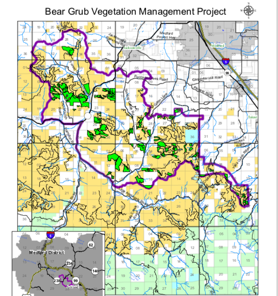
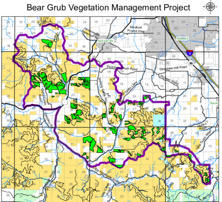
The green polygons spread across the Bear Grub Planning Area (outined in purple) are a mixture of commercial timber sale units and non-commercial fuel reduction. Currently the BLM has not publicly disclosed which units will be commercially harvested, but ANN has been monitoring BLM activities to provide information to the community.
To review or download the BLM’s publicly available information and maps follow this link.
The IVM Project proposes commercial logging and road construction in Late Successional Reserve forests like those in upper Mungers Creek above Williams, Oregon.
2019 was a busy year for folks at ANN. With 2019 coming to a close, we are looking back at the last year and looking forward to 2020.
In 2019 ANN opposed BLM timber sales, Forest Service off-road vehicle trails and Josephine County public land grabs. We also supported numerous important public land stewardship and restoration projects, including the closure of illegal off-road vehicle routes on the Siskiyou Crest, trash clean up in the Hinkle Lake Botanical Area, pollinator restoration projects along the Applegate River, and reasonable community wildfire protection and restoration projects in the Upper Applegate Watershed Restoration Project.
Middle Applegate Timber Sale & Wellington Wildlands
In 2019 we focused our energy on protecting and defending the Wellington Wildlands from the BLM’s Middle Applegate Timber Sale. The BLM had proposed the Middle Applegate Timber Sale with Wellington Wildlands at the heart of the planning area. ANN, our conservation allies, and Applegate Valley filmmakers Ed Keller and Greeley Wells createdSaving Wellington, a short film about the Wellington Wildlands and the threat of the Middle Applegate Timber Sale.
ANN worked through the spring and summer of 2019 organizing five film showings in Grants Pass, Jacksonville, Ashland and the Applegate Valley. Saving Wellington was also accepted into the Ashland Independent Film Festival. Hundreds of people attended film showings and were inspired to speak on behalf of Wellington Wildlands.
We organized a film showing with representatives of the Applegate Valley community and the BLM. At this meeting we submitted a petition with 500 signatures asking the BLM to withdraw the Wellington Wildlands from the Middle Applegate Timber Sale “planning area.”
We also organized a public hike into the Wellington Wildlands, spoke with our elected officials and wrote articles for the Applegater Community Newspaper.
Finally, in late September 2019, the BLM withdrew the Middle Applegate Timber Sale and Wellington Wildlands was saved!
Bear Grub Timber Sale
Old-growth forest in Bear Grub Timber Sale unit 21-2 on Bald Mountain.
Not long after the BLM withdrew the Middle Applegate Timber Sale they announced a new timber sale proposal in the mountains around Ruch, Little Applegate and Talent, Oregon in the Rogue River Valley. The sprawling timber sale proposal includes the eastern portions of Wellington Wildlands in the China Gulch Watershed, as well as timber sale units on the East Applegate Ridge Trail, the Jack-Ash Trail, the Sterling Mine Ditch Trail, and in old-growth forests on Bald Mountain.
In 2020 ANN expects to work hard for the forests surrounding Ruch, Sterling Creek and in the mountains between the Little Applegate River canyon and the Rogue Valley.
IVM Project
The Late Mungers Project proposes to log large portions of the Murphy Creek Watershed (pictured above) as part of the IVM Project. ANN will be working in 2020 to protect the Applegate’s forests, watersheds and scenic vistas.
The Medford District BLM is also proposing an unprecedented project that would affect the entire Applegate River Watershed. This project, called the Integrated Vegetation Management for Resilient Lands (IVM) Project, would strip the public of its right to meaningfully participate in public land management planning, and eliminate the current requirement that the agency conduct site specific scientific analysis for individual timber sales or fuel reduction projects. The IVM project would allow the BLM to log up to 4,000 acres per year and build 10 miles of new road. Over a ten year period this project would allow 25,000 acres of commercial logging and 90 miles of new road construction.
To make things even worse, the IVM project is focused on logging Late Successional Reserve (LSR) forests, Lands with Wilderness Characteristics (LWC), Areas of Critical Environmental Concern (ACEC) and other conservation areas.
ANN will be working hard in 2020 to maintain public involvement in the land management planning process, to support science-based conservation efforts and to oppose widespread commercial logging in important conservation areas across the Applegate River Watershed.
Late Mungers Timber Sale
Old forest proposed for logging on Mungers Butte in the BLM’s Late Mungers Timber Sale.
Operating as if the still unauthorized IVM project was already approved, the Medford District BLM began secretly working on a project “tiered” to the IVM proposal. This project, called the Late Mungers Timber Sale, proposes vast commercial logging and fuel reduction activities in the mountains west of the Williams Valley, and east of Murphy, Oregon. The entire area is located within a large Late Successional Reserve, previously set aside as habitat for the Northern spotted owl.
The BLM has proposed to log this important Northern spotted owl reserve with commercial units on Mungers Butte, Powell Creek, Mungers Creek, and China Basin in the Williams area. Numerous units are also located in and around Murphy Creek.
ANN has taken the lead on this project, informing the public, engaging the BLM and conducting extensive on-the-ground field monitoring of timber sale units. We will be working hard in 2020 to protect the Williams and Murphy Creek Watersheds from the BLM’s Late Munger Timber Sale.
Off-Road Vehicle Closures
Closing down an illegal off-road vehicle trail in the Big Red Mountain Botanical Area.
For a number of years ANN has been working alongside Klamath Forest Alliance to produce Off-Road Vehicle Monitoring Reports. These reports highlight the need for enforcement, monitoring and physical closures throughout the Siskiyou Mountains. Our goal is to document the impacts associated with unauthorized motor vehicle use, reduce or eliminate those impacts, and advocate for the closure of illegal motorized trails.
In 2019 ANN worked with the Forest Service to close one damaging off-road vehicle route in the Big Red Mountain Botanical Area. We also helped to monitor, secure and enforce the existing closure at the Hinkle Lake Botanical Area at the headwaters of Carberry Creek and adjacent to the Red Buttes Wilderness Area.
In 2020 ANN will be working to secure more motor vehicle closures on the Siskiyou Crest in Botanical Areas, roadless areas, and in sensitive habitats throughout the Applegate watershed.
Wild and Scenic River Nominations
ANN is proposing the Middle Fork of the Applegate River as a Wild and Scenic River.
ANN does not only oppose damaging projects, we also work to create a vision for the future of the Applegate River Watershed, and support responsible land management projects that sustain the quality of our environment and maintain our world-class biodiversity. To this end, we are working with our allies at Klamath Forest Alliance to propose a series of Wild and Scenic River nominations in the Applegate River Watershed. We are promoting Wild and Scenic River designations in the Upper Applegate River, Little Applegate River and Lower Applegate River watersheds. We hope that in 2020 these important protections can be secured, protecting the wildest rivers and streams in our region.
Working for a Wilder Applegate in 2020
ANN hike on Bald Mountain in the Little Applegate River Watershed.
Join us in 2020 as we work for a wilder Applegate! We are thankful to live in a region of incredible biodiversity, beauty and abundance. We are also lucky to live in a community that cherishes its wildlands, protects its environment and takes pride in the wonderful place we call home. ANN is honored to work for this remarkable landscape and in this vibrant community. Please support our work with a year-end, tax deductible donation. Every contribution helps keep the Applegate wild!
Public involvement opportunities such as BLM field trips, public meetings and comment periods are facilitated by implementing the NEPA process. NEPA is what infuses the public interest into public land management.
The National Environmental Policy Act (NEPA)
The National Environmental Policy Act (NEPA) is one of our nation’s most important environmental laws and it has successfully been used for decades to infuse the public interest into the public land management process. NEPA encourages public accountability, scientific rigor, and collaboration. It requires federal land managers to solicit public input, consider public comments, disclose the impacts of proposed management activities and conduct a detail scientific analysis of effects for all major land management activities.
NEPA has consistently made federal land management projects more thoughtful, innovative, environmentally responsible, scientifically credible and socially acceptable. ANN believes that NEPA should be applied to all significant federal land management projects, especially those with potentially adverse ecological impacts or some level of scientific uncertainty.
Under the direction of the the Trump administration, many government agencies are being pressured to streamline the NEPA process, eliminate meaningful public comment and reduce scientific review for land management projects. The goal is to expedite resource extraction, reduce regulation, and promote industrial land management activities on public lands.
The Integrated Vegetation Management Project for Resilient Lands
Old-growth forest in the Burton-Ninemile Lands with Wilderness Characteristics (LWC) could be logged under the IVM Project without public comment or environmental review. The Burton-Ninemile Roadless Area lies between Thompson Creek, Star Gulch and Tallowbox Mountain in the Applegate Watershed.
In response, the Medford District BLM has been working to increase timber production, while reducing public input and environmental analysis. To achieve these goals, the agency is working on the Integrated Vegetation Management for Resilient Lands Project (IVM). This project is being proposed under a Programmatic NEPA approach, which would allow the agency to implement timber sales and other activities, across a very broad landscape, without additional, site-specific environmental review or public comment.
As currently proposed, all action alternatives in the IVM Project would allow the agency to implement an extensive commercial logging and road building program in Land Use Allocations such as Late Successional Reserves (LSR), Areas of Critical Environmental Concern (ACEC), Research Natural Areas (RNA), Northern spotted owl habitats, and other areas set aside to protect southwestern Oregon’s incredible biological values and biodiversity.
Alternative C, the Adapted Rogue Basin Strategy:
The BLM has proposed a large timber sale called the Late Mungers Project, which is “tiered” to the still unapproved IVM Project. The area is protected as a Late Successional Reserve, but is proposed for extensive commercial logging in the Late Mungers Project.
Alternative C, the Adapted Rogue Basin Strategy Alternative, was designed by the BLM to implement the Rogue Basin Cohesive Forest Restoration Strategy, a plan proposed by the Nature Conservancy and the Southern Oregon Forest Restoration Collaborative (SOFRC).
As currently designed, Alternative C proposes commercial logging throughout BLM land in southwestern Oregon, including numerous Roadless Areas, Areas of Critical Environmental Concern (ACEC), Late Successional Reserves (LSR), Lands with Wilderness Characteristics (LWC) and other important conservation areas.
This proposal would include the conversion of mid- to late-successional, closed-canopied forest, into dramatically more open forest. This could include logging stands to as low as 30% canopy cover with “group selection openings” of up to 4 acres, in up to 20% of a targeted stand. In some locations, Northern spotted owl habitat would be logged, downgrading or removing suitable habitat conditions. Late Successional Reserve and Riparian Reserves would also be commercially logged under this alternative.
As currently designed, Alternative C proposes more logging and road construction than any other alternative. This would include up to 4,000 acres of commercial logging, and up to 10 miles of new road construction per year, without public comment or environmental review. Over a 10-year period, Alternative C would allow up to 25,000 acres of commercial logging and up to 90 miles of new road construction, all without public comment or environmental review.
Alternative D, the Resilient Vegetation Patterning Alternative
A view down the Powell Creek watershed in the Late Mungers Planning Area. Despite having no authorization to do so, the BLM has identified this area as the first area proposed for commercial logging in the IVM Project.
Alternative D is very similar to Alternative C. It would allow up to 4,000 acres of commercial logging and 10 miles of new road construction per year without public comment or environmental review. The 10 year maximum would include up to 25,000 acres of logging and 80 miles of new road construction. Late Successional Reserve and Riparian Reserve logging would be allowed, Northern spotted owl habitat could be downgraded or removed, canopy cover could be reduce to as low as 30% with “group selection,” and openings up to 4 acres could be implemented in up to 20% of a targeted stand.
Alternative B, 2012 IVM Approach/Northern Spotted Owl Retention
Alternative B would allow up to 2,500 acres of commercial logging and 5 miles of new road construction per year without public comment or environmental review. The 10 year maximum would include up to 25,000 acres of commercial logging and 40 miles of new road construction. This alternative would allow logging in Late Successional Reserves in stands less than 80 years of age. Riparian Reserve logging would also be allowed. Canopy cover could be reduced to as low as 30% with “group selection openings” up to a half acre and up to 15% of a targeted stand.
Alternative A, Strategic Fuels (Operations and Protection)
Although this alternative was loosely designed utilizing the public comments provided by Applegate Neighborhood Network, we cannot support this alternative as it is currently designed, and many of our concerns are not addressed by this alternative. The alternative would allow up to 2,000 acres of commercial logging per year without public comment and environmental review. No new road construction would be allowed. Over the course of 10 years as much as 17,000 acres of commercial logging could be implemented under this alternative. Treatments would be allowed within a 1/4 mile of “communities at risk” and in “operationally strategic fire management features.” No group selection openings would be allowed and only plantations less than 60 years of age would be thinned.
Amended Alternative A, Strategic Fuels and Plantations
The limited resources available to prepare communities from wildfire should work from the community out, hardening homes and reducing fuel adjacent to homes and communities. Amended Alternative A would allow prescribed fire and non-commercial fuel reduction where it is needed the most and where it is most appropriate, within a 1/4 mile of communities at risk.
Currently ANN is supporting an Amended Alternative A, which would focus on strategic fuel reduction treatments (non-commercial thinning and prescribed fire) within a 1/4 mile of communities and in plantation stands under 60 years of age. Fuel reduction treatments should retain patches of chaparral unless it specifically threatens a structure or critical infrastructure. Oak woodland would also be largely untreated and oak woodland structure would be retained. Thinning would focus on reducing density in conifer stands and creating fire-resistant forest stand structure within 1/4 mile of communities. This buffer could be utilized in wildland fires to protect communities and provide a safe location for fire crews to operate.
Plantation stands have also been shown to sustain the highest levels of fire severity in regional wildfires and are the most heavily altered habitats within the planning area. Plantation stands less than 60 years of age should also be targeted with fuel reduction treatments to support fire resistance and to protect nearby native forest stands.
This alternative would allow no commercial logging or road construction without public comment or environmental review. We believe these activities and the level of impact they create should require a full NEPA analysis, including meaningful public comment periods, public involvement, the disclosure of impacts, a full environmental review and a credible scientific analysis of effects.
The Medford District BLM is soliciting public comments on the IVM Project until November 18, 2019. Please consider the talking points below when commenting on this project.
Support the Amended Alternative A proposed by the Applegate Neighborhood Network
Require all commercial logging and road construction to undergo a full NEPA analysis, including public comment, public involvement, the disclosure of impacts, scientific analysis and environmental review.
The proposed Amended Alternative A is the only proposed action alternative appropriate for inclusion in a Programmatic EA. All other alternatives should require analysis through a full Environmental Impact Statement (EIS) due to significant impacts, scientific controversy and project complexity.
Agency analysis must consider the impacts associated with project activities, including increased sedimentation and water quality impacts, impacts to late successional habitats, Northern spotted owl habitat, increased fuel loading, increased fire risks, stand drying, accelerated overstory mortality, increased bark beetle mortality and recreational values.
The currently proposed Late Mungers Project (in the Williams, Murphy and Deer Creek watersheds), which is “tiered” to the still unapproved IVM Project is pre-decisional and planning should be immediately discontinued. The Late Mungers Project would include commercial logging in a large block of Late Successional Reserve, and the level of potential impact associated with this project requires independent NEPA analysis.
Comments need not be technical or scientific. Please just write the BLM and let them know how you value the area, how you use or relate to the area and why you support conservation on public lands.
Also please attend the upcoming BLM open house to discuss the project at the Jackson County Expo, Mace Watchable Wildlife Building 4:30-7:00 PM Thursday, November 14, 2019. Make your concerns about the ecological impacts of the IVM Project heard with BLM staff at the open house.
A view from Bald Mountain into the Little Applegate River watershed and across to the Siskiyou Crest.
Starting in 2014, and for over two years Applegate Neighborhood Network (ANN) opposed the Nedsbar Timber Sale. The timber sale sprawled across the Little and Upper Applegate Valleys, including numerous unroaded units, late successional forests, and unique wildland habitats. Perhaps the most egregious units in the entire timber sale were located in old-growth forests on the southwest face of Bald Mountain. ANN and local community residents fought hard to protect Bald Mountain. We led public hikes, we attended BLM field trips, used social media to educate about the potential impact of logging in these beautiful old-growth stands, and in September 2016, we held protests outside the Nedsbar timber auction at the BLM Office in Medford, Oregon. Due in part to pressure from the community, the timber sale failed to sell at auction, the BLM withdrew the Nedsbar Timber Sale and Bald Mountain was spared.
Almost exactly three years later, the BLM has proposed the Bear Grub Vegetation Management Project. The preliminary project information released by the BLM identifies commercial timber production as an overriding objective and implementation is proposed to include a large commercial timber sale. Thus, we refer to the project as the Bear Grub Timber Sale.
The Bear Grub Timber Sale proposes three units within the citizen identified Bald Mountain Roadless Area. Located on the ridgeline of Bald Mountain these units are located on the northeast face of Bald Mountain in the Wagner Creek Watershed and directly above the town of Talent, Oregon.
Bald Mountain lies east of Anderson Butte and divides the Little Applegate Watershed from the Bear Creek Valley. Although the unroaded habitat is relatively small, Bald Mountain is a unique and special place. The area is important for the connectivity it provides between the Anderson Butte ridgeline, the foothills of the Applegate Valley, and the Siskiyou Crest near Wagner Butte.
Wagner Butte from near the summit of Bald Mountain. The forest in the foreground is unit 27-4 of the Bear Grub Timber Sale.
The Bald Mountain area contains the historic Front Range Trail — now referred to as the Bald Mountain Trail — along the ridgeline of Bald Mountain. This old pack trail was used to connect fire lookouts on Wagner and Anderson Butte in the 1930s and is still used to this day by local hikers and residents in the area. It is also being proposed as a portion of the Jack-Ash Trail, which will ultimately connect the communities of Jacksonville and Ashland, Oregon. The first leg of the non-motorized Jack-Ash Trail has been constructed and many local residents support its completion.
The mountain is a spectacular mosaic of late successional forest, sweeping grasslands, thickets of serviceberry, groves of mountain mahogany and fringes of oak woodland. The area is dynamic and diverse. Located in the rainshadow of Dutchman Peak and Big Red Mountain, the area is relatively arid and sits right at the edge of the transient snow zone. Eastern species such western juniper (Juniperus occidentalis), large populations of rubber rabbitbrush (Chrysothamnus nauseosa) and even big sagebrush (Artemisia tridentata) grow here.
Siskiyou mariposa lily (Calchortus persistens)
The southwest-facing slopes of Bald Mountain are among the most beautiful in all of the Applegate. These balds, or upland prairies ring the top of harsh south-facing exposures throughout the area. Spring wildflowers can be abundant and beautiful in these openings and the Bald Mountain area, includes both rare and endemic plant species such as Applegate stonecrop (Sedum oblanceolatum). The only Oregon population of the rare and endangered Siskiyou mariposa lily (Calochortus persistens) also grows on Bald Mountain.
Stringers of conifer forest hem in the grasslands and reach to the ridgetop. The forests on the southwestern face were proposed for logging in 2014 in the Nedsbar Timber Sale. On the ridgeline, dry conifer forest abruptly dominates and forested habitats spill down the north- and east-facing slopes draining into Wagner Creek. These old stands on the ridgeline of Bald Mountain are the last complex forest in the vast sea of clearcuts at the headwaters of Wagner Creek and around Wagner Gap. They are also proposed for logging in the Bear Grub Timber Sale.
Bear Grub, Unit 21-2
Unit 21-2 contains old-growth forest and an unusually large population of the rare tall bugbane along the proposed route of the Jack-Ash Trail.
Unit 21-2 is located on a northeast-facing slope at the headwaters of Arrasta Creek on the flank of Bald Mountain, in the small but biologically significant Bald Mountain Roadless Area. The unit is located adjacent to the Bald Mountain Trail, a historic pack trail proposed as a section of the Jack-Ash Trail. Unit 21-2 contains mid to late successional forest habitat with relatively open groves of large Douglas fir and white fir. The stand contains many large, old-growth trees (Doug fir and white fir) and a sizeable population of the rare species, tall bugbane (Cimicifuga elata).
Located at over 5,000’ the stand is relatively moist and productive. The cool, moist microclimate created by large overstory trees and the protection associated with closed canopy forest habitat supports the largest population of tall bugbane in the Siskiyou Mountains. Nearly the entire unit is carpeted with dense, vibrant populations of tall bugbane, sword fern and Cascade Oregon grape.
Tall bugbane (Cimicifuga elata) grows in abundance on the north slope of Bald Mountain.
Habitat for tall bugbane would be badly damaged by yarding operations, large tree removal and canopy reduction. It is likely that logging and yarding activity in this stand would directly kill hundreds if not thousands of tall bugbane plants. Stand desiccation, increased competition from regenerating shrubs and conifer saplings, canopy reduction, and other indirect impacts would have lasting impacts, leading to population declines and an increased likelihood of noxious weed spread.
Currently unit 21-2 is naturally very fire resistant, with large, well-spaced trees, high canopy layers, relatively moist microclimate conditions, lush understory conditions and minimal fuel loading. Logging this stand would significantly open the canopy, increasing solar radiation, introducing drying winds, and desiccating stand conditions. Canopy reduction would also trigger an aggressive understory response, regenerating dense shrubs and highly flammable conifer saplings. Young, fire-available fuels will fill canopy gaps, dramatically increasing fuels for between 5 and 50 years, or until canopy conditions recover and begin to suppress understory growth.
Ancient groves of Douglas fir in unit 27-4 of the Bear Grub Timber Sale.
Finally, unit 21-2 clearly contains Nesting, Roosting and Foraging (NRF) habitat for the Northern spotted owl and high quality denning habitat for species such as the Pacific fisher. Commercial thinning prescriptions will likely reduce canopy cover and downgrade NRF habitat. These same prescriptions will also remove future snag and downed wood habitat, eliminate interlocking canopy structure and minimize habitat complexity in the long term.
Unit 21-2 should be withdrawn from the Bear Grub Vegetation Management Project. Commercial thinning prescriptions would have potentially negative impacts on fuel loading, late successional habitat, Northern spotted owl habitat, recreation and important rare plant populations.
Bear Grub, Units27-4 & 27-8
Large old-growth trees in unit 27-4 on the northeastern face of Bald Mountain.
Units 27-4 and 27-8 are located adjacent to each other on the northeastern slope of Bald Mountain in the Bald Mountain Roadless Area. Located in the headwaters of Reel Creek, above a vast swath of clearcuts and plantations stands, the unit is located in the last strip of complex forest in the heavily logged Reel Creek watershed. In some places the units are directly adjacent to the Bald Mountain Trail and the proposed route of the Jack-Ash Trail.
Units 27-4 and 27-8 are mid to late successional with groupings of large, old trees scattered throughout the stand. Relatively fire resistant, the stands contain a mixture of open spaced trees, high canopies, closed canopy conditions, and minimal understory fuel. Understory fuel loading is being actively suppressed by the intact canopy layer created by large, relatively open grown trees.
High on the ridgeline of Bald Mountain unit 27-8 of the Bear Grub Timber Sale contains mid to late successional habitat.
The stands contain important Nesting, Roosting & Foraging habitat for the Northern spotted owl and denning habitat for the Pacific fisher. The groupings of large, old trees and snags, the downed wood, complex canopy structure and interlocking canopies create important late successional habitats that should be retained.
Unit 27-4 extends to nearly the ridgeline and lies directly below the only population of Siskiyou mariposa lily (Calchortus persistens) in the state of Oregon. This lily is listed as an endangered species and could be affected by changes in microclimate associated with nearby logging. The species is also being encroached upon by off-road vehicle trails which should be immediately closed to all motorized use.
Unit 27-4 supports late successional and relatively fire resistant old-growth forest adjacent to the Jack-Ash Trail.
Commercial logging prescriptions in units 27-4 and 27-8 would reduce canopy cover, increase understory fuel loading, degrade the recreational experience of the proposed Jack-Ash Trail, negatively affect Northern spotted owls and Pacific fisher habitat, and increase fire risks.
Please join ANN in demanding that these egregious units be withdrawn from the Bear Grub Timber Sale! Contact the Medford District BLM and ask them to protect the proposed Jack-Ash Trail and the beautiful old forests of Bald Mountain by withdrawing units 21-2, 27-4, and 27-8 from the Bear Grub Vegetation Management Project.
Contact the BLM via email:
Medford District BLM, District Manager, Elizabeth Burghard eburghar@blm.gov
Medford District BLM, Environmental Planner, Lauren Brown lpbrown@blm.gov
Contact the BLM with a written letter:
District Manager, Elizabeth Burghard, 3040 Biddle Road, Medford, Oregon, 97504
The headwaters of China Gulch in the Wellington Wildlands. The forested ridge in the background is proposed for “treatment” in the Bear Grub Timber Sale, which could include commercial logging.
In the spring of 2017 the BLM proposed the Middle Applegate Timber Sale. The planning area for the timber sale included the entire Wellington Wildlands, a beautiful roadless area between Ruch and Humbug Creek.
The dry mixed conifer forests at the headwaters of China Gulch and in the Wellington Wildlands are targeted for commercial logging in the Bear Grub Timber Sale.
The Applegate community rallied around the Wellington Wildlands, and asked the BLM to withdraw the area from the timber sale. ANN organized the production of a spectacular film about the area called Saving Wellington. This film highlights the Wellington Wildlands and the threat to the area posed by the Middle Applegate Timber Sale. We organized public film showings and a petition to Save Wellington Wildlands! We spoke with our state senators, met with the BLM and organized with supporters across southwestern Oregon.
In response to significant public opposition, the BLM has canceled the Middle Applegate Timber Sale and withdrawn large portions of the Wellington Wildlands from their new planning area. Unfortunately, the BLM’s new planning area is now being proposed as the Bear Grub Timber Sale. The project’s planning area extends from the mountains above Talent, Oregon in the Bear Creek Valley, to the foothills west of Ruch in the Applegate Valley. The initial Scoping Map published by BLM shows units in the China Gulch portions of the Wellington Wildlands; on the East ART, the Sterling Mine Ditch Trail and the Jack-Ash Trail; on Woodrat Mountain; up Sterling Creek from Buncom to the headwaters on Griffin Lane; around Anderson Butte, and into the headwaters of Coleman Creek, Anderson Creek, Yank Gulch and Wagner Creek.
The proposed Bear Grub Vegetation Management Project will be implemented, at least partially, with a commercial timber sale, and will have units extending from near Ruch to Sterling Creek, and over the ridge to the mountains above Phoenix and Talent. The green polygons depict “treatment” units.
Currently the BLM has identified potential “treatment” areas which could be implemented as commercial timber sale units and/or fuel reduction units. The Scoping Notice also identifies the potential for road renovation and new road construction.
The BLM is currently accepting public Scoping Comments on their initial proposal. Please consider providing comments. Speak up for the Wellington Wildlands and the natural and recreational values of the Applegate River Watershed!
Please ask the BLM to:
-Withdraw all units in the 7,527-acre Wellington Wildlands and the 5,811-acre area inventoried by the BLM as the Wellington Butte LWC (Lands with Wilderness Characteristics) in their 2016 Draft Resource Management Plan.
-Provide a half-mile buffer around the East ART Trail, Sterling Mine Ditch Trail and Jack-Ash Trail, where all commercial harvest is deferred in order to protect habitat, recreational and scenic values.
-Protect and maintain all Northern spotted owl habitat in the planning area.
-Do not propose treatments that will increase fuel hazards and fire risks. Retain canopy cover and implement a 21″ diameter limit to retain all large, fire resistant trees.
-Conduct thorough botanical surveys prior to project implementation to document Gentner’s fritillary (Fritillaria gentneri) populations, and provide these rare plants with protection from logging and road construction.
-Build no new roads, temporary or permanent.
-Implement no treatments or road construction in habitat infested with invasive Shiny geranium (Geranium lucidum). This highly invasive plant has been found in the Forest Creek watershed and populations should not be spread or expanded through soil disturbance associated with logging, road building or fuel reduction treatments.
-Conduct full Travel Management Planning in the planning area. Travel Management Planning is an inventory of roads and unauthorized, user created OHV routes. The impact of motorized use in the planning area should be analyzed, damaging routes must be closed, and route designations undertaken as part of the NEPA process.
-Finally, share with the BLM why these forests are special to you.
Submit comments via email at: BLM_OR_AFO_VMP@blm.gov